Tsappfrog20
Member
Hey FRO can you explain what this is showing please?
Sent from my iPhone using Tapatalk
Meant to post it in the banter thread lol it was a SBCAPE and microburst compositeHey FRO can you explain what this is showing please?
Sent from my iPhone using Tapatalk
For those that might be gun-shy of mild, can we give some temp guidance. My thought for general south “winter mild” is 60s/50s-40s, but I think everyone has such a drastically different idea, it could be helpful to articulate. Not you saying you particular, just in general. These pinks cause panic, when still mild equals ALOT better than any of time of the year (imho).Today’s Euro Weeklies are similar in the big picture to yesterday with (after the next week of cold domination) a stout -PNA and mildness dominating into mid Jan though Jan 12-18 is slightly cooler than yesterday. That last week’s PNA is less negative.
For those that might be gun-shy of mild, can we give some temp guidance. My thought for general south “winter mild” is 60s/50s-40s, but I think everyone has such a drastically different idea, it could be helpful to articulate. Not you saying you particular, just in general. These pinks cause panic, when still mild equals ALOT better than any of time of the year (imho).
Today’s Euro Weeklies for 12/22-1/18 are even slightly uglier than yesterday’s ugly maps with a strong -PNA bringing warmer than normal for each week’s average for most of the US with the strongest warmth from the lower Midwest through the C/S Plains to the SW US, where it torches for part of the time. The E US is still clearly warmer than normal but like yesterday no torch dominates.
Hopefully, these maps fail miserably but I hate seeing them.
But in case they were to not fail and before y’all jump off of a cliff, there is some good news for the first run with the new week (1/19-25): it transitions toward a -EPO/+PNA/-AO/-NAO. Maybe, this is a sign of better things to come by mid to late Jan?
I don’t know why this site doesn’t allow me to attach ECMWF’s site’s Euro Weekly maps other than the 10 mb maps.
Thats true. They have been wrong so many times with cold and getting people's hopes up. I personally think they are terrible. But I'm also aware we seem to find way more ways to be above average than below. So it wouldn't surprise me at all really if we torch til mid Jan or even later.While something to look at and pontificate, I really feel the weeklies are not very valuable, showing cold or warm IMO. My guess is they take the base state of the EPS and just continue it on out. So if the EPS is not correct on the base parameters, the weeklies are going to be even less correct. Considering how bad the ensembles are, there's just no way to know what's going to happen in January. I'm not discouraged by them at all. They'll improve the minute the EPS does.
While something to look at and pontificate, I really feel the weeklies are not very valuable, showing cold or warm IMO. My guess is they take the base state of the EPS and just continue it on out. So if the EPS is not correct on the base parameters, the weeklies are going to be even less correct. Considering how bad the ensembles are, there's just no way to know what's going to happen in January. I'm not discouraged by them at all. They'll improve the minute the EPS does.
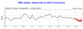
Those are some really good analogs for usToday’s GEFS PNA forecast is the most negative for this Dec that I can recall:
View attachment 178800
This implies the realistic chance for a sub -1 Dec PNA. Whereas that’s bad news for those wanting E US cold in the 2nd half of Dec in the MidAtlantic/OH Valley south, it isn’t necessarily bad news for January prospects. That’s because in the vast majority of cases for -ENSO, the PNA in January rose sharply from Dec:
PNA Dec/Jan for -ENSO for strongly -PNA in Dec
- 1955-6: -2.1/-1.3 (rose 0.8)
- 1961-2: -1.2/-0.1 (rose 1.1)
- 1964-5: -1.7/-0.2 (rose 1.5)
- 1971-2: -1.5/-1.4 (rose 0.1)
- 1984-5: -1.6/+1.6 (rose 3.2)
- 1996-7: -1.2/+0.6 (rose 1.8)
- 2008-9: -1.4/+0.6 (rose 2.0)
- 2010-1: -1.8/+1.3 (rose 3.1)
- 2012-3: -1.0/+0.6 (rose 1.6)
- 2013-4: -0.9/+1.0 (rose 1.9)
- 2021-2: -1.6/+1.0 (rose 2.6)
So, average PNA rise Dec to Jan for these was a whopping 1.8!
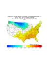
Dec temperature anomalies: coldest N Rockies to N Plains/mild much of SE 1/3:
View attachment 178801
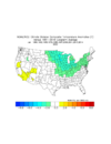
Jan temp. anomalies: coldest shifts 1,000 miles SE and warmth gone
View attachment 178802
I saw a lot of really good analogs rolled out earlier in November when there was an early strat warm and some more really good ones when there was a big phase 8 run in December. IThose are some really good analogs for us
But things don't work like the used to so there's no use in the anal logs.I saw a lot of really good analogs rolled out earlier in November when there was an early strat warm and some more really good ones when there was a big phase 8 run in December. Ianalogs

I don’t know much about him, and no disrespect, but I think I’ve read his stuff before and he leans to the “ cold weenie” side of things usually!? I’m not sure of his accuracy!?Yes, I said hope! I am an unabashed lover of weather extremes, particularly those which "fit the season". With many model forecasts and human projections of a major warm-up across the lower 48 states for the holiday period, those like me who want a big cold wave or heavy snow and ice event have to wait out at least 6 days of some cases of record warmth before an Arctic intrusion returns to the lower 48 states. The question is, could the warmth last further? If you based odds on the model guidance alone, the odds on a cAk placement below the Canadian border are about 3 in 7. The American and European series are closest to the analog support, but the GEFS and ECMWF versions have members that show a return to a broad +PNA/-AO/-NAO signature that would return the eastern half of the continent to an extremely cold scenario with chances for snow in the Great Lakes and the Eastern Seaboard.
Cautions I apply to the forecast: do NOT make assumptions based on the Madden-Julian Oscillation predictions (see what I mean about all of that "Phase 8" nonsense that was the talk of the internet?). Remind yourself that for an MJO cold influence in North America, the lead impulse should be between Phases 6 and 1, be very strong, and have at least some connection to the polar westerlies. The numerical model Wheeler diagrams are not useful in this regard. Also, for a Sudden Stratospheric Warming alteration in sensible weather, consider that the 10MB warm anomaly should be on the American side of the North Pole, should foreshadow a high-latitude blocking signature and will occur 2 to 4 weeks following the SSW. You would want to see either some splitting or persistent positioning of the warming pool. Using previous stratospheric warming projections, I suspect that the lower 48 states are going to feel another cold wave in the Christmas/New Year hammock week, and maybe 5 to 7 days beyond. On the idea that we see a climatologically-favored "January Thaw, the middle of next month could be as warm as what we are looking at by this weekend. But I concur with the analog set that the latter third of the first month of the new year will turn quite cold, perhaps lasting through February with better potential for ice, snow further south and east than before.
Clues to look at: the expanded snow and ice cover, similarities to 2007 and 2024-25. Around Christmas or shortly thereafter, winter should fight its way back into the U.S.
Prepared by Meteorologist LARRY COSGROVE on
Saturday, December 13, 2025 at 11:20 P.M. CT
Yes, I said hope! I am an unabashed lover of weather extremes, particularly those which "fit the season". With many model forecasts and human projections of a major warm-up across the lower 48 states for the holiday period, those like me who want a big cold wave or heavy snow and ice event have to wait out at least 6 days of some cases of record warmth before an Arctic intrusion returns to the lower 48 states. The question is, could the warmth last further? If you based odds on the model guidance alone, the odds on a cAk placement below the Canadian border are about 3 in 7. The American and European series are closest to the analog support, but the GEFS and ECMWF versions have members that show a return to a broad +PNA/-AO/-NAO signature that would return the eastern half of the continent to an extremely cold scenario with chances for snow in the Great Lakes and the Eastern Seaboard.
Cautions I apply to the forecast: do NOT make assumptions based on the Madden-Julian Oscillation predictions (see what I mean about all of that "Phase 8" nonsense that was the talk of the internet?). Remind yourself that for an MJO cold influence in North America, the lead impulse should be between Phases 6 and 1, be very strong, and have at least some connection to the polar westerlies. The numerical model Wheeler diagrams are not useful in this regard. Also, for a Sudden Stratospheric Warming alteration in sensible weather, consider that the 10MB warm anomaly should be on the American side of the North Pole, should foreshadow a high-latitude blocking signature and will occur 2 to 4 weeks following the SSW. You would want to see either some splitting or persistent positioning of the warming pool. Using previous stratospheric warming projections, I suspect that the lower 48 states are going to feel another cold wave in the Christmas/New Year hammock week, and maybe 5 to 7 days beyond. On the idea that we see a climatologically-favored "January Thaw, the middle of next month could be as warm as what we are looking at by this weekend. But I concur with the analog set that the latter third of the first month of the new year will turn quite cold, perhaps lasting through February with better potential for ice, snow further south and east than before.
Clues to look at: the expanded snow and ice cover, similarities to 2007 and 2024-25. Around Christmas or shortly thereafter, winter should fight its way back into the U.S.
Prepared by Meteorologist LARRY COSGROVE on
Saturday, December 13, 2025 at 11:20 P.M. CT
He is going to be correct Brent. Santa with shorts on and a Jim beam in his left handDidn't he say Christmas was gonna be a memorable week last week?
Oh it's gonna be memorable alright
Yeah be glad eat my Xmas dinner on backdeck with burgers and steaks on the grillDidn't he say Christmas was gonna be a memorable week last week?
Oh it's gonna be memorable alright
lol same thing every year. Posters point to MLK day, Then the Valentine’s Day time frame followed by “I think we got a shot last week of Feb” happens every year.If I had to make an educated guess and pick the coldest day in January relative to climo normals, then I would say the 19th (MLK Jr Day), based on a combination of wave cycle patterns the last few months, . MJO progression, and the Aleutian ridge life cycle. Then +/-3 days from Jan 19th for our best shot for a board wide winter storm. We'll have some cold shots and wintry chances before and after then, but Jan 16th-22nd is the timeframe I think we'll see peak winter 2025-26.
Well that period was when the south got its biggest snowstorm last year. Right around Jan 21.If I had to make an educated guess and pick the coldest day in January relative to climo normals, then I would say the 19th (MLK Jr Day), based on a combination of wave cycle patterns the last few months, . MJO progression, and the Aleutian ridge life cycle. Then +/-3 days from Jan 19th for our best shot for a board wide winter storm. We'll have some cold shots and wintry chances before and after then, but Jan 16th-22nd is the timeframe I think we'll see peak winter 2025-26.
March 1960 always comes up as a Hail Mary!lol same thing every year. Posters point to MLK day, Then the Valentine’s Day time frame followed by “I think we got a shot last week of Feb” happens every year.
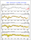
On 12/26/21, when the PNA had been negative all month/way down at -1.8 that day, GSO’s high that day was a miserably mild 72 with very mild to continue through New Year’s, and Dec was the mildest Dec since 2015, this (see image below) was the 12/26/21 GEFS two week PNA forecast, which went to 1/9/22: still down at -0.6 on 1/9/22 and no clearcut sign that 1/9/22 was going to be the start of a 38 day long +PNA as well as Jan ending up the snowiest Jan at GSO since Jan of 2002 along with it being the coldest month there since Jan of 2018:
View attachment 179260
The main points are that:
- The models can’t see out that far with notable skill and that includes forecasting the PNA/general patterns
- -ENSO -PNA Decembers since 1984 all transitioned to +PNA Jans
This Dec -PNA to Jan +PNA relationship completely reverses when you go back into the 1940s-1970s for cold enso events.
Likely lots of internal variability and multidecadal dependence.
Eric,
Whereas randomness/luck is always a factor to consider, I lean more toward the multidecadal dependence, perhaps at least partially climate change related, as probably a bigger factor in this case than randomness since the sample size is decent.
Also, Don Sutherland said this to me today in response to the same topic:
It will be interesting to see how things evolve. Since 1980, December PNA- cases have been followed by January PNA+ cases. Prior to 1980, December PNA- cases were generally followed by January PNA- cases. It is possible that the less stable PNA state is, at least in part, a result of Arctic amplification.
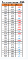 If it is truly random, the 9 -PNA Dec to +PNA Jan since 1980 (excluding 1992 which rose but was not positive in Jan) the odds of coin flip +PNAs for 9 out of 10 years is 1 in 102.4.
That’s really interesting how you can see a long-term trend there in that chart. Part of me also wonders if the CPC is properly detrending their height anomaly dataView attachment 179267 If it is truly random, the 9 -PNA Dec to +PNA Jan since 1980 (excluding 1992 which rose but was not positive in Jan) the odds of coin flip +PNAs for 9 out of 10 years is 1 in 102.4.
If 2026 goes positive in Jan, the random odds of 10 out of 11 years are 1 in 186.2.
If you include 1992 as a positive due to the rise that Jan, the odds of 10 out of 10 years random flip are 1 in 1,024. The odds of going 11 for 11 at random if Jan 2026 goes positive are 1 in 2,048!
I stole this graph off AmericaWX, I have no way of confirming the accuracy of those years listed but it looks trustworthy. Someone can confirm it, I just like the random math since randomness/luck has been thrown around. I suspect there is more to it than that.
Makes you wonder if it’s all government controlled….Kidding kidding…. Or am I..That’s really interesting how you can see a long-term trend there in that chart. Part of me also wonders if the CPC is properly detrending their height anomaly data
View attachment 179267 If it is truly random, the 9 -PNA Dec to +PNA Jan since 1980 (excluding 1992 which rose but was not positive in Jan) the odds of coin flip +PNAs for 9 out of 10 years is 1 in 102.4.
If 2026 goes positive in Jan, the random odds of 10 out of 11 years are 1 in 186.2.
If you include 1992 as a positive due to the rise that Jan, the odds of 10 out of 10 years random flip are 1 in 1,024. The odds of going 11 for 11 at random if Jan 2026 goes positive are 1 in 2,048!
I stole this graph off AmericaWX, I have no way of confirming the accuracy of those years listed but it looks trustworthy. Someone can confirm it, I just like the random math since randomness/luck has been thrown around. I suspect there is more to it than that.
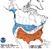
The image below is how it looked for Jan 2022 at this time, when instead of one of the coldest week 3-4 outlooks on record for the SE half of the US like was the case for Jan of 2025, it was suggesting that a mild SE half of the US was a much better possibility. This is when there was a similar very strong -PNA to what’s being forecasted for late Dec:
View attachment 179308
How did Jan 8-21, 2022 verify in Greensboro, NC? They ended up 4 BELOW normal and had two 1”+ snowfalls. So, one would have had no clue from NOAA even as late as Dec 24th of 2021 that a cold and snowy Jan of 2022 in much of the E US was incoming. The point is that sometimes the extended models don’t have a clue.
No clue? Well I definitely talked about it... a lot.
Sometimes they don’t have a clue but this isn’t 2022 or last year for that matter (as some have also tried to latch onto). I just think folks are grasping onto straws here.
Good luck. Got be on drugs lolJust trying to provide some hope. Probably one of the better Euro weekly runs in awhile. Fun to look at atleast.
View attachment 179306
