If I'm looking at the records right, it looks like it's been nearly 15 years since Charlotte had at least 5" of snow from a single storm.
-
Hello, please take a minute to check out our awesome content, contributed by the wonderful members of our community. We hope you'll add your own thoughts and opinions by making a free account!
You are using an out of date browser. It may not display this or other websites correctly.
You should upgrade or use an alternative browser.
You should upgrade or use an alternative browser.
Wintry Winter 2018-19 Discussion
- Thread starter Snowfan
- Start date
dpbutler1
Member
If I'm looking at the records right, it looks like it's been nearly 15 years since Charlotte had at least 5" of snow from a single storm.
That is not correct. February 2014 had more then 5 inches in Charlotte from that storm. I remember I had 9 to 10 inches of snow over at my apartment.
Attachments
Ok what I was looking at was showing the most snow in a single day. So Charlotte has not had more than 5" in a single day since 2004.That is not correct. February 2014 had more then 5 inches in Charlotte from that storm. I remember I had 9 to 10 inches of snow over at my apartment.
dpbutler1
Member
That is correct if you are looking at daily snowfall total at the charlotte airport. February 2014 was close with 4.7 inches.Ok what I was looking at was showing the most snow in a single day. So Charlotte has not had more than 5" in a single day since 2004.
 Boom! Pioneer leading the way!!!
Storm5
Member
Winter cancel

Sent from my iPhone using Tapatalk

Sent from my iPhone using Tapatalk
RollTide18
Member
Winter cancel
Sent from my iPhone using Tapatalk
Yikes, that’s not a good start.
NoSnowATL
Member
Fake newsYikes, that’s not a good start.
accu35
Member
Welp, winter didn't last long lol.Yikes, that’s not a good start.
Storm5
Member
Welp, winter didn't last long lol.
The CFS sucks . Just wait till the next cycle . It will show something different
Sent from my iPhone using Tapatalk
whatalife
Moderator
Winter cancel
Sent from my iPhone using Tapatalk
Why don’t we just roll with this CFS run. That way we won’t be as depressed when this run happens

Sent from my iPhone using Tapatalk
Is this the same CFS that showed a warm November?
cd2play
Member
Looks like a CAD signature to me, as in "Where's the Cold Air Dammit?"Why don’t we just roll with this CFS run. That way we won’t be as depressed when this run happens
Sent from my iPhone using Tapatalk
 Hug the Eukie !!!!!!!!! From the other place!
 Steady as she blows!
Brent
Member
well at least this blizzard in the Plains is laying down snow pack
If the -AAM, which is normally associated with La Nina, doesn't go away by winter, would that mean a stubborn SE ridge this winter, which has been the case this month, despite El Nino? If so, folks such as Phil, Stormsfury, and myself would have a much lower chance for a cold winter relative to normal. The warm nearby Atlantic and Gulf could aid in this although hopefully not.
So, would a continued -AAM mean a good chance of a sharp contrast over the SE with coldest relative to normals with coldest near Memphis and warmest in FL/near SE coast? Does anyone have a link to an AAM history table by month?
Edit: Looking at DJF temperature anomalies, the only El Ninos I found with what looks like the warmest SE US anomalies being near the SE coast and in FL were 1958-9, 1972-3, 2006-7, and 2014-5. Did any of these have a dominant -AAM despite El Nino?
Edit #2: Regarding the stubborn SER, Nov will end it right at normal here and Phil will end up at least +2 it appears despite very cold places such as Memphis and Birm. and chilly places such as ATL and RDU. I'm not complaining though as normal Nov wx is quite pleasant.
Last edited:
Webberweather53
Meteorologist
The AAM is raging positive atm, excess westerly momentum is trying to move poleward into the mid-latitudes while easterly momentum dominates near the surf zone, a configuration that's favorable for high-latitude blocking, at least for now.

The AAM is raging positive atm, excess westerly momentum is trying to move poleward into the mid-latitudes while easterly momentum dominates near the surf zone, a configuration that's favorable for high-latitude blocking, at least for now.
View attachment 7628
Thanks for this info. I had been thinking the AAM was still negative but I see on your graph that it actually switched in Oct to + and for the moment strongly + as you noted. That jibes much better with El Nino vs the - of Sept. Now, it will be interesting to see if the near Dateline OLR finally switches to negative soon, if it hasn't already done so this month. Oct still had +OLR, which was unprecedented back to 1976 for El Nino.
Last edited:
Storm5
Member
There are ways to screw winter up

Sent from my iPhone using Tapatalk

Sent from my iPhone using Tapatalk
cd2play
Member
That would be Armageddon for winter 2018-19, but I'm putting that on "ignore" for now due to no support from the ensembles.There are ways to screw winter up
Sent from my iPhone using Tapatalk
Kylo
Member
Hoping for a 77/78 flip. Fairly ugly Dec pattern, Aleutian ridge, pac low over AK. Then the cold came and was frigid through mid-March.


That was a relatively snowless winter, in most of the SE!?Hoping for a 77/78 flip. Fairly ugly Dec pattern, Aleutian ridge, pac low over AK. Then the cold came and was frigid through mid-March.
View attachment 7647
View attachment 7645
Kylo
Member
Really? RDU had 10”. What did GSP/CLT have?That was a relatively snowless winter, in most of the SE!?
That would be Armageddon for winter 2018-19, but I'm putting that on "ignore" for now due to no support from the ensembles.
Im putting that on ignore because that guys track record on winter is about as good as Spann's track record on GOM hurricanes.
9
93Storm
Guest
I recently came across the article from Accuweather. Their prediction maps look exciting, but of course, there's no promises.
https://m.accuweather.com/en/weathe...ough-winter-ahead-for-the-eastern-us/70006644
https://m.accuweather.com/en/weathe...ough-winter-ahead-for-the-eastern-us/70006644
NoSnowATL
Member
Pretty much goes with other forecast so I’m happy, we just have to stay calm and wait, it’s hard but If everything works out January- March will be exciting. Just have to stay calm for another 4+ weeks.I recently came across the article from Accuweather. Their prediction maps look exciting, but of course, there's no promises.
https://m.accuweather.com/en/weathe...ough-winter-ahead-for-the-eastern-us/70006644
Coach B
Member
For Nashville:That was a relatively snowless winter, in most of the SE!?
1/9/78 - 3/4/78:
*24" of snow
*31 days with a T or more of snow
*23 days with highs below freezing
*50 days with snowcover
*36 consecutive days with snowcover from 1/9 thru 2/13
*10 winter events
*only 2 rain events
*only 1 day out of 63 above normal
*only 1 day out of 63 with a high over 50
Last edited:
I’m not sure about GSP, but chances are, if TN jackpotted that much, we probably didn’t do too well, but I could be wrong!? Our winter avg is like 5”, it wouldn’t take much to make an epic winter!For Nashville:
1/9/78 - 3/4/78:
*24" of snow
*31 days with a T or more of snow
*50 days with snowcover
*incredible 36 straight days with snowcover from 1/9 thru 2/13
*23 days with highs below freezing
*10 winter events
*only 2 rain events
*only 1 day out of 63 above normal
*only 1 day out of 63 with a high over 50
olhausen
Member
I would trade my left umm...hand for a winter like that.For Nashville:
1/9/78 - 3/4/78:
*24" of snow
*31 days with a T or more of snow
*23 days with highs below freezing
*50 days with snowcover
*36 consecutive days with snowcover from 1/9 thru 2/13
*10 winter events
*only 2 rain events
*only 1 day out of 63 above normal
*only 1 day out of 63 with a high over 50
Webberweather53
Meteorologist
whatalife
Moderator
So we wait till March for winter. (Sarcasm) LOL!
Sent from my iPhone using Tapatalk
NoSnowATL
Member
Might be February........ heck that’s about normal.So we wait till March for winter. (Sarcasm) LOL!
Sent from my iPhone using Tapatalk
So we throw away our 2 coldest months (Dec and Jan) and pray for a Feb miracle ? Yep thats a typical SE winter.Might be February........ heck that’s about normal.
March looks coldest! Noice!! Can’t get more backloaded than that!
cd2play
Member
I tend to believe winter gets here on January 31 this yearSo we throw away our 2 coldest months (Dec and Jan) and pray for a Feb miracle ? Yep thats a typical SE winter.
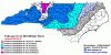
This map is the snowfall analysis, starting from, 9/30/18 to 11/27/18.
Link: https://www.nohrsc.noaa.gov/snowfall/

Link: https://www.nohrsc.noaa.gov/snowfall/

Last edited:
Upstate SC hasn’t had any snow. Maybe some ice in the Spartanburg area from that system last week but idk about .1-1”. Am I missing something?This map is the snowfall analysis, starting from, 9/30/18 to 11/27/18.
Believe ice counts as snow on this map also.Upstate SC hasn’t had any snow. Maybe some ice in the Spartanburg area from that system last week but idk about .1-1”. Am I missing something?
Grief. Well if I got .1” of ice this is the first I’ve heard about itBelieve ice counts as snow on this map also.