GeorgiaGirl
Member
Looking pretty good, good thing it's July and not August and it's path is to the graveyard as others have said...


He usually does good videos but I have to say he does do a lot of videos
Survive yes but even CAT5 struggles in the graveyard of the eastern Caribbean. If it goes north, then no weakening but likely recurve.If the storm slows down and and strengthens it could very well survive the hostile environment? Plus pull more north as it gets stronger. I've also noticed the size of the storm is flexing little more.
I understand completely, I'm not all that great when it comes to tropical discussion but I learn from you guys a lot. Hey thanks for informing me!!!Survive yes but even CAT5 struggles in the graveyard of the eastern Caribbean. If it goes north, then no weakening but likely recurve.


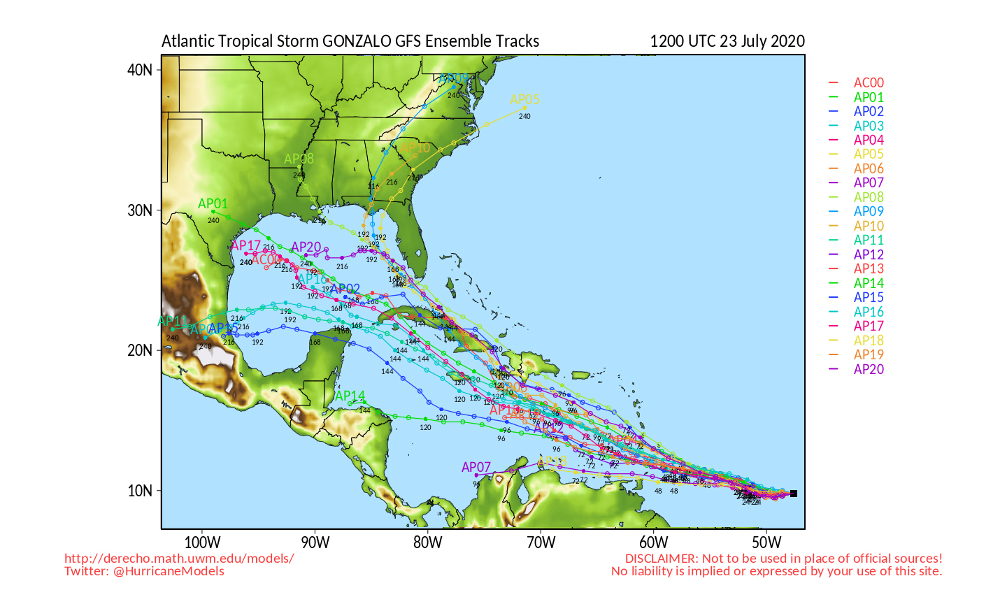
12z GEFS
View attachment 44753
Looks like some do but it looks more impressive than previous runs.Never gets it under 1000mb?


That's not Gonzalo. That's the wave behind it that the Euro has been rather bullish with. Some big dogs this run:


That's not Gonzalo. That's the wave behind it that the Euro has been rather bullish with. Some big dogs this run:
View attachment 44761View attachment 44762
Curious where I can find a link to that?
That's not Gonzalo. That's the wave behind it that the Euro has been rather bullish with. Some big dogs this run:
View attachment 44761View attachment 44762
BULLETIN
Tropical Storm Gonzalo Advisory Number 5
NWS National Hurricane Center Miami FL AL072020
500 PM AST Wed Jul 22 2020
...GONZALO MOVING WESTWARD WITH LITTLE CHANGE IN STRENGTH DURING
THE PAST SEVERAL HOURS...
...EXPECTED TO BECOME A HURRICANE BY THURSDAY...
SUMMARY OF 500 PM AST...2100 UTC...INFORMATION
----------------------------------------------
LOCATION...9.9N 45.0W
ABOUT 1110 MI...1785 KM E OF THE SOUTHERN WINDWARD ISLANDS
MAXIMUM SUSTAINED WINDS...50 MPH...85 KM/H
PRESENT MOVEMENT...W OR 270 DEGREES AT 14 MPH...22 KM/H
MINIMUM CENTRAL PRESSURE...1000 MB...29.53 INCHES


Here’s the 00z spaghetti models and the 18z GEFS.
View attachment 44769View attachment 44770View attachment 44771
BULLETIN
Tropical Storm Gonzalo Intermediate Advisory Number 7A
NWS National Hurricane Center Miami FL AL072020
800 AM AST Thu Jul 23 2020
...GONZALO CONTINUES WESTWARD...
...HURRICANE WATCH ISSUED FOR ST. VINCENT AND THE GRENADINES...
SUMMARY OF 800 AM AST...1200 UTC...INFORMATION
----------------------------------------------
LOCATION...9.8N 47.9W
ABOUT 910 MI...1470 KM E OF THE SOUTHERN WINDWARD ISLANDS
MAXIMUM SUSTAINED WINDS...65 MPH...100 KM/H
PRESENT MOVEMENT...W OR 270 DEGREES AT 12 MPH...19 KM/H
MINIMUM CENTRAL PRESSURE...997 MB...29.44 INCHES
WATCHES AND WARNINGS
--------------------
CHANGES WITH THIS ADVISORY...
The government of Barbados has issued a Hurricane Watch for St.
Vincent and the Grenadines.
SUMMARY OF WATCHES AND WARNING IN EFFECT...
A Hurricane Watch is in effect for...
* Barbados
* St. Vincent and the Grenadines
A Hurricane Watch means that hurricane conditions are possible
within the watch area. A watch is typically issued 48 hours before
the anticipated first occurrence of tropical-storm-force winds,
conditions that make outside preparations difficult or dangerous.
Interests in the Windward Islands should monitor the progress of
this system. Additional watches or warnings will likely be
required for some of these islands later today.
For storm information specific to your area, please monitor
products issued by your national meteorological service.
BULLETIN
Tropical Storm Gonzalo Advisory Number 8
NWS National Hurricane Center Miami FL AL072020
1100 AM AST Thu Jul 23 2020
...GONZALO FACES AN UNCERTAIN FUTURE...
...BUT EXPECTED TO BEGIN AFFECTING PORTIONS OF THE WINDWARD ISLANDS
ON SATURDAY...
SUMMARY OF 1100 AM AST...1500 UTC...INFORMATION
-----------------------------------------------
LOCATION...9.6N 48.3W
ABOUT 885 MI...1425 KM E OF THE SOUTHERN WINDWARD ISLANDS
MAXIMUM SUSTAINED WINDS...65 MPH...100 KM/H
PRESENT MOVEMENT...W OR 270 DEGREES AT 14 MPH...22 KM/H
MINIMUM CENTRAL PRESSURE...997 MB...29.44 INCHES
BULLETIN
Tropical Storm Gonzalo Intermediate Advisory Number 8A
NWS National Hurricane Center Miami FL AL072020
200 PM AST Thu Jul 23 2020
...GONZALO A LITTLE WEAKER...
SUMMARY OF 200 PM AST...1800 UTC...INFORMATION
----------------------------------------------
LOCATION...9.7N 48.8W
ABOUT 850 MI...1370 KM E OF THE SOUTHERN WINDWARD ISLANDS
MAXIMUM SUSTAINED WINDS...60 MPH...95 KM/H
PRESENT MOVEMENT...W OR 270 DEGREES AT 14 MPH...22 KM/H
MINIMUM CENTRAL PRESSURE...1000 MB...29.53 INCHES
BULLETIN
Tropical Storm Gonzalo Advisory Number 9
NWS National Hurricane Center Miami FL AL072020
500 PM AST Thu Jul 23 2020
...GONZALO CONTINUES WESTWARD...
...EXPECTED TO BEGIN AFFECTING PORTIONS OF THE SOUTHERN WINDWARD
ISLANDS ON SATURDAY...
SUMMARY OF 500 PM AST...2100 UTC...INFORMATION
----------------------------------------------
LOCATION...9.8N 49.4W
ABOUT 810 MI...1305 KM E OF THE SOUTHERN WINDWARD ISLANDS
MAXIMUM SUSTAINED WINDS...60 MPH...95 KM/H
PRESENT MOVEMENT...W OR 275 DEGREES AT 13 MPH...20 KM/H
MINIMUM CENTRAL PRESSURE...1000 MB...29.53 INCHES
WATCHES AND WARNINGS
--------------------
CHANGES WITH THIS ADVISORY...
The government of Trinidad and Tobago has issued a Tropical Storm
Watch for Tobago and Grenada.
SUMMARY OF WATCHES AND WARNING IN EFFECT...
A Hurricane Watch is in effect for...
* Barbados
* St. Vincent and the Grenadines
A Tropical Storm Watch is in effect for...
* Tobago
* Grenada
A Hurricane Watch means that hurricane conditions are possible
within the watch area. A watch is typically issued 48 hours before
the anticipated first occurrence of tropical-storm-force winds,
conditions that make outside preparations difficult or dangerous.
A Tropical Storm Watch means that tropical storm conditions are
possible within the watch area, generally within 48 hours.
Interests elsewhere in the Windward Islands should monitor the
progress of this system. Additional watches or warnings will
likely be required for some of these islands tonight or on Friday.
For storm information specific to your area, please monitor
products issued by your national meteorological service.
BULLETIN
Tropical Storm Gonzalo Intermediate Advisory Number 9A
NWS National Hurricane Center Miami FL AL072020
800 PM AST Thu Jul 23 2020
...GONZALO STILL HEADING DUE WEST...
...EXPECTED TO BEGIN AFFECTING PORTIONS OF THE SOUTHERN WINDWARD
ISLANDS ON SATURDAY...
SUMMARY OF 800 PM AST...0000 UTC...INFORMATION
----------------------------------------------
LOCATION...9.7N 49.9W
ABOUT 775 MI...1250 KM E OF THE SOUTHERN WINDWARD ISLANDS
MAXIMUM SUSTAINED WINDS...60 MPH...95 KM/H
PRESENT MOVEMENT...W OR 275 DEGREES AT 13 MPH...20 KM/H
MINIMUM CENTRAL PRESSURE...1000 MB...29.53 INCHES
BULLETIN
Tropical Storm Gonzalo Advisory Number 10
NWS National Hurricane Center Miami FL AL072020
1100 PM AST Thu Jul 23 2020
...GONZALO A LITTLE BETTER ORGANIZED...
...EXPECTED TO BEGIN AFFECTING PORTIONS OF THE SOUTHERN WINDWARD
ISLANDS ON SATURDAY...
SUMMARY OF 1100 PM AST...0300 UTC...INFORMATION
-----------------------------------------------
LOCATION...9.9N 50.6W
ABOUT 730 MI...1170 KM E OF THE SOUTHERN WINDWARD ISLANDS
MAXIMUM SUSTAINED WINDS...60 MPH...95 KM/H
PRESENT MOVEMENT...W OR 275 DEGREES AT 14 MPH...22 KM/H
MINIMUM CENTRAL PRESSURE...1000 MB...29.53 INCHES
BULLETIN
Tropical Storm Gonzalo Intermediate Advisory Number 11A
NWS National Hurricane Center Miami FL AL072020
800 AM AST Fri Jul 24 2020
...GONZALO FORECAST TO BRING TROPICAL STORM CONDITIONS TO THE
SOUTHERN WINDWARD ISLANDS ON SATURDAY...
SUMMARY OF 800 AM AST...1200 UTC...INFORMATION
----------------------------------------------
LOCATION...10.0N 52.8W
ABOUT 580 MI...930 KM E OF THE SOUTHERN WINDWARD ISLANDS
MAXIMUM SUSTAINED WINDS...60 MPH...95 KM/H
PRESENT MOVEMENT...W OR 275 DEGREES AT 15 MPH...24 KM/H
MINIMUM CENTRAL PRESSURE...1000 MB...29.53 INCHES
 www.charlottestories.com

Gonzalo has weakened a bit.BULLETIN
Tropical Storm Gonzalo Advisory Number 12
NWS National Hurricane Center Miami FL AL072020
1100 AM AST Fri Jul 24 2020
...GONZALO ACCELERATES TOWARD THE SOUTHERN WINDWARD ISLANDS...
...EXPECTED TO BRING TROPICAL STORM CONDITIONS TO PORTIONS OF THE
ISLANDS ON SATURDAY...
SUMMARY OF 1100 AM AST...1500 UTC...INFORMATION
-----------------------------------------------
LOCATION...10.0N 54.2W
ABOUT 485 MI...780 KM E OF THE SOUTHERN WINDWARD ISLANDS
MAXIMUM SUSTAINED WINDS...50 MPH...85 KM/H
PRESENT MOVEMENT...W OR 275 DEGREES AT 18 MPH...30 KM/H
MINIMUM CENTRAL PRESSURE...1002 MB...29.59 INCHES