Definetly the biggest shift I've seen.Hilarious 3 run change
View attachment 174206
-
Hello, please take a minute to check out our awesome content, contributed by the wonderful members of our community. We hope you'll add your own thoughts and opinions by making a free account!
You are using an out of date browser. It may not display this or other websites correctly.
You should upgrade or use an alternative browser.
You should upgrade or use an alternative browser.
Tropical TS Erin
- Thread starter SD
- Start date
Henry2326
Member
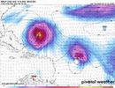
Hilarious 3 run change
View attachment 174206
GFS hasn't caught up yet.
Euro AI 3 run change. Not as big but it was already close enough and still shifted west.

12z EPS so far

Might have 1-2 actual landfalls on the EPS and about 5 very close calls. This definitely got more interesting

Henry2326
Member
In more recent memory....Helene hit South GA at 100 mph. Valdosta GA, my family is there, was demolished. It was supposed to go up the west side of the state to Atlanta. It goes the east side of the state and destroys Augusta, then takes out NC.while i know what you mean, should be noted that this was 7 years ago and models have indeed improved a little and newer hurricane models have been introduced since then- in some cases probably to better prognosticate storms like michael
No, respectfully disagree, it hasn't gotten any better.
Henry2326
Member
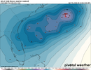
Dang, look at the spread. Not even close to a general idea.Might have 1-2 actual landfalls on the EPS and about 5 very close calls. This definitely got more interesting
View attachment 174209
Wonder if that ridge over the US/Can would have been able to flex more without that little trough embedded in the middle over MN/WI, and make it even harder for her to turn north. Atlantic ridge flex/bridge with CONUS ridge had more to do with the western shift this run, but could be something to watch

GeorgiaGirl
Member
If that Euro run were to verify, you could actually prob argue for hurricane warnings on the OBX. Was thinking so privately, and just saw a met on storm2k say there'd probably be hurricane force gusts there with this track.
Def a yikes, and I will say the GFS seems a bit out to lunch for now with how low Erin is tracking. She's probably just a bit above 16N.
Def a yikes, and I will say the GFS seems a bit out to lunch for now with how low Erin is tracking. She's probably just a bit above 16N.
Henry2326
Member
Wonder if that ridge over the US/Can would have been able to flex more without that little trough embedded in the middle over MN/WI, and make it even harder for her to turn north. Atlantic ridge flex/bridge with CONUS ridge had more to do with the western shift this run, but could be something to watch
View attachment 174211
To your point, 4 days ago Euro AI published this 8/9 00z.
Edit: just read the post from Webb. This also demonstrates what he is saying.


The central Canadian ridge appears to be flatter at 12Z, allowing the trough in SE Canada to move more west-east instead of more north-south vs the 0Z run. May have to do with the very thing you suggested.Wonder if that ridge over the US/Can would have been able to flex more without that little trough embedded in the middle over MN/WI, and make it even harder for her to turn north. Atlantic ridge flex/bridge with CONUS ridge had more to do with the western shift this run, but could be something to watch
View attachment 174211
Lots to watch, but quite often this season, those troughs have had no trouble making it into the NE, which would be the saving grace here.


Will be worth watching trend on the PNW/GOA low’s strength as well as that can impact the ridge downstreamThe central Canadian ridge appears to be flatter at 12Z, allowing the trough in SE Canada to move more west-east instead of more north-south vs the 0Z run. May have to do with the very thing you suggested.
Lots to watch, but quite often this season, those troughs have had no trouble making it into the NE, which would be the saving grace here.
View attachment 174214
View attachment 174215
“this won’t make landfall” gang in dire straits
sorry that’s all I’ve got to add. I will say it seems every year we’re worried about the OBX washing away from a hurricane. It will one day but I’d bet the streak on it not washing away yet.
-Jimmy
sorry that’s all I’ve got to add. I will say it seems every year we’re worried about the OBX washing away from a hurricane. It will one day but I’d bet the streak on it not washing away yet.
-Jimmy
CJ honking 
lexxnchloe
Member
The GFS is going to have to shift west as well for this to validate
lexxnchloe
Member
ICON looks like it wants to vacation in the Bahamas at 18z

Henry2326
Member
HAFS-A and B consistent with IconFrom elsewhere: all progging majors
12z, August 13, hurricane model blend, Erin
--- Model peak intensity ---
HWRF = 944mb/117kt
HMON = 952mb/115kt
HAFS-A = 932mb/126kt
HAFS-B = 928mb/127kt
The other 2 consistent with Euro and Euro AI
Henry2326
Member
And it's further west and south than 12z, I think would put it on top of Euro. We will see at 00z.
Tried to do a comparison but it won't cooperate.
Henry2326
Member
She's cooking......

Some things never change. If you routinely use the GFS for tropical forecasting, I admire you.

The Euro is definitely concerning. The escape hatch is narrowing, but it isn't closed. 6 days out, we know synoptically things are going to change and certainly storm scale will as well. The retreating of the upper low is a major reversal in trends and likely portends real trouble if that holds.

The Euro is definitely concerning. The escape hatch is narrowing, but it isn't closed. 6 days out, we know synoptically things are going to change and certainly storm scale will as well. The retreating of the upper low is a major reversal in trends and likely portends real trouble if that holds.
Last edited:
We’re a couple shifts away from this getting hung up in Hispaniola on the Icon

lexxnchloe
Member
12ZWe’re a couple shifts away from this getting hung up in Hispaniola on the Icon
View attachment 174226

0Z

I mean, it is the ICON, but the Euro just had a shift this big at 12z. Models seem to really be struggling with this one

lexxnchloe
Member
I mean, it is the ICON, but the Euro just had a shift this big at 12z. Models seem to really be struggling with this one
View attachment 174230

Looks as if it’ll miss OBX on this run, but a 930-940mb hurricane that close to the Southeast coast would be spooky as hell.
Really didn’t want to stay up for the Euro but that may be enough to convince me
Really didn’t want to stay up for the Euro but that may be enough to convince me
0Z UKMET is similar to 12Z with recurve at 71.7W
TROPICAL STORM ERIN ANALYSED POSITION : 16.4N 45.8W
ATCF IDENTIFIER : AL052025
LEAD CENTRAL MAXIMUM WIND
VERIFYING TIME TIME POSITION PRESSURE (MB) SPEED (KNOTS)
-------------- ---- -------- ------------- -------------
0000UTC 14.08.2025 0 16.4N 45.8W 1007 31
1200UTC 14.08.2025 12 16.7N 48.8W 1006 31
0000UTC 15.08.2025 24 17.8N 51.8W 1006 32
1200UTC 15.08.2025 36 19.0N 55.5W 1006 32
0000UTC 16.08.2025 48 20.0N 58.9W 1005 33
1200UTC 16.08.2025 60 20.5N 62.6W 1002 33
0000UTC 17.08.2025 72 20.4N 65.4W 999 32
1200UTC 17.08.2025 84 20.6N 67.2W 997 34
0000UTC 18.08.2025 96 22.3N 68.2W 994 40
1200UTC 18.08.2025 108 24.2N 69.6W 992 44
0000UTC 19.08.2025 120 26.1N 70.6W 989 46
1200UTC 19.08.2025 132 27.9N 71.3W 986 50
0000UTC 20.08.2025 144 30.0N 71.7W 982 52
1200UTC 20.08.2025 156 32.5N 71.5W 979 58
0000UTC 21.08.2025 168 35.0N 70.3W 972 62
Euro back east this run, splitting the uprights between OBX and Bermuda. I think the windshield wiper is in full effect now. Hopefully the HH can get some good data today.
lexxnchloe
Member
GFS and EURO both well eastEuro back east this run, splitting the uprights between OBX and Bermuda. I think the windshield wiper is in full effect now. Hopefully the HH can get some good data today.
Brent
Member
In the 5am discussion
There is still a greater than normal uncertainty about what
impacts Erin may bring to portions of the Bahamas, the east coast of
the United States, and Bermuda in the long range.
And yes the hurricane hunters are suppose to fly out this evening for the first time
There is still a greater than normal uncertainty about what
impacts Erin may bring to portions of the Bahamas, the east coast of
the United States, and Bermuda in the long range.
And yes the hurricane hunters are suppose to fly out this evening for the first time