Of course when I'm not homeCenter must've passed right over your house. According to NHC coordinates it's now over Henderson which seems that path is about right.
-
Hello, please take a minute to check out our awesome content, contributed by the wonderful members of our community. We hope you'll add your own thoughts and opinions by making a free account!
You are using an out of date browser. It may not display this or other websites correctly.
You should upgrade or use an alternative browser.
You should upgrade or use an alternative browser.
Tropical TS Elsa
- Thread starter Cary_Snow95
- Start date
And pressure down to 1006.6 here also now, looks like it's taking a slightly east of NE track now and the center going to pass between mby and South Hill, Va. Weather is boring when we're tracking the center of a weak sauce TS hahaOf course when I'm not home
We got darn lucky that’s for sure I wish my weather station was still working I have to get a new one soon so I can get the cool new details1006.6 min pressure at the house. Wind is starting to get some west component so it should start to rise
We will never get this lucky or unlucky depending on your view with a Floyd or Fran ??And pressure down to 1006.6 here also now, looks like it's taking a slightly east of NE track now and the center going to pass between mby and South Hill, Va. Weather is boring when we're tracking the center of a weak sauce TS haha

Brent
Member
Pretty impressive for weakening at landfall and being inland since lol I'm sure some of it is baroclinic but still
A NOAA-NOS weather station in Wrightsville Beach,
North Carolina, recently reported a sustained wind of 47 mph (76
km/h) gusting to 54 mph (87 km/h).
A NOAA-NOS weather station in Wrightsville Beach,
North Carolina, recently reported a sustained wind of 47 mph (76
km/h) gusting to 54 mph (87 km/h).
Downeastnc
Member
Gotta give the HRRR its dues, it pretty much nailed it, the timing/location of the banding and even the winds picking up with gust 35-45 around this time which is exactly what we are seeing......
Downeastnc
Member
Legit hooked out super over no man's land Hyde Co. Passing right over the prison on the west end of Lake Mattmuskeet
Raining sideways in KDH. We’re in the sh*!
GeorgiaGirl
Member
Just under 1.5" overnight from Elsa.
B
Brick Tamland
Guest
Lost three branches from a crape myrtle.
Shaggy
Member
Steady winds upper teen to lower mid 20mph range with some upper 30s gusts for the last couple hours.
NoSnowATL
Member
I’m sorry for your loss.Lost three branches from a crape myrtle.
Finished with 2.91". Tempest shows a gust to about 41 this afternoon, which is the all time high gust since I've had the station. I'm not 100% sure it's right, though because I've seen way more branches down with a lot less wind.
Anyone else around here gust that high?

Anyone else around here gust that high?
B
Brick Tamland
Guest
Looks like I was the big winner with the rain.

If they would've just closed the office you could have been home and maybe have saved them... RIPLost three branches from a crape myrtle.
1.72 not too much and not too little, just right
B
Brick Tamland
Guest
If they would've just closed the office you could have been home and maybe have saved them... RIP
For real.
Downeastnc
Member
Finished with 2.91". Tempest shows a gust to about 41 this afternoon, which is the all time high gust since I've had the station. I'm not 100% sure it's right, though because I've seen way more branches down with a lot less wind.
Anyone else around here gust that high?
Its been pretty darn windy here since around 3ish....gusting into the 30-40's regularly, its picked up again the last hr or so and I can hear the wind in the trees outside as I type this.....PGV had a gust to 38, some other local weather stations showing that general range of 35-45 mph....so your 41 is legit.
Shaggy
Member
Finished with 2.91". Tempest shows a gust to about 41 this afternoon, which is the all time high gust since I've had the station. I'm not 100% sure it's right, though because I've seen way more branches down with a lot less wind.
Anyone else around here gust that high?
View attachment 86345
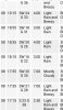
Its nothing to write home about but for 2 -3 hours yesterday we had steady sustained winds between 16 and 24mph with gusts as high as 38. Not damaging it awe inspiring but certainly steady. At the top of the screenshot theres a gust to 36 so the wind kept going for a few more obs.
Attachments
LickWx
Member
You will rebuild . I hope your coworkers in the office are all good . Claimed any FEMA checks yet ?Lost three branches from a crape myrtle.
LickWx
Member
Where Zebulon on that, I bet I beat you!
Wow she really did move right over my place in Raleigh just a bit east of my family’s home in apex. Cheers to that 