BHS1975
Member
Yeap if it gets closer to PR is will be more west.06z still OTS but then0z ensembles still had some members bend back to the coast. The wave has a long elongated circ so not sure exactly where a center will consolidate.
Yeap if it gets closer to PR is will be more west.06z still OTS but then0z ensembles still had some members bend back to the coast. The wave has a long elongated circ so not sure exactly where a center will consolidate.

.png")
It’ll be back for D, J, F, no worries! Winter patterns show their hand in Aug and Sep!It's interesting how we get a -nao attempt right as a storm is approaching to the coast likely to turn it OTS
Oh well, i have cancelled my Andrew vibes. Now im getting 1997 vibes.Euro says stick a fork in this one besides a mostly weak storm with no chance at getting close to landfall with that look at 500mb.
Ha--wish I had a dollar for every time Euro said stick a fork in it....lolEuro says stick a fork in this one besides a mostly weak storm with no chance at getting close to landfall with that look at 500mb.


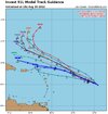
And none based of an official LLC center to initialize on.Some curving and some going west.
The key to it all. And some still headed west.And none based of an official LLC center to initialize on.
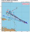
The crazy uncle wants a NE hit.Just when you think it's a done deal, a model separates from the pack and proposes something different.
12z CMC
Even a blind squirrel finds a nut once in a while....lolThe crazy uncle wants a NE hit.

Huge difference between the Euro CMC and the GFS. Based on how wrong the GFS was about the GOM monster then maybe this might be more accurate. At least its something to watch.Probably a miss but umm this thing ain't over just yet. Definitely need to keep an eye on it next few days
What is it about virtually every model at the end of it's range that likes to have hurricanes threatening the east coast?Probably a miss but umm this thing ain't over just yet. Definitely need to keep an eye on it next few days
Might be a early indicator......Euro and CMC switching it up at the same time.Probably a miss but umm this thing ain't over just yet. Definitely need to keep an eye on it next few days
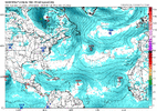
well that northern circulation has fired up new storms so that may become the more dominate feature so who knows!seems a smaller circulation between 17-18N and 53-54 west is fading and we are seeing a much larger far more broad circulation maintaining to the SW.