Brent
Member
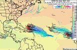
Let's go... Could be our first legit threat
KODLet's go... Could be our first legit threat
KOD?
Yikes.Kiss of death I think. I mean given how the season has been so far.... ?
Yeah I feel this is the one. Both the Euro and the GFS are showing something and when the Euro is onboard, I think this maybe a legit threat


Dorian comes to mind with the stall near the Bahamas of course not expecting the same intensity thoughIm getting an Andrew vibe. If it can survive alot of really bad conditions it may end up in a sweet spot.
Long way to go with this one. Way too early to rule out impacts to the USA
Cmc 12z had the same stutter in the same general area as Euro. The run ran out before turning under the trough. Let's see at 00z.Euro is back to being a significant hurricane and stalls near the NW Bahamas and is trying to turn back towards Florida at the end of the run
Yeah many many possibilities here
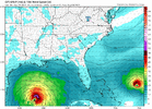
View attachment 121048
Long way to go with this one. Way too early to rule out impacts to the USA
Why is anyone paying attention to any model, ensemble or not, 10 days out when there isn't even an storm yet?
")


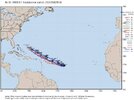
My guess at this point would be OTS, now the fly in the ointment is the consistent weakness/trough over the eastern US does remind me of what happened with Irma. We know how that turned out.12z Euro Ensemble says OTS....

The GFS is very Irma like with the weak ULL over the interior SE.My guess at this point would be OTS, now the fly in the ointment is the consistent weakness/trough over the eastern US does remind me of what happened with Irma. We know how that turned out.
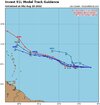
I was told the GFS sucks unless it shows a Cane or snowstorm hitting your house.Is anyone going to mention that the 18z GFS went straight into Myrtle Beach? Reminds me a bit of FlorenceView attachment 121058
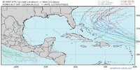
Yeah we are still talking 8-10 days so right now that's the most likely scenario but there's an eternity in model time left.In 00z set, only the Icon leaves it heading west.....the rest are OTS.