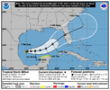
Progged to peak at 120! Also, slower movement expected vs prior forecast.
Tropical Storm Milton Discussion Number 3
NWS National Hurricane Center Miami FL AL142024
1000 PM CDT Sat Oct 05 2024
Milton appears to be slowly organizing. The storm has a central
dense overcast pattern with deep convection persisting near and to
the south of the center. The latest satellite intensity estimates
range from 30 to 50 kt, and based on that data, the initial
intensity is nudged upward to 40 kt. Milton is a small storm at the
moment, with its estimated tropical-storm-force winds extending only
about 30 n mi from the center.
The storm is moving slowly northeastward at 4 kt as it remains
embedded in weak steering currents. However, a shortwave trough is
expected to push southward into the northern Gulf of Mexico. This
trough and a reinforcing one should cause Milton to turn eastward on
Sunday, and move progressively faster to the east and then northeast
across the Gulf of Mexico and Florida during the next 3 to 4 days.
The guidance is in fair agreement, but there is some spread in
both direction and timing. Overall, the models have trended slower
this cycle, and the NHC track forecast has been adjusted in that
direction. This prediction is near the middle of the guidance
envelope and close to the typically best-performing consensus aids.
It should be noted that the average NHC track error at day 4 is
around 150 miles. Therefore, users are reminded to not focus on the
exact track.
Milton will likely steadily strengthen during the next few days as
it moves over the very warm Gulf of Mexico waters, remains in a
moist air mass, and in a diffluent and low to moderate wind shear
environment. The big question is how quickly and by how much will
the storm intensify. There is a big spread in the intensity
models, with the hurricane regional models notably above the
global and statistical-dynamical models. The new intensity
forecast is a little higher than the previous one and in good
agreement with the HCCA and IVCN aids. It is hoped that the models
will come into better agreement tomorrow after ingesting some of the
Hurricane Hunter aircraft observations.
Regardless of the details, there is increasing confidence that a
powerful hurricane with life-threatening hazards will be affecting
portions of the Florida west coast around the middle of next week.
Residents there should closely monitor this system and listen
to local officials.
Key Messages:
1. Milton is forecast to quickly intensify while it moves
eastward to northeastward across the Gulf of Mexico and be at or
near major hurricane strength when it reaches the west coast of the
Florida Peninsula mid week. Hurricane Watches could be issued as
early as late Sunday for portions of Florida.
2. There is an increasing risk of life-threatening storm surge and
wind impacts for portions of the west coast of the Florida
Peninsula beginning late Tuesday or Wednesday. Residents in these
areas should ensure they have their hurricane plan in place, follow
any advice given by local officials, and check back for updates to
the forecast.
3. Areas of heavy rainfall will impact portions of Florida Sunday
and Monday well ahead of Milton, with heavy rainfall more directly
related to the system expected later on Tuesday through Wednesday
night. This rainfall brings the risk of flash, urban, and areal
flooding, along with minor to moderate river flooding.
FORECAST POSITIONS AND MAX WINDS
INIT 06/0300Z 22.9N 95.1W 40 KT 45 MPH
12H 06/1200Z 23.0N 94.6W 50 KT 60 MPH
24H 07/0000Z 23.0N 93.5W 60 KT 70 MPH
36H 07/1200Z 23.1N 92.1W 75 KT 85 MPH
48H 08/0000Z 23.3N 90.5W 85 KT 100 MPH
60H 08/1200Z 23.9N 88.6W 95 KT 110 MPH
72H 09/0000Z 25.3N 86.4W 105 KT 120 MPH
96H 10/0000Z 28.2N 82.3W 95 KT 110 MPH
120H 11/0000Z 30.8N 76.1W 65 KT 75 MPH...POST-TROP/EXTRATROP
$$
Forecaster Cangialosi

