Webberweather53
Meteorologist
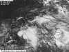
A broad, elongated area of low pressure in association with the central American monsoon gyre continues to gradually organize over the NW Caribbean, and is marked by several bands moderate-deep Cb convection orientated from north-south which have progressively lifted northward over the past several days in response (in part by) anomalous shear vorticity induced by anomalous near-equatorial low level westerly winds generated by the passage of a CCKW and enhanced easterlies underneath a sprawling mid-upper level ridge over the southwestern Atlantic.
NWP is currently split into 2 primary camps on its future evolution with the GFS/CMC favoring a path into the east-central GOM and the southeastern US as a weakness develops between the Azores-Bermuda high over the SW Atlantic and the Four Corners heat Ridge to the west with an area of low pressure consolidating on the northern end of the wave axis, however the other camp lead by the ECMWF/UKMET supports a solution into Mexico/south Texas with a vortex consolidating near/over the Yucatan and Bay of Campeche.
As I mentioned in another thread, while either solution is physically plausible, more credence may need to be given to the ECMWF/UKMET camp given the differential in friction between the Yucatan and adjacent Gulf of Mexico that localizes low level convergence and curvature vorticity induced by the shape of the Bay of Campeche which favors increased low level relative vorticity Bay of Campeche instead of the Yucatan Channel and eastern Gulf as implored by the GFS/CMC. In cases where tropical cyclogenesis attempts to occur along a broad, meridionally orientated wave axis, relative vorticity tends to be maximized closer to the base of the wave (in this instance further south), therefore also favoring the Yucatan Peninsula and BOC vs the Yucatan Channel and SE Gulf. Additionally, it's known that GFS/CMC are notorious for having "sub-vortex scale convective feedback" issues, thus may be erroneously amplifying the northeastern periphery of the CA Monsoon gyre as well as stretching and handing off the low level relative vorticity to quickly into the mid-latitudes, and NWP also tends have profound biases wrt underestimating mid-level heights which only further bolsters the ECMWF solution of a stronger "ridge-bridge" to the north of this system over the Gulf coast...
Regardless, the steering flow is highly uncertain here considering that this system will be stuck in a "col" characterized by a pair of troughs and ridges oppositely juxtaposed to one another relative to the system of interest, and these steering patterns are often highly unstable/unpredictable, thus caution should be exercised when assessing confidence to one particular solution, in spite of the apparently short verification periods. The NHC has given this system a 70% of tropical cyclogenesis in the next 5 days and residents in/around the NW Caribbean, Greater Antilles, Gulf of Mexico, southeastern US, and Mexico should closely monitor its progress over the next several days as heavy rain, wind, and isolated tornadoes will likely accompany it as it moves northwestward into the Gulf of Mexico over the weekend and early this upcoming week.
Here's a schematic representation of a "col", and although the ridge/trough orientation doesn't seem directly applicable to this instance, if rotated 90 degrees, it's very close to what we'll observe over the coming day or two...


For those that want real-time GOES 16 satellite data (which updates every 5 minutes) for this disturbance see: https://weather.msfc.nasa.gov/GOES/

Post away!
NWP is currently split into 2 primary camps on its future evolution with the GFS/CMC favoring a path into the east-central GOM and the southeastern US as a weakness develops between the Azores-Bermuda high over the SW Atlantic and the Four Corners heat Ridge to the west with an area of low pressure consolidating on the northern end of the wave axis, however the other camp lead by the ECMWF/UKMET supports a solution into Mexico/south Texas with a vortex consolidating near/over the Yucatan and Bay of Campeche.
As I mentioned in another thread, while either solution is physically plausible, more credence may need to be given to the ECMWF/UKMET camp given the differential in friction between the Yucatan and adjacent Gulf of Mexico that localizes low level convergence and curvature vorticity induced by the shape of the Bay of Campeche which favors increased low level relative vorticity Bay of Campeche instead of the Yucatan Channel and eastern Gulf as implored by the GFS/CMC. In cases where tropical cyclogenesis attempts to occur along a broad, meridionally orientated wave axis, relative vorticity tends to be maximized closer to the base of the wave (in this instance further south), therefore also favoring the Yucatan Peninsula and BOC vs the Yucatan Channel and SE Gulf. Additionally, it's known that GFS/CMC are notorious for having "sub-vortex scale convective feedback" issues, thus may be erroneously amplifying the northeastern periphery of the CA Monsoon gyre as well as stretching and handing off the low level relative vorticity to quickly into the mid-latitudes, and NWP also tends have profound biases wrt underestimating mid-level heights which only further bolsters the ECMWF solution of a stronger "ridge-bridge" to the north of this system over the Gulf coast...
Regardless, the steering flow is highly uncertain here considering that this system will be stuck in a "col" characterized by a pair of troughs and ridges oppositely juxtaposed to one another relative to the system of interest, and these steering patterns are often highly unstable/unpredictable, thus caution should be exercised when assessing confidence to one particular solution, in spite of the apparently short verification periods. The NHC has given this system a 70% of tropical cyclogenesis in the next 5 days and residents in/around the NW Caribbean, Greater Antilles, Gulf of Mexico, southeastern US, and Mexico should closely monitor its progress over the next several days as heavy rain, wind, and isolated tornadoes will likely accompany it as it moves northwestward into the Gulf of Mexico over the weekend and early this upcoming week.
Here's a schematic representation of a "col", and although the ridge/trough orientation doesn't seem directly applicable to this instance, if rotated 90 degrees, it's very close to what we'll observe over the coming day or two...
For those that want real-time GOES 16 satellite data (which updates every 5 minutes) for this disturbance see: https://weather.msfc.nasa.gov/GOES/
Post away!
Attachments
Last edited:


