WXinCanton
Member
Euro is a good clip east.

HWRF shifts east alot
Yeah I know, whether it strengthens or not, LA/MS/AL will see some real dangerous flooding out of this if this east track happensThat is like the worst possible landfall position for NO.
Even if the more western tracks verify NO is gonna be on the bad side with onshore flow and lets not forget the Mississippi has been in flood for weeks already so i just dont see a good solution here
It’s more about worker safety and precautions that will shut them down. Just a bad spot for storm. I forgot the wind speed criteria over water that they normally shut down for. Don’t think it’s very high.I hope those refineries can hold up under tropical storm wind gusts and heavy downpours!
South-west NC will see direct upslope if current shifts continue or if the GFS is right. Lake Toxaway area.Read these words:
Nobody in the Carolinas is getting rain from this directly after it hits the Gulf. Said it here and now. See this in 5 days. It'll be right.
Yep. Good thing is, it doesn't look like a long-lasting deal with widespread infrastructure damage. So hopefully, any spike in prices will be relatively short-lived.It’s more about worker safety and precautions that will shut them down. Just a bad spot for storm. I forgot the wind speed criteria over water that they normally shut down for. Don’t think it’s very high.
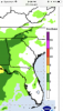
But could be a multi-day shutdown based on track-speed. Just checked the NHC rain map and they have 4-6” smidge over western NC now.Yep. Good thing is, it doesn't look like a long-lasting deal with widespread infrastructure damage. So hopefully, any spike in prices will be relatively short-lived.
Agree.... however already reports of evacuations from oil rigs in the GOM and those same reports say some 250,000 barrels a day immediately affected with a potential for 700,000 barrels a day. So yeah hopefully short lived but gas price increase not out of the question unfortunatelyYep. Good thing is, it doesn't look like a long-lasting deal with widespread infrastructure damage. So hopefully, any spike in prices will be relatively short-lived.
Agree.... however already reports of evacuations from oil rigs in the GOM and those same reports say some 250,000 barrels a day immediately affected with a potential for 700,000 barrels a day. So yeah hopefully short lived but gas price increase not out of the question unfortunately