CoreyTheSecond
Member
I think the wedge will break. Just give it some time. Breaks in the cloud cover are coming for Atlanta.
Interesting that area of moderate rain holding together and making it's way into western NC, I'm actually concerned about a boundary setting up across our area b/c of that which could provide a focal point for rotating storms. Unless the wedge scours out completelyI would think as soon as the rain ends the wedge will erode from SW to NE but you never know
They did say by 3:00 pm so they have 15 minutes.... LolSPC is taking their sweet time getting this watch out good grief
It's coming out now but good grief let's go chop chopThey did say by 3:00 pm so they have 15 minutes.... Lol
where is here?Don't like the wording for here
Sent from my SM-S820L using Tapatalk
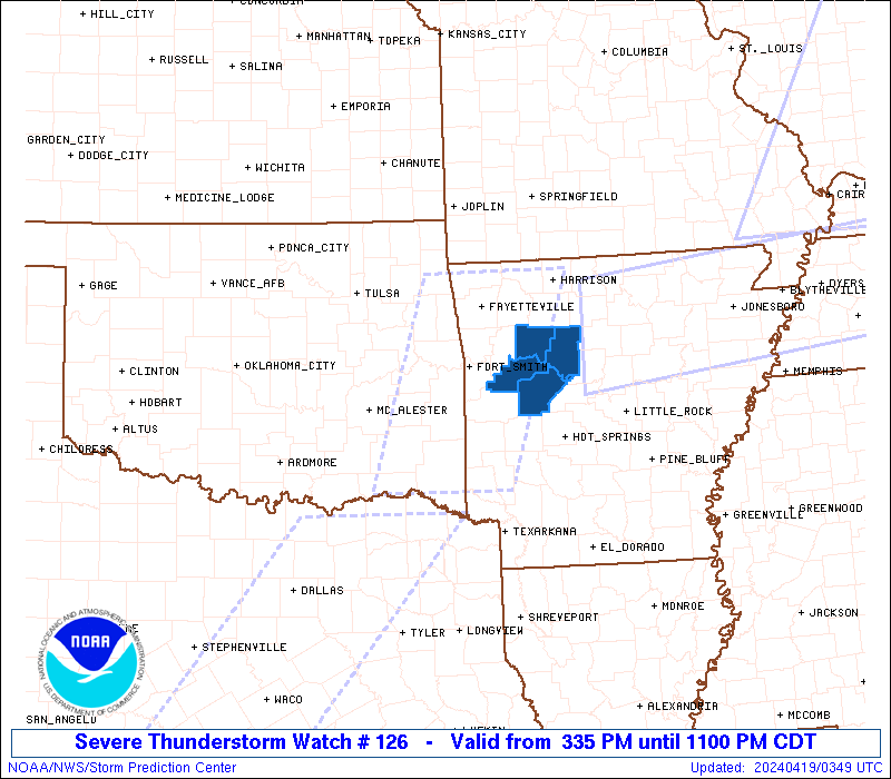

That's one small watch box.Tornado Watch 126
Public | Counties | Probabilities | Aviation | Warnings | Initial RADAR
Hazard Watch Status Reports.
WOUS64 KWNS 051842
WOU6
BULLETIN - IMMEDIATE BROADCAST REQUESTED
TORNADO WATCH OUTLINE UPDATE FOR WT 126
NWS STORM PREDICTION CENTER NORMAN OK
245 PM EDT WED APR 5 2017
TORNADO WATCH 126 IS IN EFFECT UNTIL 800 PM EDT FOR THE
FOLLOWING LOCATIONS
NCC017-047-155-060000-
/O.NEW.KWNS.TO.A.0126.170405T1845Z-170406T0000Z/
NC
. NORTH CAROLINA COUNTIES INCLUDED ARE
BLADEN COLUMBUS ROBESON
SCC031-033-041-043-051-067-069-089-060000-
/O.NEW.KWNS.TO.A.0126.170405T1845Z-170406T0000Z/
SC
. SOUTH CAROLINA COUNTIES INCLUDED ARE
DARLINGTON DILLON FLORENCE
GEORGETOWN HORRY MARION
MARLBORO WILLIAMSBURG
This ain't Texas...it's how we roll. Lol actually looks like just basically an extension of the previous watchThat's one small watch box.
Another massive watch area and imho I think we end up with more storm reports out of this area then the current PDS Watch area (not knocking SPC by any stretch) just seems this area is primedNew watch
Sent from my iPhone using Tapatalk
New watch
Sent from my iPhone using Tapatalk
Not out of the woods until the front passes. Unfortunately I still see the worst has yet to come.That light rain that developed is really holding this back from being as dangerous as it could've been in the eastern areas in Georgia...
There were severe thunderstorms that developed, but it is not as bad as it could've been.
Not out of the woods until the front passes. Unfortunately I still see the worst has yet to come.
If it's gonna develop it better hurry up
Sent from my iPhone using Tapatalk


yep the CU field is developing but still need a little kick. Most models didn't have a second line really getting going until about halfway across AlIf it's gonna develop it better hurry up
Sent from my iPhone using Tapatalk
