Phillip l
Member
Sounds like music to my ears.MOB calling for mainly a hail threat with the last round
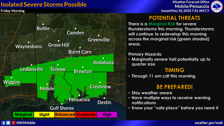
Sounds like music to my ears.MOB calling for mainly a hail threat with the last round
Latest HRRR .....I imagine a watch will be coming soon


Sent from my iPhone using Tapatalk
That's terrible.... any details?Damn horrible damage reports out of Americus Georgia
http://www.walb.com/story/35072749/first-alert-live-now-tornado-watches-and-warnings-in-swgaDamn horrible damage reports out of Americus Georgia
I'd say from Huntsville down south of Birmingham . Hail and strong winds the biggest threat in those areas but it will be a tornado watch no doubt due to the increased threat for eastern AlabamaWhat areas are you thinking?
I'd say from Huntsville down south of Birmingham . Hail and strong winds the biggest threat in those areas but it will be a tornado watch no doubt due to the increased threat for eastern Alabama
Beginning to hear thunder rumble in the distance, it may not have strengthened into anything big yet but those rain patches in central Georgia have turned into thunderstorms...

Warm front pushed thru here in SE TN...temp has went from 54.6 to 72.2 and dp went from 52.1 to 62.8 in the last hour and a half.
Sent from my SM-S820L using Tapatalk

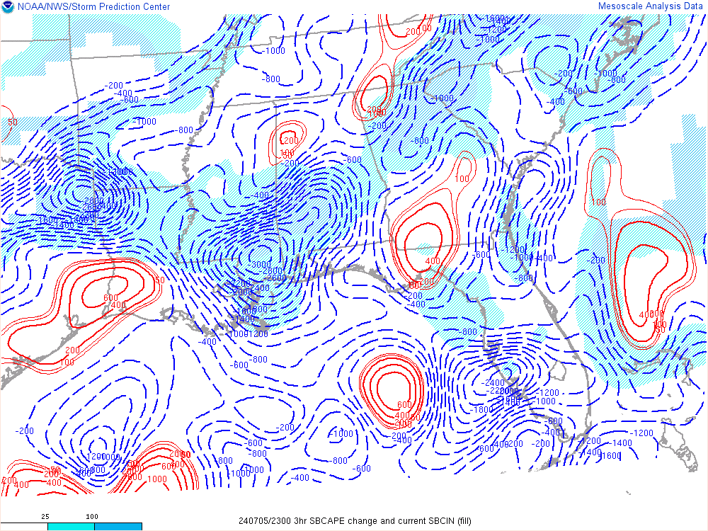
Dryline is near the MS/AL state line now. Columbus, MS dewpoint down to 57.Will be interesting to see how the dry line interacts with leftover boundaries left from this morning
Watch coming
Sent from my iPhone using Tapatalk
It's still further back towards central Mississippi per mesoscaleDryline is near the MS/AL state line now. Columbus, MS dewpoint down to 57.
Don't like the wording for hereWatch coming
Sent from my iPhone using Tapatalk
Don't like the wording for here
Sent from my SM-S820L using Tapatalk
This shows it perfect. Hit play at the bottomIt's still further back towards central Mississippi per mesoscale
Yep, I would think that corridor will start to fire and start to fill in.We have returns in Eastern Mississippi and west of Nashville . Whatever is gonna fire is starting
Yeah it's great after the disaster when we first started that now our server space is through the roof and can handle anything. But your right the live feed is amazingI will say the live thread option has been great, I've just left my browser open all day and checked in periodically.
Word.I will say the live thread option has been great, I've just left my browser open all day and checked in periodically.
how's the cape looking now? Still increasing?

I would think as soon as the rain ends the wedge will erode from SW to NE but you never knowDamn at that wedge...something's gotta give though. Like DeltaDog says- Never bet against the wedge; because you WILL lose every time
Unless the sun comes out...Damn at that wedge...something's gotta give though. Like DeltaDog says- Never bet against the wedge; because you WILL lose every time
IMO the day has gone spot on what we thought except for the people worrying about the wedge lol . Even there the warm front is on the move againDoes it look like more of N AL (West and East) could get more of a punch that originally thought?


