Been watching that one as well. Seems like it’s struggling but like the MD says the next 1-2 hours may tell the story if there’s an uptick in intensityDon’t love the look of this cell. Looks like it’s going to track right through metro ATL if it holds together.
-
Hello, please take a minute to check out our awesome content, contributed by the wonderful members of our community. We hope you'll add your own thoughts and opinions by making a free account!
You are using an out of date browser. It may not display this or other websites correctly.
You should upgrade or use an alternative browser.
You should upgrade or use an alternative browser.
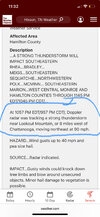
Severe Severe Threat 3/31-4/3
- Thread starter SD
- Start date
Psalm 148:8
Member
- Joined
- Dec 25, 2016
- Messages
- 345
- Reaction score
- 792
Am I missing something?? I just don’t see this enhanced risk verifying in Al/Ga from what I see now.
Snow_chaser
Member
Am I missing something?? I just don’t see this enhanced risk verifying in Al/Ga from what I see now.
Doesn’t even look like there’s alot of lightning in what’s out there.Am I missing something?? I just don’t see this enhanced risk verifying in Al/Ga from what I see now.
Brent
Member
Am I missing something?? I just don’t see this enhanced risk verifying in Al/Ga from what I see now.
Yeah I've been watching because it's close to my parents but there's just nothing there. Storm mode is way too junky
Wouldn’t be surprised to see a tornado warning issued for the obvious bookend vortex over Marion county soon. That could drop a weak tornado in a hurry.
- Joined
- Jan 5, 2017
- Messages
- 3,802
- Reaction score
- 6,051
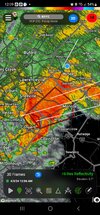
Perry County, AL has a very suspicious cell located there. Quickly moving in to Chilton and Dallas counties.
- Joined
- Jan 5, 2017
- Messages
- 3,802
- Reaction score
- 6,051
Tornado warned now.Perry County, AL has a very suspicious cell located there. Quickly moving in to Chilton and Dallas counties.
Tornado warning now for that cellPerry County, AL has a very suspicious cell located there. Quickly moving in to Chilton and Dallas counties.
TOG now.
Never sleep on bookend vortexes in setups like this.
Never sleep on bookend vortexes in setups like this.
CC drop 
Triplephase93
Member
Brent
Member
Was definitely a spinup for a few frames
Probably gone now. On east will deal will it again in the next hour or so.
Edit: then again it may still be down looking at CC.
Edit: then again it may still be down looking at CC.
SnowwxAtl
Member
What area is this?
Brent
Member
What area is this?
Between Selma and Clanton
SnowwxAtl
Member
Question, do yall think this rain junky/messy will help ATL tonight. Make the atmosphere more stable or no?
Brent
Member
Question, do yall think this rain junky/messy will help ATL tonight. Make the atmosphere more stable or no?
It's definitely encouraging the convection is junky which probably keeps the really big threat down but you can always have these quick spinups like we just saw
SnowwxAtl
Member
Gotcha. Thank youIt's definitely encouraging the convection is junky which probably keeps the really big threat down but you can always have these quick spinups like we just saw
- Joined
- Jan 5, 2017
- Messages
- 3,802
- Reaction score
- 6,051
It might. The cell south of Atlanta dropped .50" of rain rather quickly and my temp is down to 65.7 with a dewpoint of 64. Still too humid for my liking, though.Question, do yall think this rain junky/messy will help ATL tonight. Make the atmosphere more stable or no?
- Joined
- Jan 5, 2017
- Messages
- 3,802
- Reaction score
- 6,051
Athens, GA needs to pay attention to that cell that just moved through here.

Athens, GA needs to pay attention to that cell that just moved through here.

Cc drop in Conyers 
Brent
Member
Something just crossed 20 near Conyers for sure
Good eye. Man that wrapped up fastAthens, GA needs to pay attention to that cell that just moved through here.
Windergawx
Member
Rotation with the book end is weakening over Coosa county. Probably the next threat area will be Kellyton/New Site.
Windergawx
Member
23% of customer out of power in Rockdale
2.4 inches of rain in an hour at KATL with that cluster of storms earlier

Almost none here, that cluster down there did look intense.2.4 inches of rain in an hour at KATL with that cluster of storms earlierView attachment 147307
- Joined
- Jan 5, 2017
- Messages
- 3,802
- Reaction score
- 6,051
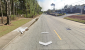
This crushed storm drain might have something to do with it.
Attachments
SnowwxAtl
Member
I live 5 minutes away from this area. Yea it is very flood prone. Very bad and poor drainage system on that road!This crushed storm drain might have something to do with it.
- Joined
- Jan 5, 2017
- Messages
- 3,802
- Reaction score
- 6,051
It's pouring here! Big rains but no wind. Some close lightning strikes. About 1.2" so far.
SnowwxAtl
Member
I want to go to bed @weatherfide, I am in College Park so we are experiencing the same thing. Luckily, this is the last hooray of this storm!It's pouring here! Big rains but no wind. Some close lightning strikes. About 1.2" so far.
