StoneColdHeel
Member
WRAL saying the main threat here in the Triangle will be between 9 AM and 2 PM tomorrow, and most of the rain should be out of here by then.
Yeah if that verifies this won’t be much of an issue18Z 3K NAM has almost no surface based CAPE at my location during the event.
Certainly wouldn't warrant a hatched enhanced risk, in my opinion. This will be the second time this year that SPC got it way wrong in my area, if it verifies. To be honest, most of the model guidance, once again, were predicting a weaker environment for severe storms. I mean, the surface low is in Michigan. That's usually an Ohio Valley threat.Yeah if that verifies this won’t be much of an issue
Sounds right, I’m seeing 81° in Dallas and sun is poking outAccording to my Weather station at my house in West Paulding County its 79 and jumped up 8 degrees in 2 and half hours
On cue the HRRR at 19z goes back to much more cape and higher tornado ingredientsCertainly wouldn't warrant a hatched enhanced risk, in my opinion. This will be the second time this year that SPC got it way wrong in my area, if it verifies. To be honest, most of the model guidance, once again, were predicting a weaker environment for severe storms. I mean, the surface low is in Michigan. That's usually an Ohio Valley threat.
 love model watching. We will see how it plays out

I live in southeastern Bartow County and radar currently shows showers over me. But I haven’t seen so much as a sprinkle, and in fact there is sunshine peeking out of the clouds at the moment. I’ll admit, the periodic sunshine we’ve seen this afternoon has me concerned about later tonight.Anyone in north Georgia confirm whether what’s showing on radar is reaching ground? Maybe early shower could help stabilize things alittle?
Way too early for this man. Let's check back around 10-11pm. Just takes a couple of storms to get going and this was always going to be an after dark threatI think...and I said I think now...this is going to be a bust for GA! This storm does strike me as the one!
Gotcha JRIPS27, that is why I said I think...I am probably wrong but like you said, we will check back around 10p tonight.Way too early for this man. Let's check back around 10-11pm. Just takes a couple of storms to get going and this was always going to be an after dark threat


Nothing even remotely close, IMO.I hope this tornado outbreak isn’t as bad as the one that happened exactly 50 years ago on April 3. 1974.
Not sure this can even be called an outbreak. Granted there is still a chance but I’m not seeing this popping off.Nothing even remotely close, IMO.
Welp we haven't had a moderator action since 12:54 when I changed around some of the pinned threads sooooAdmin? Why was My post removed?
Our storms probably have not even formed yet. This reminds me of maybe a weaker version of November 2002 or March 2012 when things really only got going after dark in Alabama and Georgia. Our storms should start to appear around 9 pm or so. GSP is certainly not backing off and if they are right, it would take just 1 cell to cause major problems since they seem to think the storms may follow I-85. That would put Greenville and Spartanburg in play.Way too early for this man. Let's check back around 10-11pm. Just takes a couple of storms to get going and this was always going to be an after dark threat

Bouncycorn's Storm-NET model is going nuts with that system.Don’t love the look of this cell. Looks like it’s going to track right through metro ATL if it holds together.
View attachment 147296

The area that has no Tornado watch as of yet!HRRR still highlighting the 20/85 corridor in GA for enhanced rotation potentialView attachment 147298

That’d be the oneView attachment 147299
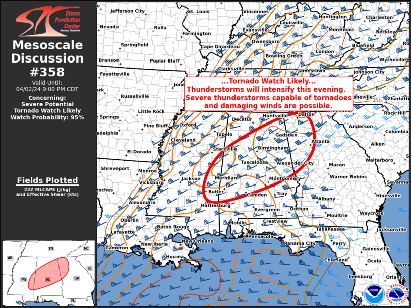
SUMMARY...A cluster of strong thunderstorms over west-central AL may
intensify in the next hour or two, posing a risk of a few tornadoes
and wind damage.
DISCUSSION...A cluster of thunderstorms that formed over southeast
MS has now moved into west-central and southwest AL. The air mass
ahead of these storms continues to moisten with dewpoints in the mid
60s now as far north as BHM. Meanwhile, an intensifying southerly
low-level jet is focusing across southern/central AL as shown by
regional VAD data. Recent hodographs from the BMX/MXX/EOX radars
show large, looping shear profiles with 0-3km SRH values of 300-400
m2/s2. 00z RAOBs from BMX/FFC showed a deep warm-layer from 0-4km,
that has thus far limited updrafts strength. However, model
guidance suggests this layer will cool somewhat in the next 1-2
hours, allowing more robust convection. Both the HRRR and recent
WoFS runs show the corridor from the current storms eastward to the
south of the BHM area toward the western ATL suburbs as having a
relatively greater threat in the next few hours for severe storms
including a few tornadoes.