NBAcentel
Member
Chris Justus sounds like he thinks we're gonna see some tornado warnings start popping up
Somewhat the same with brad
Chris Justus sounds like he thinks we're gonna see some tornado warnings start popping up
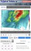
That cell is Chatham Co needs to be watched closely, small hail core and has shown signs of weak rotation.Tornado warning for mount airy
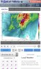
Yep not very strong couplet but one none the less, a quick hitting rain wrapped spin up could still cause problems obviouslyTornado warning for mount airy
Close again, just passing to my west a few miles.......Tornado warning for mount airy


Think your safe! Tornado watch fail!I’m headed home from Atlanta. Did even rain at home? @Tarheel1

I think the bad stuff is suppose to roll in about 7 tonight. Sun is popping out and with as much cape as we have that’s not a good thing.Think your safe! Tornado watch fail!View attachment 19028
I just thought all the moderate rain I’ve had, would work over the air? GSP says models are concerning, but lack of radar development, gives them pauseI think the bad stuff is suppose to roll in about 7 tonight. Sun is popping out and with as much cape as we have that’s not a good thing.
I think the bad stuff is suppose to roll in about 7 tonight. Sun is popping out and with as much cape as we have that’s not a good thing.
Could the models be wrong? Sure they are wrong all the time about snow. But if you walk outside you can just feel the air. I would still bet on storms rolling through later tonight.I just thought all the moderate rain I’ve had, would work over the air? GSP says models are concerning, but lack of radar development, gives them pause
And here it startsHrrr still says there will be a round 2
Sent from my iPhone using Tapatalk

The thing that's going to be most worrisome going forward in the areas that clear for a while is the storms that are starting to develop in Georgia based off radar. Will there be enough there for them to rotate?
Had a gust of 33mph here earlierThe new Nam and HRRR are worrisome ... I’m already seeing very strong winds outside in any thunderstorm here at UNCC campus .. models seeing what looks to be a squall line of maybe even super cells .. check of the difference the 18z Nam is in regards to wind gust parameters than the 12z was in a short matter of time