Shaggy
Member
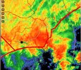
3k nam.is stronger at 0z than just about any other run

I always pay close attention to the outflow to as it will give you a good indication of where the center will heads towards. The outflow is clearly moving NW.It could be deceptive since it’s based on the IR satellite loop, but it sure looks like this is not drifting NW like a lot of the model guidance had suggested about now. It almost looks like it may be moving NNE, but that could be the IR fooling me and this may be due to shearing. But if so, that should favor a NC rather than the SC that the GFS/Euro have.

I can't stress how hard it's raining in Wilmington
Spinups showing up in that band to the east of the center. Wherever that rotates onshore should see some tornado warnings
Winds really picked up last 20 or 30 minutes here.Sporadic lightening and thunder, with I'd estimate near 30 mph gusts here. Core of the storm is approaching pretty quick hoping for no Tor.
Wow look at Kure
Kure Beach NC Surf Report Webcam and Weather - SurfChex.com
Kure Beach live HD web cam and surf report and live weather conditions. Watch our live Kure Beach HD surf cam and weather conditions updated every second.www.surfchex.com
Strengthening gradient should bring some decent gusts into the 30s inland today. I guess the drought around here is pretty much gone now.Winds really picked up last 20 or 30 minutes here.
At the airportWinds really picked up last 20 or 30 minutes here.
| Humidity | 93% |
| Wind Speed | N 29 G 45 mph |
| Barometer | 29.87 in (1011.5 mb) |
| Dewpoint | 68°F (20°C) |
| Visibility | 2.50 mi |
| Last update | 16 Sep 8:52 am EDT |
Been gusting low 40s here highest recorded at ILM is 45mph so far. Rain is nuts thoughStrengthening gradient should bring some decent gusts into the 30s inland today. I guess the drought around here is pretty much gone now.
Like being in a heavy thunderstorm for 5 hoursThe Last *BAND*,, If you can call it that.. We are in a "Lull" currently..
I had too take the Step~Daughter too work in Surf City..
Lotsa Thunder & lighting, indictive of a organizing TS/TC?
The Ocean @ Surf City pier looked like a Mud Washing Machine.. waves 10' plus..
(Yeah went by there)..
I wouldn't be surprised that Condo buildings on N. Topsail get condemned after this, even w/the Sandbags in place.
Anyhoo..
Wind(s) are outta the North @22mph, gusting 35 & 40 just Shy of (solid), TS force winds
I've gotten ALOT of Rain since 12AM this morning over a couple inchs approaching in my AO, approaching 3.50 on My rain Guage.. Since yesterday 12pm ..
Looking at the Radar, I can only Guess, what @Shaggy & @lexxnchloe are getting in Wilmington, Solid RED On the Gaydar..
Almost like Floyd when that made landfall..
Winds aren't crazy but causing a lot of misting off the roofs and sideways rain it is like being in a strong thunderstorm for an hour straight. I'd say this has been worse than Debby so farLike being in a heavy thunderstorm for 5 hours
Meanwhile new hanover county where the worst of this is hitting did not cancel lolThey called school for this in Charleston (eLearning day) and the sun is coming out. Of course
Brad P reposted a tweet with a pic from Southport with a community with 15" at the time. Might hit some Matthew type numbers that way.17 inches of rain down at Kure Beach and they may easily go over 20 inches
Waves are calm tbh hereThey called school for this in Charleston (eLearning day) and the sun is coming out. Of course

This is about to pass me