D
Deleted member 1449
Guest
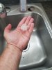
Nearly golf ball sized hail in Kernersville 

Wow! Impressive! Curious if you or anyone else in the area is seeing any signs of a lower hanging, rotating wall cloud w/ this thing? What I'm seeing via KRAX seems to suggest there's broad rotation at least in the low-mid levels.Nearly golf ball sized hail in Kernersville View attachment 19962
I'd be much more concerned if we didn't have that area of storms off to the west along the front side of the forcing. Now if that stuff starts to die off we are in troubleLooks like the ol' 7-10 split for central NC this evening.
Maybe a slight semblance of a wall cloud as it approached...nothing remarkable that I saw.Wow! Impressive! Curious if you or anyone else in the area is seeing any signs of a lower hanging, rotating wall cloud w/ this thing? What I'm seeing via KRAX seems to suggest there's broad rotation at least in the low-mid levels.
Maybe a slight semblance of a wall cloud as it approached...nothing remarkable that I saw.

Agreed there are at least a couple if low level boundaries going W to E across the state and a strip of higher instability as well. I feel like we probably see that stuff to our west congeal over time into a line that moves through.Unlike yesterday, the progress of this slowly northward propagating outflow boundary extending along a line just north of Raeford, Fayetteville, Clinton, & Mt Olive may actually be worth watching later in the evening as a locus for t'storm development &/or intensification in east-central NC especially considering that storms have been firing along it at will around Kinston and Greenville.
Strongest storm on radar definitely appears to be practically over Piedmont-Triad International & headed in the direction of Greensboro.
View attachment 19960


")
Right over the house too.....Major outflow boundary collision about to occur near SD.
The blank job indicator is lit.I'd be much more concerned if we didn't have that area of storms off to the west along the front side of the forcing. Now if that stuff starts to die off we are in trouble
Sent from my SM-G955U using Tapatalk
In full effectThe blank job indicator is lit.


Best looking storm so far today. Got any pics of that shelf?Gotta be a nice wall cloud with this
Sent from my SM-G955U using Tapatalk
I'm trying to get mom and dad to go out and lookBest looking storm so far today. Got any pics of that shelf?

Speaking of a 7/10 split....Looks like the ol' 7-10 split for central NC this evening.

Splitting supercells for the winSpeaking of a 7/10 split....
Sent from my SM-G950U using Tapatalk
Splitting supercells for the win
What you see that I don't? I keep watching the Wilmington radar to see the updrafts getting started along the outflow and nadaSD is about to hit the jackpot
Well you’re about to get underneath the hook on KRAX so you’ll probably have a decent look at whatever is left of the wall cloud this presumably hasWhat you see that I don't? I keep watching the Wilmington radar to see the updrafts getting started along the outflow and nada
Sent from my SM-G955U using Tapatalk
It was probably your stomach growling.One rumble of thunder is all I have had so far.