Looks like a typical Nino! Dry and warm up here! 


Looking at the Teleconnections update today, it looks like the PNA is going to be basically neutral from later this week through the middle of the month before making going up a bit after that… however the AO and NAO also look like they will stay neutral to slightly positive at that point as well. As for the 2009-2010 analog… keep in mind that there was a lot of mild weather for November and the first half of December that year with just several quick cold shots. It took until mid December to start really setting up any blocking09/10 anallog! Boom ? View attachment 137706
I really don’t want to waste all my snow chances in November, with marginal temps! I’m good with some kind of good pattern setting up for all of us in December and going forward!Looking at the Teleconnections update today, it looks like the PNA is going to be basically neutral from later this week through the middle of the month before making going up a bit after that… however the AO and NAO also look like they will stay neutral to slightly positive at that point as well. As for the 2009-2010 analog… keep in mind that there was a lot of mild weather for November and the first half of December that year with just several quick cold shots. It took until mid December to start really setting up any blocking
09/10 anallog! Boom ? View attachment 137706
How was 09-10?If we could only be so lucky
I'm still very concerned about wasting winter early again
True there was an ice storm here in October 2020 and that was a good winter but otherwise the analogs suck largely
I’m gonna speak on Iowa, I heard it was a memorably snowy and cold winter here , and the Carolina’s did ok too! One they will tell their grandkids about!How was 09-10?
Imo best winter we had in the last 15 years with consistent cold and storminess. The 13-14 winter was impressive however as well. Very very close second imoHow was 09-10?
February 2014 was cold in the Mid-Atlantic.Imo best winter we had in the last 15 years with consistent cold and storminess. The 13-14 winter was impressive however as well. Very very close second imo
How was 09-10?
Sounds like almost everyone in this forum would kill for another 09-10.One of the snowiest winters on record here with a blizzard on Christmas Eve. I would kill for even the last part ?
Even in Alabama where I was it was one of the best winters I remember. Dallas had a foot of snow in February 2010 also
Sounds like almost everyone in this forum would kill for another 09-10.
Good because I got Poop from that awful storm. 31 and rain for hrs.Western/northwestern suburbs of Atlanta got a foot of snow back in 2018 surprisingly. We forget about that.
Good because I got Poop from that awful storm. 31 and freezing rain for hrs.
No it was cold rain and heavy cold rain.I corrected it for you buddy?
Good because I got Poop from that awful storm. 31 and rain for hrs.
That when Chipper jones rescued Freddy Freeman from the highway?Yeah probably the closest thing we've had to a board wide good winter
13-14 was good too(when Atlanta famously was crippled by an inch of snow #neverforget) but dang


? no need to be bullseyed right now ?

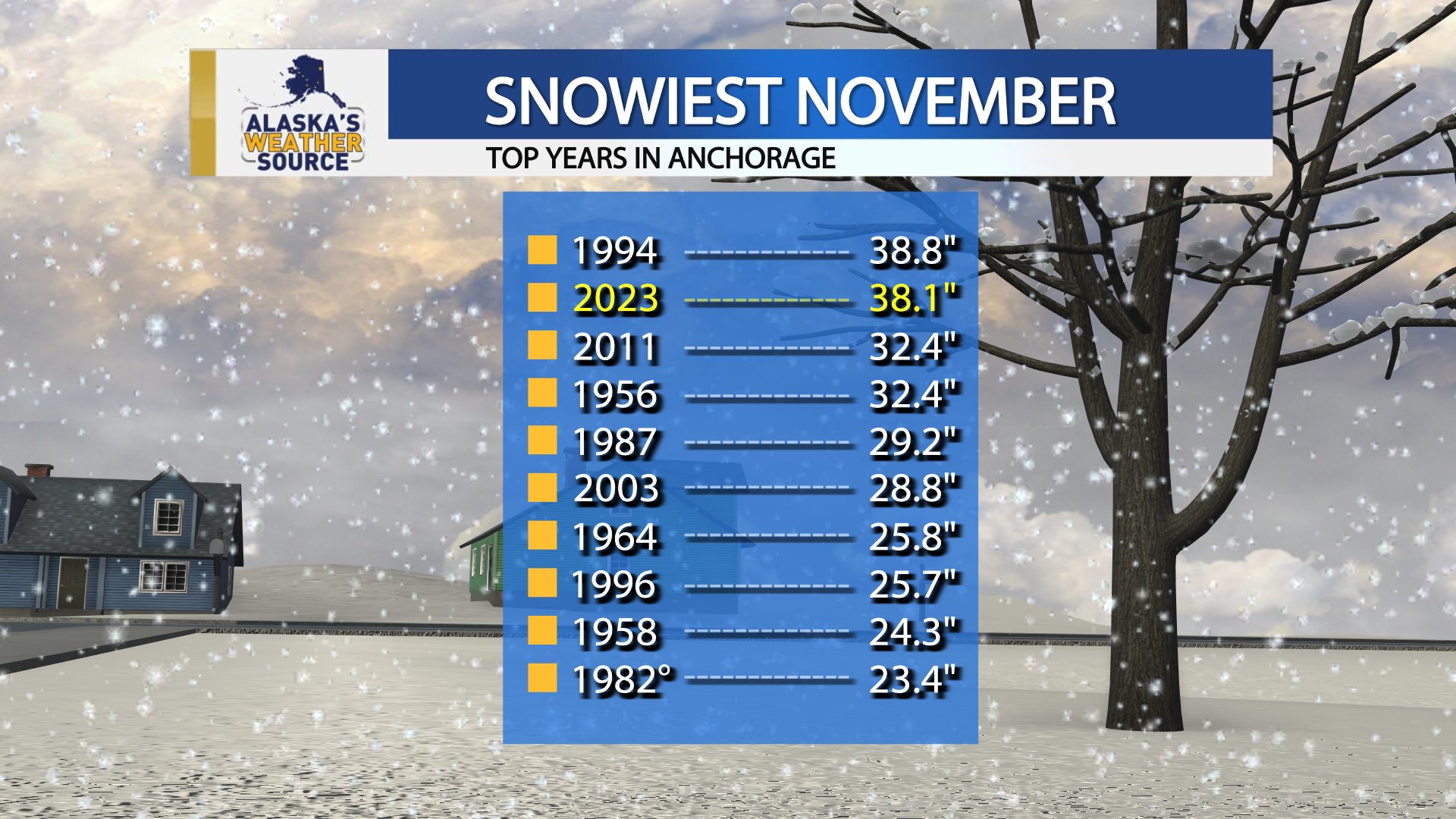
Nobody cares Mack truckInteresting….View attachment 137882
Haters gonna hate! I’m just shake it offNobody cares Mack truck


Most of those years sucked here lol
I mainly posted it because of my 1982 analog to this year


Yeah man, getting an early start! ?
 ️
️