Getting to that time of year where we start seeing long duration rain events for whenever we do see rain .. depression season lol
Wait, this is just starting?
Getting to that time of year where we start seeing long duration rain events for whenever we do see rain .. depression season lol
Getting to time of year where we get more stratiform rains.Getting to that time of year where we start seeing long duration rain events for whenever we do see rain .. depression season lol
Time for a mile wide broken band to come through and deliver hope for rain that wont come to fruition.
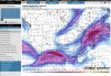
Y’all might get the moisture from Pamela at the end of the week??The front has all the makings of one of those pencil thin lines with some trailing showers as the 85-7 trough lags behind the sfc front/pft. Probably only a .05-.2 type event. If we get the deeper trough next week we get a more significant rain event
Maybe western parts of the region. That stuff gets really strung out and diffuse but the time it gets hereY’all might get the moisture from Pamela at the end of the week??
Still solid fall weather with maybe a couple mid 70 days but even that is a relief from mid 80s at this time of year .. few points should be lower .. I think we can kiss the super uncomfortable days goodbye for now


I do like the big high on the euro spreading into the plains. Don't like the big ridge Amp from the rockies into Canada and the fractured trough... that's a recipe for a cutoff and warm/muggy if we didn't wedge or get a clean troughEuro trying to find a way to find a warmer period, noticed this on the 12Z EPS yesterday but didn’t think much of it, per this look it would be transient tho View attachment 92508View attachment 92509View attachment 92510


A little back and forth classic fall time weather. About time we get back to normal around here. That cold shot behind this will probably be more intense then our first oneFeels like we’re seeing this look for a reason repeatedly pop up View attachment 92515View attachment 92516
Close to turning it into a cutoff that gets stuck to our westA little back and forth classic fall time weather. About time we get back to normal around here. That cold shot behind this will probably be more intense then our first one
Yeah certainly too early to know the specifics but if that happens we could certainly see some severe prospectsClose to turning it into a cutoff that gets stuck to our west
Cold cold rainWhat a look if it were January.
Cold cold rain
Insert the pattern in October sometimes likes to mimic winter patterns commentWhat a look if it were January.
The one time I got to experience a snowfall before Thanksgiving was in November 2000… I had 4 inches in Concord where I was living at the time, and then never got more than flurries the rest of the winterGotta love the 600+ hour European … unfortunately can’t be trusted but I’ll take it for now as it’s showing what I’ve been thinking could happen for a while with an early start to winter with the help of that early strat warming taking into effect much earlier than we usually get … haven’t had a thanksgiving flurry in a while ??
That was a great event full on mashed potatoes falling. Could have been an awesome 2 week period if the coastal low didn't miss east in early DecemberThe one time I got to experience a snowfall before Thanksgiving was in November 2000… I had 4 inches in Concord where I was living at the time, and then never got more than flurries the rest of the winter
You're antisocialThat was a great event full on mashed potatoes falling. Could have been an awesome 2 week period of the coastal low didn't miss east in early December

It would literally be an antisocial winter. Just like 2018-19.Some type of SSW event is our only chance to see a possible cold start to winter. A weaker pv for sure. Dont want it too early either because, imo, it's tough to see a sustainable cold pattern to produce snow and ice in the south and se other than your typical favored higher elevations