• Hello, please take a minute to check out our awesome content, contributed by the wonderful members of our community. We hope you'll add your own thoughts and opinions by making a free account!

Pattern November Knock-Out

Sign me up buttercup
After last year I am loathe to get my hopes up this soon in the game, but those model runs are absolutely

tenor.gif
 
The GEFS is predicting a sub -3 AO in a few days. That has happened in about 20% of Novembers since 1950. Here are the other Novembers with a day or more of sub -3:

2010, 2002, 2000, 1998, 1985, 1984, 1972, 1968, 1965, 1962, 1959, 1955, 1952, 1950

After throwing out El Ninos and warm neutral, we're left with these 8: 2010, 2000, 1998, 1985, 1984, 1962, 1955, 1950
Of these 8 Decembers in the SE US, 5 were very cold (2010, 2000, 1985, 1962, 1950), one was cool (1955), and 2 were quite warm (1998, 1984).

Of these 8, the closest ENSOwise to 2017 appear to be these: 2000, 1984, and 1950
Of these 3 Decembers, two were very cold (2000 and 1950) and 1 was quite warm (1984).

Conclusion: For cold 3.4 ENSO, there appears to be a small correlation between a November with a day or more of -3 AO and a quite cold Dec. in the SE US. I think it is safe to hypothesize this small correlation because the only other very cold SE Dec. with cold ENSO was 1983 and even it had a -2.510 AO day in Nov. Here's hoping.
Good research Larry. I am looking forward to the next few weeks. It's been a while since we have had such a good blocking signal.
 
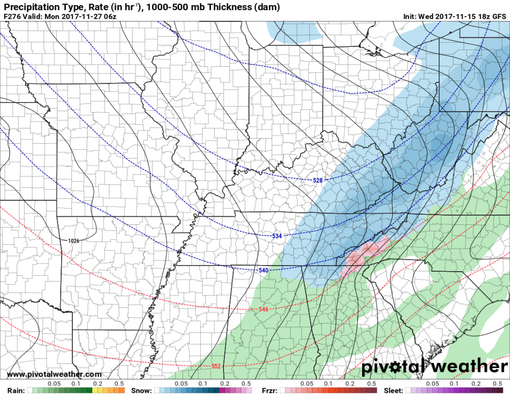
LR GFS FWIW is still looking great going into Thanksgiving and after. Strong blocking continues to show up and it's real close to a phased system on the 28th...
875c2c4ba1e37d9c28db7bc440b0105b.jpg
e6967a06a21fb39c0b7819b0befd50ed.jpg
2504c6e1e2eaf1235c35a3d1ed52f97c.jpg
a682793e3a5d03d43f1665f22656aaf3.jpg
d5bae160a7a50b1d0ae49421f9320e14.jpg


Sent from my SM-N950U using Tapatalk
 
look chilly, slightly BN to me.. we'll see how that 'mega-block' works out after Thanksgiving. They call it voodoo country for a reason.
 
gfs_mslp_pcpn_frzn_us_31.png
Pretty darn close, if that low came little north. End of run COLD!!!
 
06z GFS trying to catch on what the Euro was showing I see with placing a low to the south. From that run this morning of the GFS, that looks like it may turn out to be an over running event. A low comes up along the front. As always, we'll see how it plays out.


e0ef33283042c7714d11417b756c3e79.gif


Sent from my SM-J327T1 using Tapatalk
 
Good to see gulf lows and cold air around hopefully setting the trend for winter. Snow in December seems like a much more likely scenario than November for sure.
 
La Nina's can be very front loaded in some years and just plain ugly in some. I would love to see the SST charts for those years and look at the Pacific placement of the coldest water (relative to the averages) as a good metric to look and see what if any difference it makes with this type of weak La Nina
 
Would love another December like 2010.
Me too. It's been years since we have had a cold December. I remember one year it was so cold it snowed about a couple weeks before Christmas and was still on the ground in some places Christmas morning. We are way overdue.
 
I bet a good portion of the SE will see snow by next month if the trends keep up. Cold rain is part of a colder pattern so there will probably be some days like that as well.
Also, good chance as the cold blast comes through shortly after thanksgiving, we could see a storm somewhere end of month or beginning of December.
 
Not saying anything new, but the short term trend continues ...

sfc_count_sup814_temp.gif


Just hoping that it doesn't all erode once winter actually gets here ...
 
Back
Top