TORNADO OR SEVERE THUNDERSTORM WATCH #636 IS GOING TO BE ISSUED. PREPARE FOR ORANGE LIGHT TO POP UP ON NWR!


I would be curious how similar this set is to 11/12/2013 as wellI went and looked. 11/1/2014 was, of course, more potent looking. Still very similar though. We get a closed 5h low to pop and hold through the region on Monday and there could be some lucky people outside of the mountains.
View attachment 176248View attachment 176249
Hires Models showed it a day or 2 prior and night before showed some heavy returns. I chased from Charleston and didn’t really believe it would happen until I woke up that morning and the radar lit upDid that particular event surprise people? Like was it showing up on modeling?

This reminds me of the old days where the models would trend more troughed and coolerMan the Euro caving to the AI? Way to early to know, but the AI has not been wanting to stay warm. And that block the Euro gets to. Yowza! EPS has a strong signal for blocking too. Loving seeing that.
View attachment 176241
View attachment 176242
View attachment 176243

And central NC. Interesting.

He was murderedDid I miss something? Is he ok?
Is this for real? When did this happen? That is just so terrible. How did you guys figure out?He was murdered
Is this for real? When did this happen? That is just so terrible. How did you guys figure out?
Man, that is so heartbreaking. May he rest in peace.It was in April and someone knew his real name
Misc - Sad News
I have some sad news to report. One of our members was apparently murdered. We don't have any details beyond this news article. His name was Tyrese Lawson, 25, and posted here under the name of Meteorologist1999...southernwx.com
I’m not sure if they have found his killer yet.It was in April and someone knew his real name
Misc - Sad News
I have some sad news to report. One of our members was apparently murdered. We don't have any details beyond this news article. His name was Tyrese Lawson, 25, and posted here under the name of Meteorologist1999...southernwx.com
I’m not sure if they have found his killer yet.
Was he from South Carolina ? ThinkAs of August there’s a $5,000 reward for information leading to an arrest of the perpetrator. No names or leads as of first week of August.

Is this for real? When did this happen? That is just so terrible. How did you guys figure out?
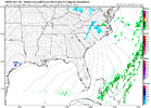
I missed this watching snow yesterday! Upstate had impressive storms I see!? Is Shetley ok??Someone is going to put up a big rain total tonight between KFAY and CAE


12Z HRRR seems to be doing about the same, just drier as usual with the HRRR runs where it fluctuates on amounts. Regardless, still some decent squallsthe 6z long range HRRR brings the vortmax way to the west and then sends it barreling east. It gives the ATL metro snow showers/snow squalls.
Though the 6z NAM continues what seems to be a trend of bringing the vortmax back up to the NE, which may be the death knell for anything breaking containment if it continues.
Was he from South Carolina ? Think
About time for a trip to Dixie Stampede!