• Hello, please take a minute to check out our awesome content, contributed by the wonderful members of our community. We hope you'll add your own thoughts and opinions by making a free account!

Wintry More SE Snow ? (1/16-1/18)

WWA issued only down to Carroll county by FFC... yet special wx statement says Lagrange north... models have certainly supported a further south toward Lagrange impact... BMX has great graphics that seem to be more in line with what models are currrently showing.. so is FFC just getting a starting point??? Or being conservative? Being on a state line is sometimes hard when one office is very conservative.... hmmm...

I’m guessing they want to play it safe & watch radar trends late tonight & tomorrow.
 
:rolleyes:

26730900_10157156670937178_8768385199064848847_n.png
Brick it looks like WRAL is becoming more certain we will get some snow showers out of this. My excitement is on board now, especially if the NAM runs tonight look more favorable. Wonder why they put such a low ceiling for potential for the southern Triangle? I mean, this isn't what they are predicting, this is their max potential. I'd have to say the potential should be greater than that, even if you are forecasting minute amounts.
 
15z SREF for HSV, mean trending up for the past 24 hours, though max is down.
 

Attachments

  • Screenshot_20180115-134107.png
    Screenshot_20180115-134107.png
    749.8 KB · Views: 41
Brick it looks like WRAL is becoming more certain we will get some snow showers out of this. My excitement is on board now, especially if the NAM runs tonight look more favorable. Wonder why they put such a low ceiling for potential for the southern Triangle? I mean, this isn't what they are predicting, this is their max potential. I'd have to say the potential should be greater than that, even if you are forecasting minute amounts.
I just think it is funny that it looks nothing like what any of the models are showing now.
 
Models keep upticking, I'd suspect some WSW issued between CLT area and RAH
 
Now things really look mismatched... BMX issues WWA all the way down to Montgomery
 
Does it matter if you get 2" over 1hr or 5 hours?
Me personally I’d rather have at 5 hours if I’m going to end up with the same amount.
Sun will melt snow even with temps below freezing.

This is very true as I didn’t get above 25 the last two days but still lost about 2 inches of the 4 or so I got.
 
Kbmx just extended their WWA to Troy, al,:)
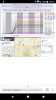
Winter Weather Advisory
URGENT - WINTER WEATHER MESSAGE
National Weather Service Birmingham AL
145 PM CST Mon Jan 15 2018

...SNOW MAY BRING SIGNIFICANT IMPACTS TO MUCH OF CENTRAL ALABAMA
TUESDAY MORNING THROUGH EARLY WEDNESDAY MORNING...

.An Arctic cold front will enter Northwest Alabama Tuesday
morning and move southeastward across Central Alabama Tuesday
afternoon into Tuesday night. This front should have enough
moisture and lift to generate a band of light to moderate snow,
which could potentially affect all of our forecast area. We will
need to watch and see if a second band can develop across the
southern third of the area during the evening and provide a higher
total down there as well. Though snowfall amounts are expected to
remain less than 2 inches, impacts to travel could be significant
due to temperatures falling into the 20s as the snow occurs.

ALZ011>015-017>036-160345-
/O.UPG.KBMX.WS.A.0001.180116T1200Z-180117T0900Z/
/O.NEW.KBMX.WW.Y.0002.180116T1200Z-180117T1200Z/
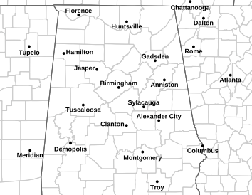
Marion-Lamar-Fayette-Winston-Walker-Blount-Etowah-Calhoun-
Cherokee-Cleburne-Pickens-Tuscaloosa-Jefferson-Shelby-St. Clair-
Talladega-Clay-Randolph-Sumter-Greene-Hale-Perry-Bibb-Chilton-
Coosa-
Including the cities of Hamilton, Sulligent, Vernon, Fayette,
Double Springs, Jasper, Oneonta, Gadsden, Anniston, Centre,
Heflin, Carrollton, Tuscaloosa, Birmingham, Hoover, Columbiana,
Pelham, Alabaster, Pell City, Moody, Talladega, Sylacauga,
Ashland, Roanoke, Livingston, Eutaw, Greensboro, Moundville,
Marion, Centreville, Clanton, and Rockford
145 PM CST Mon Jan 15 2018

...WINTER WEATHER ADVISORY IN EFFECT FROM 6 AM TUESDAY TO 6 AM
CST WEDNESDAY...

* WHAT...Snow expected. Plan on slippery road conditions,
especially during the evening commute on Tuesday. Total snow
accumulations of up to one inch are expected, with locally
higher totals of up to two inches.

* WHERE...Portions of northern and western Central Alabama.

* WHEN...From 6 AM Tuesday to 6 AM CST Wednesday.

* ADDITIONAL DETAILS...Be prepared for reduced visibilities at
times.

PRECAUTIONARY/PREPAREDNESS ACTIONS...

A Winter Weather Advisory for snow, means periods of snow will
cause primarily travel difficulties. Be prepared for snow covered
roads and limited visibilities, and use extreme caution while
driving.
 
I had hope the Euro would get back to what it was showing earlier, but it looks like it just won't get there. Alas, the biggest winner if this was going to work out was North Carolina anyway due to the redevelopment but a lot of Georgia will see some light snow. How much, who knows.
 
he latest(15z) SREF(short range ensemble forecast) model shows a mean(average) of snowfall for the following locations, and it is rising:
Muscle Shoals 1.55 inches
Ft. Payne 1.4 inches
Huntsville 1.2 inches
Gadsden 1.08 inches
Cullman 1.06 inches
Anniston 1.04 inches
Birmingham .84 of an inch
Tuscaloosa .72 of an inch
Auburn .59 of an inch
Montgomery .54 of an inch
Dothan .11 of an inch
 
That's great
he latest(15z) SREF(short range ensemble forecast) model shows a mean(average) of snowfall for the following locations, and it is rising:
Muscle Shoals 1.55 inches
Ft. Payne 1.4 inches
Huntsville 1.2 inches
Gadsden 1.08 inches
Cullman 1.06 inches
Anniston 1.04 inches
Birmingham .84 of an inch
Tuscaloosa .72 of an inch
Auburn .59 of an inch
Montgomery .54 of an inch
Dothan .11 of an inch
 
Back
Top