Good luck y'all. Ended with about 3/4" maybe an inch in spots
-
Hello, please take a minute to check out our awesome content, contributed by the wonderful members of our community. We hope you'll add your own thoughts and opinions by making a free account!
You are using an out of date browser. It may not display this or other websites correctly.
You should upgrade or use an alternative browser.
You should upgrade or use an alternative browser.
Wintry More SE Snow ? (1/16-1/18)
- Thread starter GeorgiaGirl
- Start date
Fixing to pass 3 inch mark. Temp is down to 26. Moderate snow,small flakes. Ratios really kicking upward. Feeling over confident we go over 6 mark and then some today.
Yes! I can confirm 3 here in Winston Salem. Moderate small flakes. You're in Randolph County right?
packfan98
Moderator
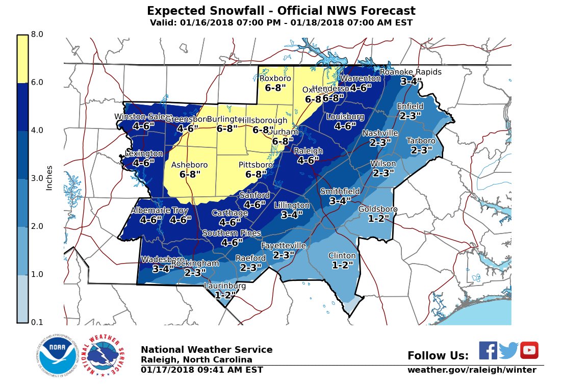
NWS Raleigh put out a new AFD and are bumping up totals from 5-6 to 5-8! BOOM!
Grilling one of emSnow and calves being born! What could be better!
Kylo
Member
Webberweather53
Meteorologist
B
Brick Tamland
Guest
Area Forecast Discussion
National Weather Service Raleigh NC
923 AM EST Wed Jan 17 2018
.SYNOPSIS...
A strong upper level disturbance and associated arctic cold front
will move through our region today. This will be followed bitter
cold arctic high pressure tonight into Friday morning. A warm-up
will begin Friday and extend into the weekend.
&&
.NEAR TERM /TODAY AND TONIGHT/...
As of 923 AM Wednesday...
...Winter Storm Warning for most of Central NC through 900 PM
tonight...
...Winter Weather Advisory for the SE Coastal Plain (Wayne and
Sampson through 900 PM...
Review of some of the latest 06z to 12z model guidance is coming
into collaboration(always a good thing as it increases confidence)
with what we are seeing in satellite data of cooling cloud tops east
of the mountains; a deeper more wrapped up mid/upper level system
along with additional supportive evidence in observational/boots on
the ground data of 2 inches already on the ground in the Triad and
impressive-slowing moving snow band over the Piedmont, in an axis
just east of the Triad and just west of the Triangle, extending from
Troy to Siler City to Hillsborough to Roxboro/Oxford, that will
likely produce snowfall rates locally up to 1 inch per hour.
And let`s not overlook the deep moist cold snow sounding at GSO. All
of which will supportive of wetter-snowier/slower/more robust
system, with great set-up for CSI mesoscale banding across central
NC Piedmont as suggestive by the 06z later this morning between 15
to 21z. This band will move slowly east throughout the remainder of
the morning and afternoon hours, eventually shifting east and out of
the area by the early evening. Given all the supporting evidence,
will be increasing the snow amounts from 5 to 6 inch to 5 to 8
inches across much of the NC Piedmont, tapering off to 2 to 4 inches
across the central and northern Coastal Plain counties, to 1 to 2
across the far SE counties.
Although slower than previous forecasts, due to the deeper more
wrapped system, once precip develops, temps will cool into the 20s.
Scooter
Member
Approaching 3" in Wallburg also. When it starts to pivot should the rates pick up here in the triad before moving toward Raleigh?
Snownut
Member
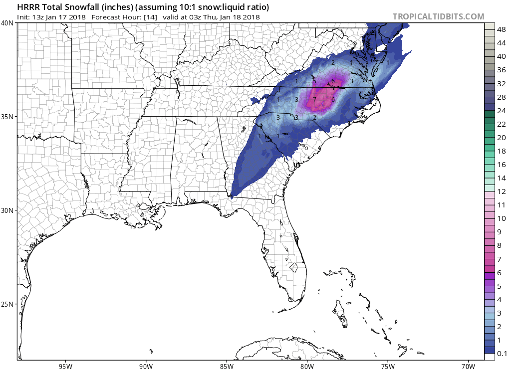
What's causing that redevelopment over the upstate?Latest HRRR says the precip really cranks from 10am through 7pm tonight for Wake County. Tough to watch the radar after what happened two weeks ago, maybe this doesn't pivot much further east.View attachment 3252
Sent from my SM-G955U using Tapatalk
Webberweather53
Meteorologist
With SLRs > 10:1 here we could see 9-10" easy according to HRRR
Still nothing in SE Wake. Man this sucks!
Holy crap. I just saw that.HRRR just showed .81 qpf over your house dude..... wow!
Sent from my SM-G955U using Tapatalk
I'm getting some drizzleStill nothing in SE Wake. Man this sucks!
Sent from my SM-G955U using Tapatalk
BPATL
Member
Kylo
Member
What's causing that redevelopment over the upstate?
Sent from my SM-G955U using Tapatalk
Low pressure. Check out -------------'s latest video, it covers it well.
dpbutler1
Member
I just hit the 2.5 inch at my house.Around two inches of snow imby, I think I'm well on my way to 4-6" imo.
packfan98
Moderator
Brad P just put out a video and is up to 2-4 for the Charlotte metro with some 5 or 6 inch maximums.
Kylo
Member
Just started lightly snowing, maybe a mix of rain.
Hemidawg
Member
CentralGAColdFront
Member
I've got a good dusting on the ground and this easily is the most snow that I've received since February 12, 2010.
We have a pivot! Precip has a north to south orientation! She's stalling out! Upstate up through Charlotte about to pile it on
Webberweather53
Meteorologist
campamy
Member
We ended up with 1" on this side of Cleveland. I usually do better than in downtown Cleveland and definitely better than Chattanooga. Maybe it's being so much closer to the mountains?Lol southeast TN got a dusting
FlurriesI'm getting some drizzle
Sent from my SM-G955U using Tapatalk
Sent from my SM-G920V using Tapatalk
Showmeyourtds
Member
Nice view of the AU campus this morning. Models showed a jackpot zone in this area last night

Sent from my iPad using Tapatalk

Sent from my iPad using Tapatalk
I can still see partly cloudy skies to my East and yet as soon as the first radar returns came over head I've got flurries pretty impressive actuallyFlurries
Sent from my SM-G920V using Tapatalk
Sent from my SM-G920V using Tapatalk
packfan98
Moderator
Must be close to 3" here. Just about every blade of grass covered. My favorite type of storm. All day snow! No mixing! Absolutely beautiful!
B
Brick Tamland
Guest
Not really sticking here yet. Wonder how long that will take?
BPATL
Member
For you Walking Dead fans, here is a snowy Alexandria.
Love it, are they still filming down there???
packfan98
Moderator
Their new expected snowfall map is now more than their last worst case scenario map!


kofiagyeiafc
Member
We still have some flurries here in Hampton.
BPATL
Member
Forgot about hitting 30 today in Atlanta!
We in no way are coming close to 30 today I am still steady at 12, maybe 22-26...
I love the HRRR holding the heavy returns around the area from roughly 15-22z and flurries until around 4-5z. Looking at the composite reflectivity that is one hell of a band setting up along the US1 corridor
In Carrollton, GA ... approximately 1 inch. Temp was reading 9. Rooting for folks to the east now. GaWx, maybe you can get into the action as well, but I see that is not expected for you or Pcbjr, I guess not a true board-wide event since you did not get anything, but I don't think we could be closer than this time. Good luck to all and congratulations to all who scored!
marino13882
Member
Really picking up here in Apex over the last few minutes.
Snowflowxxl
Member
Just walked around, and wow the roads are HORRIBLE in Atlanta. Solid sheet
WCDawson
Member
The snow hole was real! It was over Dahlonega, GA. A bare dusting in places and nothing at all in others. Pretty incredible!


