-
Hello, please take a minute to check out our awesome content, contributed by the wonderful members of our community. We hope you'll add your own thoughts and opinions by making a free account!
You are using an out of date browser. It may not display this or other websites correctly.
You should upgrade or use an alternative browser.
You should upgrade or use an alternative browser.
Pattern Microwave March
- Thread starter SD
- Start date
ATLwxfan
Member
Have there been warm solar min winters in the past 25 years?
Sent from my iPhone using Tapatalk
Sent from my iPhone using Tapatalk
I'm pretty disappointed in how the first week of March is most likely going to play it. A little bit of western ridging and we would be in the game for a late season storm.
Sent from my SM-G928V using Tapatalk
Sent from my SM-G928V using Tapatalk
Have there been warm solar min winters in the past 25 years?
Sent from my iPhone using Tapatalk
At ATL, 1996-7 was a solid 4 warmer than normal.
Webberweather53
Meteorologist
Webb - Unfortunately I can only "Like" this once - but here's 4X - great observation/post!
Phil
Haha thanks, still a lot of "ifs" at this point in time, would like to at least get well beyond the spring persistence barrier to see how QBO & ENSO evolve going into the late spring/summer
pcbjr
Member
Haha thanks, still a lot of "ifs" at this point in time, would like to at least get well beyond the spring persistence barrier to see how QBO & ENSO evolve going into the late spring/summer
I'm checking out the weeklies, it still has a storm signal coming up from the GOM during the 11th-12th time frame (timing will change). It has it being suppressed, (colder air indication). Will be interesting once the OP and ensembles get into that range.
ForsythSnow
Moderator
I have given up on getting any more snow this winter, but if we can stay cool after this extremely warm winter, then bring it. But first, let's see if places can break 80 for a few days in March lol.I'm pretty disappointed in how the first week of March is most likely going to play it. A little bit of western ridging and we would be in the game for a late season storm.
Sent from my SM-G928V using Tapatalk
Euro weeklies are meh. The control is better decent. Looking at the meteogram pretty good signal for some near to below normal weather between the 6th and 16th mean is actually .8 of snow here and near 6 inches of rain
Sent from my SM-G928V using Tapatalk
Sent from my SM-G928V using Tapatalk
Pretty sure JB is going with pattern flip and cold March, still!Euro weeklies are meh. The control is better decent. Looking at the meteogram pretty good signal for some near to below normal weather between the 6th and 16th mean is actually .8 of snow here and near 6 inches of rain
Sent from my SM-G928V using Tapatalk
I don't think that's impossible outside of the SE and somewhat likely for a good part of the northern tier. I'm doubtful we will could erase the anomalies from March 1-6 even if we did go coldPretty sure JB is going with pattern flip and cold March, still!

I wouldn't be shocked if these were too low
Sent from my SM-G928V using Tapatalk
Last edited:
ATLwxfan
Member
GB doing his thing.

Sent from my iPhone using Tapatalk

Sent from my iPhone using Tapatalk
Stormlover
Member
wow, Robert at wxsouth says freezes may be over for miss, ala, Geor, sc...I doubt that
It could be that some areas in MS, AL, GA, SC have already had their last Freeze.
It could be that some areas in MS, AL, GA, SC have already had their last Freeze.
This month marks 13 straight months of above normal temps in ATL. Is it ever going to end ? Anyone see any end in sight ? Maybe we will go like 5 years straight of above normal ? Larry, has ATL ever had 13 straight months of AN temps before in recorded history ?
accu35
Member
I'll be iowa on the 27,28,1st on trip. I'm sure I'll see snow there, it's none stop cutters headed that direction
This month marks 13 straight months of above normal temps in ATL. Is it ever going to end ? Anyone see any end in sight ? Maybe we will go like 5 years straight of above normal ? Larry, has ATL ever had 13 straight months of AN temps before in recorded history ?
No. The old record of 12 months in a row was from May of 1881 through April of 1882. Congrats to ATL!
Jon
Member
wow, Robert at wxsouth says freezes may be over for miss, ala, Geor, sc...I doubt that
It could be that some areas in MS, AL, GA, SC have already had their last Freeze.
Leave SC out and that statement could verify with gulf counties in MS/AL/GA. Carefully worded by him....
As for NC, I heard Greg Fishel say the top 10 warmest Febs were all followed by freezes in March, so it's basically guaranteed.
Winter is largely over as I don't think we win out against the SE ridge, but a freeze is definitely not out of the question with a cold shot after March 8th
Sent from my iPhone using Tapatalk
Call me crazy but I find it hard to bet against another freeze or 2 in MarchLeave SC out and that statement could verify with gulf counties in MS/AL/GA. Carefully worded by him....
As for NC, I heard Greg Fishel say the top 10 warmest Febs were all followed by freezes in March, so it's basically guaranteed.
Winter is largely over as I don't think we win out against the SE ridge, but a freeze is definitely not out of the question with a cold shot after March 8th
Sent from my iPhone using Tapatalk
I don't disagree, but what a disaster this winter has been. It wouldn't surprise me if we didn't freeze again. It really wouldn't.Call me crazy but I find it hard to bet against another freeze or 2 in March
ATLwxfan
Member
I don't disagree, but what a disaster this winter has been. It wouldn't surprise me if we didn't freeze again. It really wouldn't.
I'd bet against a freeze. We'll see some 30's but I'm with Robert. I think the SER sticks around through summer. I'm just basing that on persistence.
Sent from my iPhone using Tapatalk
pcbjr
Member
The way this "winter" has gone, it's not safe to bet against anything ... 
I tend to think that the SER will get shunted out a time or two. Although it's seemingly hung around most of the winter, we've seen it pack its bags a couple of times. There's a lot of cold building up in central/eastern Canada. We'll see if the stars align one more time, but like I said, I wouldn't be surprised if we just stayed above normal for the rest of the winter. Then, we'll get into April/May and see blocking get established and have below normal with light rain.I'd bet against a freeze. We'll see some 30's but I'm with Robert. I think the SER sticks around through summer. I'm just basing that on persistence.
Sent from my iPhone using Tapatalk
Well we have 7 more days of winter so you're not really going out on a limb there.I tend to think that the SER will get shunted out a time or two. Although it's seemingly hung around most of the winter, we've seen it pack its bags a couple of times. There's a lot of cold building up in central/eastern Canada. We'll see if the stars align one more time, but like I said, I wouldn't be surprised if we just stayed above normal for the rest of the winter. Then, we'll get into April/May and see blocking get established and have below normal with light rain.
Last edited:
ForsythSnow
Moderator
Toss this look, it's in fantasy land LOL. One could only wish though.


Allow me to clarify: Even though I said "winter", I meant through the remainder of the time where freezing is generally possible: now-April. That's a pretty wide window, and we have seen freezes through this period historically.Ive had more snow
Well we have 7 more days of winter so you're not really going out on a limb there.
pcbjr
Member
12Z GFS is at least trying to show something cool/cold towards the end of the run ... beyond truncation but more than we've seen in daysAllow me to clarify: Even though I said "winter", I meant through the remainder of the time where freezing is generally possible: now-April. That's a pretty wide window, and we have seen freezes through this period historically.
pcbjr
Member
at least the 12z ensemble is not torching us into eternity ...
http://mp1.met.psu.edu/~fxg1/ENSTDEP2WIDE_12z/tloop.html
http://mp1.met.psu.edu/~fxg1/ENSTDEP2WIDE_12z/tloop.html
WEATHERBOYROY
Member
Looking at the forecast change in Canada, I would think BELOW FREEZING temps all the way to Bham are gonna happen.Call me crazy but I find it hard to bet against another freeze or 2 in March
Yeah there will be another freeze, no doubt about it.
Webberweather53
Meteorologist
It's definitely way too early to say there won't be at least another freeze or two across the Carolinas. The average last freeze doesn't usually occur until late March-early April, and even in a background skewed towards above-well above normal temperatures, we still have at least another month or so left before we can get comfortable...

JHS
Member
The big news will probably be the resurgence of the drought unless things change. I look for D4 drought to cover most of the southeast by May 1. This summer will probably be hotter than 2007 and longer lasting too. Someone may get close to 120 in SC or GA.
Webberweather53
Meteorologist
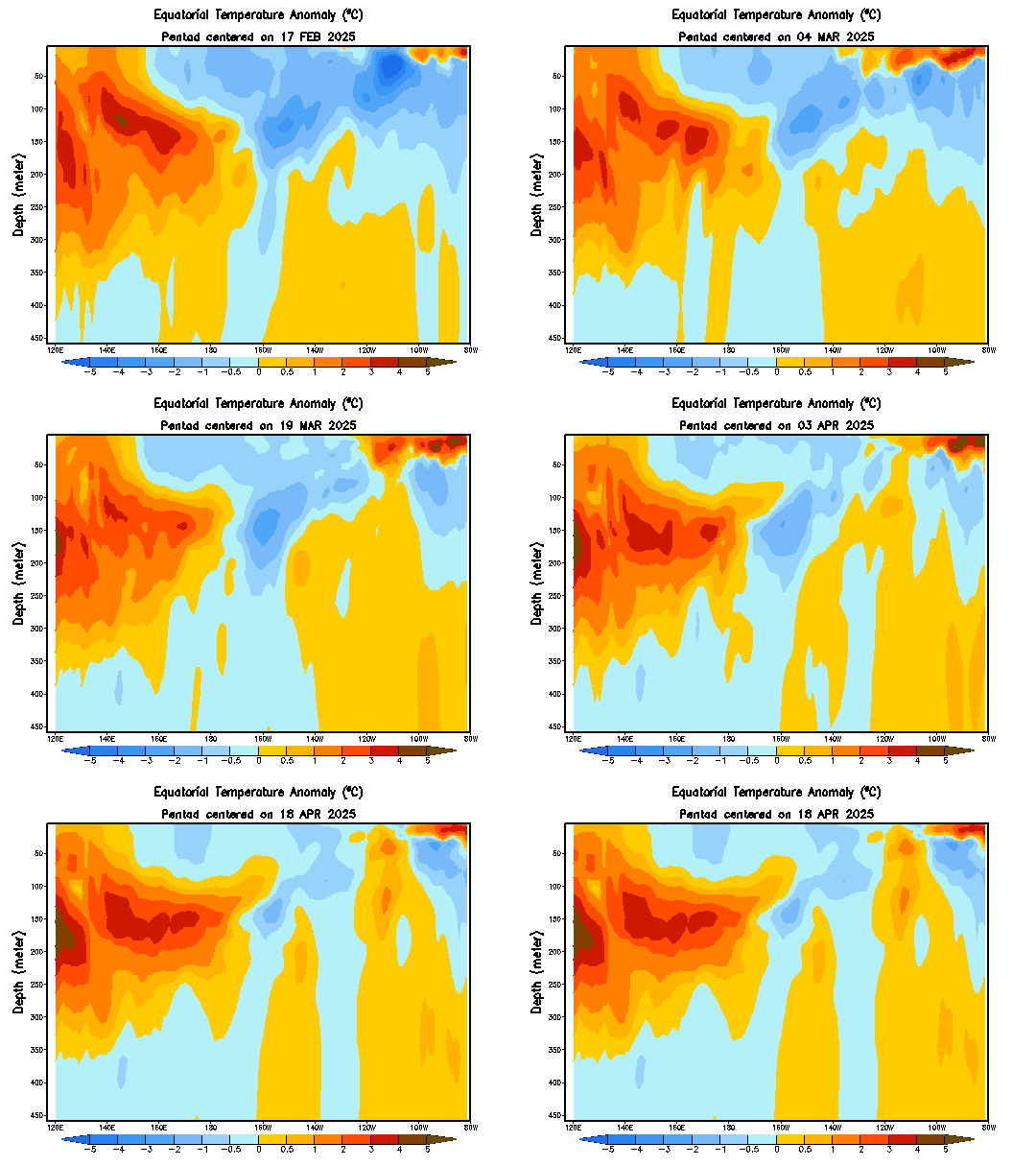
Definitely worth keeping an eye on this animation over the next several weeks to see if a downwelling oceanic kelvin wave was generated by the MJO pulse that's currently over the western hemisphere. The thermocline has started to become anomalously suppressed near and just west of the International Dateline within the last week or so...


ForsythSnow
Moderator
I don't really think that we will see the drought get worse, and I believe it will get better, but it will occur slowly. There may be periods of the drought growing, but I think that it will overall by May be a lot smaller than right now. If it does get worse, D4 won't cover that large of an area. As far as 120? Doubt it. I would bet more on having snow before April than someone reaching 120.The big news will probably be the resurgence of the drought unless things change. I look for D4 drought to cover most of the southeast by May 1. This summer will probably be hotter than 2007 and longer lasting too. Someone may get close to 120 in SC or GA.
Last edited:
olhausen
Member
The big news will probably be the resurgence of the drought unless things change. I look for D4 drought to cover most of the southeast by May 1. This summer will probably be hotter than 2007 and longer lasting too. Someone may get close to 120 in SC or GA.
120 with more drought to come? Sounds more like Death Valley then the southeast that you are describing if you ask me.
pcbjr
Member
CPC isn't biting on a freeze any time soon - which given history, might be somewhat of a good sign for one


Average last freeze in North GA is about the same as in most of NCIt's definitely way too early to say there won't be at least another freeze or two across the Carolinas. The average last freeze doesn't usually occur until late March-early April, and even in a background skewed towards above-well above normal temperatures, we still have at least another month or so left before we can get comfortable...
View attachment 207
pcbjr
Member
and at least AL and west GA may not get too dry the next couple of weeks; NC/SC don't look so good (nor do I)...


Webberweather53
Meteorologist
Week 3-4 CPC temperature/precipitation outlook and discussion. Should see more seasonable temps return to the southeastern US as we get into the 2nd week of March, with above-well above normal precipitation, but we're liable to go back into the fryer before long as hinted at by the very stable retrogression of the mid-latitude rossby wave train w/ North Pacific ridging quickly retrograding and decaying over the WPO domain... The CPC forecast is similar to what the European Weeklies are depicting through mid March.
"Prognostic Discussion for Experimental Week 3-4 Outlook
NWS Climate Prediction Center College Park MD
300PM EST Fri Feb 17 2017
Week 3-4 Forecast Discussion Valid Sat Mar 04 2017-Fri Mar 17 2017
ENSO-neutral conditions currently are present across the equatorial Pacific Ocean. Equatorial sea surface temperatures (SSTs) are near average in the central and east-central Pacific Ocean, while above average SSTs are in the eastern Pacific Ocean. The RMM-based MJO index indicated a robust eastward propagation of a MJO signal across the Western Pacific into the Western Hemisphere during the last couple of days. During the next two weeks, the GEFS depicts continued eastward propagation with reduction in amplitude over the western Hemisphere. The MJO is anticipated to influence the evolution of the global tropical convective pattern during the next several weeks. In addition to this anticipated evolution of the global tropical convective pattern, dynamical model guidance from the CFS, ECMWF, and JMA, statistical tools, long term trends, and consistent evolution from the Week-2 forecast were considered for this Week 3-4 outlook.
Dynamical model guidance for the Week 3-4 period is generally in good agreement among the CFS, ECMWF, and JMA solutions, depicting a trough over the eastern CONUS, with a ridge over the western CONUS and Alaska. The forecast height anomaly patterns exhibit some differences among the tools, however. The CFS and ECMWF ensemble mean forecasts depict below-normal 500-hPa heights over parts of the Northern Plains, the Upper Mississippi Valley, the Great Lakes, and the Northwest, while the JMA ensemble mean only shows below- normal 500-hpa heights over the Northeast. All dynamical models indicate positive 500-hPa height anomalies over Western CONUS, Alaska, and Florida. The ECMWF and JMA ensemble mean forecasts also predict positive 500-hPa height anomalies over Hawaii.
Above-normal 500-hPa heights and ridging lead to enhanced probabilities for near to above normal temperatures over Florida, most of the western CONUS, and Alaska, with the highest probabilities over California and western Alaska. This pattern is also supported by dynamical model temperature guidance tools (CFS, ECMWF and JMA). Below-normal 500-hPa heights and trough enhance probabilities for below-normal temperatures for parts of the Great Plains, and most of the northeastern CONUS.
There are enhanced probabilities for near- to above-median precipitation for most of the southeastern CONUS in association with a trough forecast near the eastern CONUS. Below-median precipitation is favored over California downstream of forecast anomalous ridging. Dynamical guidance (CFS and ECMWF) predicts below-median precipitation over the Great Lakes, and southwestern Alaska, with above-median precipitation over Montana.
Above-normal temperatures are forecast across Hawaii due to persistent anomalously warm sea surface temperatures and positive 500-hpa height anomalies across the region. Dynamical model guidance from the CFS, ECMWF, and JMA favors below-median precipitation for Kahului and Honolulu."


pcbjr
Member
Great catch, Webb! Fingers crossed. especially on the precip! We may need to store it up into late Spring.
Thanks!
Phil
Thanks!
Phil


