B
Brick Tamland
Guest
Tornado warning for Halifax County, VA. Storm is moving south.

Wonder if anything can make it this far south tonight. Storm has weakened a bitTornado warning for Halifax County, VA. Storm is moving south.
. Welcome to summer again lol. Also so much for that Pacific storm it is just fizzling out versus becoming a hurricane like they originally thought.Plz God no
Sent from my SM-G928V using Tapatalk

I saw that before I passed out for the night (a full dose of Nyquil does that to me) anywho I saw the alerts on my phone where at some point I was under a severe thunderstorm warning but it looked like it just missed to my west. I never heard a thingThe storm near Lynchburg has metwannabe special written all over it not to mention the potential morning MCS
Sent from my SM-G928V using Tapatalk
I like the potential for the early eveningWell, guess there is a chance of severe storms around here today, which usually means there won't be any storms at all around here.
Same for the tennesssee. Models struggle up to the 12 hour window it seems like. Most systems either under perform or over achieve SPC forecastJust watched Matthew East's daily video and he talked about the storm system for tomorrow being complex and difficult to forecast. Anyone else notice lately all the storm systems around here seem to be complex and difficult to forecast? I don't recall it being like this so often with spring and summer storm systems. It really is getting just as hard to forecast them as it is snow storms around here. Feels like the dynamics and parameters that mets use to forecast aren't as reliable and have changed.
Just watched Matthew East's daily video and he talked about the storm system for tomorrow being complex and difficult to forecast. Anyone else notice lately all the storm systems around here seem to be complex and difficult to forecast? I don't recall it being like this so often with spring and summer storm systems. It really is getting just as hard to forecast them as it is snow storms around here. Feels like the dynamics and parameters that mets use to forecast aren't as reliable and have changed.
Checks radar: oops! Looks like rain incoming today, in minutes! My local met said we would see absol no rain today!!!I'm going to make it to 90 on a mostly cloudy/cloudy day!? Congrats to me! And tomorrow's storm/rain chances seem to be diminishing! I'm on the JHS bandwagon!
I don't think we make it to 90 today because of these clouds. IF they clear out soon we could get close though. Most important to me though, is that these clouds are helping it stay cooler in the house. Bright sun on a tin roof isn't nice.I'm going to make it to 90 on a mostly cloudy/cloudy day!? Congrats to me! And tomorrow's storm/rain chances seem to be diminishing! I'm on the JHS bandwagon!
I'd love opinions on this. How could katl have had a high on 5/5/17 of 56 when the midnight reading for 5/5/17 was 57??
This shows a high of 56 on 5/5/17:
http://kamala.cod.edu/ga/latest.cdus42.ATL.KFFC.html
This shows 57 at 12AM on 5/5/17:
http://kamala.cod.edu/offs/KFFC/1705050403.asus42.FFC.html
Either way it is a record low high!
maybe they did the midnight at 11:59 ... LOL
Readings are taken about 10 minutes before the hour.
I wasn't joking, just making a point with some hopeful humor!pcbjr may have been joking but actually had the right idea. Also, BHS was dead-on correct:
From Kyle at FFC: "So here lies the problem. The temperature dropped from 57 to 55 degrees in this hour, and unfortunately, these measurements are not taken exactly on the hour, usually, they are taken a few minutes before. So the 57 F measurement you saw at midnight was actually taken just 8 minutes before midnight and the temperature dropped to 56 before the turn of the hour and then to 55 by 12:52 AM. Since the METARS do not transmit minute by minute data, we can't see the transition firsthand. However, the METARs do record the high and low temp for the full 24 hours of a day, and since the recorded high was 56, the temperature the must have dropped at this site before midnight."


And just up the road at JAXLovely day in the neighborhood ...
Dante's 7th Circle, the 3rd ring ... raining fire from the sky ...And just up the road at JAX
Visibilities may be locally reduced to around a mile at
times in this area...but otherwise will be reduced to 2 to 5 miles
with a strong smell of smoke in the air and occasional periods of
falling ash.
Since there's nothing else to forecast that will be falling from the sky....

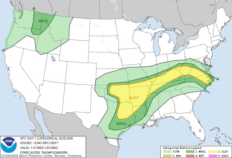
I feel like we're always in the slight just to cover the bases. It's always 50/50 here of bad storms or nothing at all.
Well light rain from earlier is gone and sun is out, atmosphere destabilization is commencing nicely....I feel like we're always in the slight just to cover the bases. It's always 50/50 here of bad storms or nothing at all.
SB cape is increasing nicely ML cape is meh.Well light rain from earlier is gone and sun is out, atmosphere destabilization is commencing nicely....


Storms are firing in Va dropping se, here we go... maybeOh I guess spc is too
Sent from my SM-G928V using Tapatalk
Good luck! For plain ol' rain, that is ...Storms are firing in Va dropping se, here we go... maybe
Sent from my SM-G920V using Tapatalk
Nice one headed your wayStorms are firing in Va dropping se, here we go... maybe
Sent from my SM-G920V using Tapatalk
Missing to my west again. I think you get in on the fun eventuallyNice one headed your way
Sent from my SM-G928V using Tapatalk