ForsythSnow
Moderator
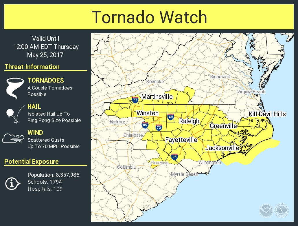
And outgoing here. This line is a flop here as it dissipated, but looks way worse to the East. Final total is somewhere between 3 and 5 inches. Time to dry out.Tornado watch incoming
And outgoing here. This line is a flop here as it dissipated, but looks way worse to the East. Final total is somewhere between 3 and 5 inches. Time to dry out.Tornado watch incoming
Tornado watch incoming

Wake Co. split incoming, according to the 18z HRRRRRRRRR^RTornado watch incoming
It would be funny if it didn't happen so often. I swear, any system that isn't sunny and dry is so hard to forecast around here now.Wake Co. split incoming, according to the 18z HRRRRRRRRR^R
Just like the winter stormsWake Co. split incoming, according to the 18z HRRRRRRRRR^R
Wake Co. split incoming, according to the 18z HRRRRRRRRR^R
It would be funny if it didn't happen so often. I swear, any system that isn't sunny and dry is so hard to forecast around here now.
Interested to see if any discrete cells can get going out ahead of the main band..Wouldn't surprise me but the parameters have come together nicely over the last few hours. Lapse rates are a little meh but other than that the atmosphere doesn't look bad at all
I would guess that this setup favors more of the grouped together multicells with the southern or southeastern storm having a potential to produce a tornadoInterested to see if any discrete cells can get going out ahead of the main band..
Like the one down there just SE of Lumberton that may be one that will need to be watched
Gotcha.... I see the cell I mentioned is no longer a discrete cell. So rain wrapped mess, nice. And that line coming in out SC is getting it's act together.I would guess that this setup favors more of the grouped together multicells with the southern or southeastern storm having a potential to produce a tornado
Yeah Im about to head home from the office a little early. I loathe the idea of being on I40 in a severe tstormGotcha.... I see the cell I mentioned is no longer a discrete cell. So rain wrapped mess, nice. And that line coming in out SC is getting it's act together.
With the way things are playing out right now the HRRR not that far off from the split it was showing earlier....Yeah Im about to head home from the office a little early. I loathe the idea of being on I40 in a severe tstorm
Of course!With the way things are playing out right now the HRRR not that far off from the split it was showing earlier....
Y'all have a tornado warned cell due south if it holds look out.....HRRR looks pitiful for Wake. 18Z NAM looks a lot better.
Yeah it's been fairly active in western part of NC this afternoon no doubtTornado warning for Yadkin and Forsyth Counties NC until 4:45 PM. Areas affected are Lewisville, Stanleyville, Courtney, Yadkinville, Rural Hall. Funnel cloud reported on the ground NE of Mockcville NC moving NE at 4:10PM
This one.....HRRR looks pitiful for Wake. 18Z NAM looks a lot better.
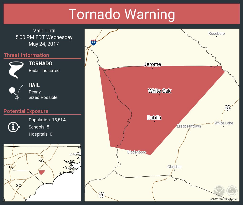
That whole line is severe warned. It's one county away from me right now. Should hit the SE Wake dispersion zone here momentarily.Y'all have a tornado warned cell due south if it holds look out.....