Radiant and Webb have repeatedly emphasized that a good portion of the ensemble model consensus as well as Euro op cold bias has been due to much too low nighttime temps over snowcover. That is a big problem.
-
Hello, please take a minute to check out our awesome content, contributed by the wonderful members of our community. We hope you'll add your own thoughts and opinions by making a free account!
You are using an out of date browser. It may not display this or other websites correctly.
You should upgrade or use an alternative browser.
You should upgrade or use an alternative browser.
Haven’t seen a cold bias on the euro ever really? Only on Gfs twins ... anyone see what the endembles for the euro showed? Looking to see if there’s more support for this coastal
Haven’t seen a cold bias on the euro ever really? Only on Gfs twins ... anyone see what the endembles for the euro showed? Looking to see if there’s more support for this coastal
The Euro, like the GEFS, absolutely has a significant cold bias of 2 meter temps over snowcover. I just got confirmation from Radiant that the Euro suite is actually worse than the GEFS though the GEFS does have snowcover cold bias. I think @Webberweather53 has also noted this. The CMC suite also has the same problem. The operational GFS otoh has a good bit less snowcover cold bias on average.
The good news is that as we come out of winter, the impact of snowcover cold bias will diminish due to less snowcover.
Great post. You can bet your sweet ass when the spring melt ensues and those 80’s start showing up at hour 300 they’re going to verifyThe Euro, like the GEFS, absolutely has a significant cold bias of 2 meter temps over snowcover. I just got confirmation from Radiant that the Euro suite is actually worse than the GEFS though the GEFS does have snowcover cold bias. I think @Webberweather53 has also noted this. The CMC suite also has the same problem. The operational GFS otoh has a good bit less snowcover cold bias on average.
The good news is that as we come out of winter, the impact of snowcover cold bias will diminish due to less snowcover.
snowlover91
Member
The Euro, like the GEFS, absolutely has a significant cold bias of 2 meter temps over snowcover. I just got confirmation from Radiant that the Euro suite is actually worse than the GEFS though the GEFS does have snowcover cold bias. I think @Webberweather53 has also noted this. The CMC suite also has the same problem. The operational GFS otoh has a good bit less snowcover cold bias on average.
The good news is that as we come out of winter, the impact of snowcover cold bias will diminish due to less snowcover.
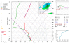
I took a look at various temp anomalies/profiles and while there is a consistent cold bias the Euro is actually better throughout all layers of the atmosphere. Per this chart the GFS is significantly more cold biased in the 5+ range than the Euro. Here is the link if you want to do some digging. It's also no surprise that the 5 and 10 day Fv3 is horrible, worse than even the CFS model with a horrendous cold bias.

Here's another chart for the 1000hPA level. Again the Euro at 5 and 10 days is consistently better than the GFS. I'm curious where Radiant gets their info from since this data indicates the GFS is significantly worse than the Euro at all levels of the atmosphere, especially day 5+.


Last edited:
snowlover91
Member
In fact you can see clearly in this chart not only the overall cold bias of models but also how BAD the Fv3 has been performing. Interestingly the Euro and FNO (NAVGEM??) are the two models which exhibit the least bias at the 1,000hPa level.

For the 850 level the Euro, UK and FNO are the best models. No surprise that the CFS and Fv3 are considerably worse.

For the 850 level the Euro, UK and FNO are the best models. No surprise that the CFS and Fv3 are considerably worse.
@snowlover91 , thanks for your replies. I know from my own obs that the op Euro has a bad fresh snowcover related cold bias. I didn't need Radiant to tell me that. I've seen it repeatedly in modeled snowstorms, where it would sometimes show something like a 20 degree drop vs surrounding areas, mainly at night. The degree of temperature drop is ridiculous and that has been mentioned here by others like @Webberweather53. The bias is at 2 meters rather than at other layers. So, even the 1,000 mb layer may be largely irrelevant.
Another thing is that the charts you're showing are based on overall bias whereas I'm addressing only snowcover related cold bias. That may be a reason for any discrepancy. Also, I think Radiant was saying that the bias is most evident in the days 1-5 period.
Another thing is that the charts you're showing are based on overall bias whereas I'm addressing only snowcover related cold bias. That may be a reason for any discrepancy. Also, I think Radiant was saying that the bias is most evident in the days 1-5 period.
Last edited:
Euro is about to show something interesting I bet with a formidable low in the Gulf day 6
snowlover91
Member
@snowlover91 , thanks for your replies. I know from my own obs that the op Euro has a bad fresh snowcover related cold bias. I didn't need Radiant to tell me that. I've seen it repeatedly in modeled snowstorms, where it would sometimes show something like a 20 degree drop vs surrounding areas, mainly at night. The degree of temperature drop is ridiculous and that has been mentioned here by others like @Webberweather53. The bias is at 2 meters rather than at other layers. So, even the 1,000 mb layer may be largely irrelevant.
Another thing is that the charts you're showing are based on overall bias whereas I'm addressing only snowcover related cold bias. That may be a reason for any discrepancy. Also, I think Radiant was saying that the bias is most evident in the days 1-5 period.
I did a bit of research and found an article written in October 2018 addressing some of the common ECMWF biases and the research being done to mitigate it. They did actually uncover a bias with the snow cover but it was a bit different in the region they analyzed. The results they came up with for the region they studied actually indicated the Euro had a warm bias. Here is the graph and explanation for what they found.

"Another factor appears to be the representation of snow cover in the IFS. In clear, calm nights in the real atmosphere, the uppermost layers of the snow cool rapidly, and a strong vertical temperature gradient is established within the snowpack. The skin temperature of the snow drops substantially and T2m decreases accordingly. The single-layer snowpack used operationally in the IFS at present reacts more slowly, due to its larger thermal inertia. The result is a delay in the drop in skin temperature. This delay cannot be fully compensated for by reducing the coupling between the skin temperature and the snow layer because that would lead to an overestimation of the daytime warming of the snow surface. Preliminary results from tests performed with an experimental multi-layer snow scheme show substantial improvement in the form of 2–3 K stronger night-time T2m drops when conditions are undisturbed (Figure 6). However, some adverse effects on daytime T2m (increase of the warm bias) have been noted which require further study." Link
I also found this in the user guide here which explains some of the biases with the model in regards to snow cover. They mention situations in which the bias can be affected both on the high and low side. Interesting.
Effects of Snow Cover
In both ENS and HRES small amounts of snow on the ground tend to take too long to melt, even if the temperature of the overlying air is well above zero.
In marginal snow situations, when precipitation at the surface comprises both rain and snow, the snow component accumulates as lying snow whereas it would usually melt instantly. This can lead to the proliferation of areas where a there is an incorrect small amount of snow cover. There is some evidence that such problems became a little worse when IFS cycle 43R3 was introduced in July 2017.
At a given location, at a given time, all the snow on the ground is assumed to have the same density. This density varies according to:
- its age (the model facilitates slow, natural compression),
- melting,
- interception (of rain)
- addition of new snow.
The effect of lakes is parameterised using FLake and a lake cover mask. The sub-grid detail may not be completely captured and, particularly where frozen lakes are plentiful and/or forecast snow cover uncertain, the energy fluxes may well be incorrectly estimated. These aspects can:
- amplify errors in forecast 2m temperatures, and
- introduce biases...
- snow cover in anticyclonic conditions with light winds,
- clear skies and strengthening night time surface inversion.
Conversely spurious snow cover, that should have melted, can lead to temperatures being as much as 5 or 10C too low, particularly if the model retains a depth of >10cm, the level at which the ground is assumed to be completely covered.
Users need to be aware of this complex array of 2m temperature forecast issues related to snow cover, and also of potential impacts on other forecast parameters.
Summary of 2m temperature errors:
- wintertime - large errors of both signs are possible, but overall temperatures tend to be too cold overnight, especially over rugged or mountainous areas. Possible contributory factors are errors in:
- coupling with ground heat flux,
- lake temperatures, particularly in deciding whether the lake is frozen or not,
- decreased boundary layer mixing in light or calm winds, particularly in stable conditions or inversions,
- the extent, thickness or existence of low-level clouds or mis-forecast clear skies,
- snow cover - note there is only one layer in the snow scheme and the heat flux may be deficient.
Last edited:
Nothing to complain about with the look on day 7 euro .. consistency is great especially with the euro let’s see if it goes boom
Webberweather53
Meteorologist
Finally! A classic NINO pattern! Oh wait that's right.. we waited until it was virtually spring to see it.
Womp.
Cold rain incoming
.png")
Womp.
Cold rain incoming
snowlover91
Member
I also came across this chart based on temp bias from the Euro model in Europe.

Routine verification against SYNOP weather station observations shows that T2m biases in the IFS have diurnal and annual cycles (Figure 1) and a pronounced regional dependence. In winter, for example, there is a night-time cold bias of 0.5–1 K in large parts of Europe, and a warm bias of several K throughout the day in parts of Scandinavia (Figure 2). In summer, there is a general underestimation of the amplitude of the diurnal cycle of temperature and a daytime low-humidity bias. Over recent years, there have been some changes in these biases due to model changes, but they are relatively robust in terms of geographical patterns and annual and diurnal variations.
More can be read here in the full article. It would seem that the bias across Europe at night has been improving while the day bias has been largely about the same.
pcbjr
Member
Bye bye pollen and hello oak "worm" paste ...The 12Z Euro late run has all rain and it is mostly in FL, some in S GA, and a tiny bit along the Carolinas coasts.
NBAcentel
Member
Tbh Any sort of winter precip in my opinion is over for tha SE (except maybe for the mountains), I’m just hoping for a calm hurricane season at this point, I think we deserve a break
The 12Z Euro late run has all rain and it is mostly in FL, some in S GA, and a tiny bit along the Carolinas coasts. The coldest with the rain is high 40s. So not even that cold of a rain.
Cold rain is cold rain as far as I'm concerned, lol.
NBAcentel
Member
Those things are the worse, they leave these annoying webs aswell, also can’t forget those eastern tent caterpillars.....Bye bye pollen and hello oak "worm" paste ...
Tbh Any sort of winter precip in my opinion is over for tha SE, I’m just hoping for a calm hurricane season at this point, I think we deserve a break
Yep. leaf out is well underway down here.
I walked out to my car ar lunch and it was covered in that awful yellow pollen.
Bye bye pollen and hello oak "worm" paste ...
I'm afraid to ask, but what is oak "worm" paste?
NBAcentel
Member
Yep. leaf out is well underway down here.
I walked out to my car ar lunch and it was covered in that awful yellow pollen.
pcbjr
Member
Webb,Finally! A classic NINO pattern! Oh wait that's right.. we waited until it was virtually spring to see it.
Womp.
Cold rain incoming
View attachment 17679
I have no access and if you do and are allowed to post them, what's the 2m temps and 2m temp anomalies at the same hour, same run?
Best,
Phil
pcbjr
Member
Just for another March afternoon's kix ...

Jon
Member
Hmm...


Sent from my iPhone using Tapatalk


Sent from my iPhone using Tapatalk
NBAcentel
Member
Hmm...
Sent from my iPhone using Tapatalk
No....no l, I shall not believe
No....no l, I shall not believe
You might as well not because the EPS is cold biased and therefore overstating the chance. Don’t get your hopes up as the odds would favor rain, if anything.
Meanwhile, this evening’s walk’s wx was a near perfect 10!
Made it up to 74*F today with a mix of clouds and sun.
NBAcentel
Member
You might as well not because the EPS is cold biased and therefore overstating the chance. Don’t get your hopes up as the odds would favor rain, if anything.
Meanwhile, this evening’s walk’s wx was a near perfect 10!
My hopes are completely dead lol, and have been, I’m just waiting to see how the pattern changes after that cool down, I’m getting this feeling severe wx will get bad as soon as that Eastern US trough goes away, and nice, I didn’t walk/jog today, had a hooping session ? chest burns but it is what it is, asthma sucks
cd2play
Member
Don't look now, but St Mary's is having a Marvelous March... they just upset the Zags
cd2play
Member
I thought Brunswick was a Bowling AlleyAt 10PM, Brunswick was the coldest station in GA outside of the far north.
BufordWX
Member
26 years ago!

Who would be down for a repeat of this event?
Who would be down for a repeat of this event?
You know what they say about 10 days after 70’s ?Made it up to 74*F today with a mix of clouds and sun.
Meh, that storm sucked in CLT. <1”
Excellent
Sent from my SM-G955U using Tapatalk


Sent from my SM-G955U using Tapatalk


One more for Brick,SD,Metwannabe. last digital snowstorm of the season. Enjoy while it last says the FV3

I hate that storm. A lot.Meh, that storm sucked in CLT. <1”
GFS and FV3 look mildly interesting Monday morning, convective precip.... snow/graupel maybe? Probably just a miserable cold passing shower.