-
Hello, please take a minute to check out our awesome content, contributed by the wonderful members of our community. We hope you'll add your own thoughts and opinions by making a free account!
You are using an out of date browser. It may not display this or other websites correctly.
You should upgrade or use an alternative browser.
You should upgrade or use an alternative browser.

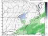
Navgem is a late bloomer for coastal.
View attachment 16860
Too bad you can't see the classified version!!
")
NBAcentel
Member
stronger PV lobe this run

Snowflowxxl
Member
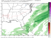
GFS give ATL some very light snow this run
NBAcentel
Member
So happy this is not a apps runner this run

Snowflowxxl
Member
Yep I still like that look better than it showing us all getting a ton of snow right now.

NBAcentel
Member
That’s a pretty significant change at that range (H5), big lobe/ULL in Canada stronger/south this run and still a positively tilted trof, I’d take that at this range

Storm5
Member
By 12z tomorrow it will be a mid Atlantic jackpot
Sent from my iPhone using Tapatalk

NBAcentel
Member
Fv3 is similar to the GFS
ATLwxfan
Member
GFS give ATL some very light snow this run
I got that 2014 feeling.
Sent from my iPhone using Tapatalk
Looks like more bang for our buck on the GEFS tonight .. at least a good run for North Carolina it looks like but I don’t know about others
#WINNING lmao

NBAcentel
Member
Please get ensemble 11, 13, 17 outa here 
Looks worse than 18zLooks like more bang for our buck on the GEFS tonight .. at least a good run for North Carolina it looks like but I don’t know about others

Yes just to clarify for everyone 00z GEFS snow mean took a step back. Although I really don’t give much credence to ensemble snow means bc I think they’re extremely misleading in both directions
Based on the individual maps, I think the snow mean took a step back because there are actually more amped up members. Surprised that it's lower than 18z though!
NBAcentel
Member
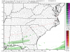
Trof axis moved west, Again, altho it’s stronger this run but it need to stop or the MA will win  slightly more suppressed here, probably due to more influence from that bombing low around Newfoundland but high pressure is weaker
slightly more suppressed here, probably due to more influence from that bombing low around Newfoundland but high pressure is weaker Idk I saw a lot of fish snow on the individual maps. That tells me the coastal idea is alive and well
NBAcentel
Member
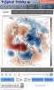
Something interesting has caught my eye on the 00z euro ... tell me if u see the difference
Poor mans block/ridging over Greenland
Yeah, I was about to say, stronger heights over Greenland, perhaps as a result of a sharper defined trough over the North Atlantic?
NBAcentel
Member
Yeah, I was about to say, stronger heights over Greenland, perhaps as a result of a sharper defined trough over the North Atlantic?
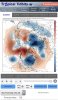
I guess that sharp trough/Lobe is acting in some way to shorten the wavelength with northern stream/PJ allowing some ridging over Greenland, like how a 50/50 low would basically do? Ridging over Greenland typically means your gonna get a amped or stronger storm to develop as it slows the northern stream but can also slow the southern stream which argues amplification
... Uhhh Euro is reloading the pattern ...
I guess that sharp trough/Lobe is acting in some way to shorten the wavelength with northern stream/PJ allowing some ridging over Greenland, like how a 50/50 low would basically do? Ridging over Greenland typically means your gonna get a amped or stronger storm to develop as it slows the northern stream but can also slow the southern stream which argues amplification
With that development, I might be a bit surprised it's still just as suppressed on the OP, but I think the stronger PV cancelled out the rising heights over Greenland. Will be interesting to see if there's more amped up solutions on the EPS (it seemed to me like the GEFS was kindof hinting at this a bit).
And it’s that extra blocking over Greenland that helps push another lobe of cold down giving us maybe another shot?
NBAcentel
Member
And it’s that extra blocking over Greenland that helps push another lobe of cold down giving us maybe another shot?
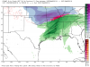
I got TT maps lol but it appears there a system in Texas with a high** squishing it atm
NBAcentel
Member
Also some of that ridging on Greenland appears to be coming from the WAR
NBAcentel
Member
Lol spellcheck really changed high to hug
NBAcentel
Member
EPS is more suppressed, GEFS vs EPS, something in between seems reasonable atm.... that bombing low near Newfoundland is definitely affecting this storm


accu35
Member
Most members on 6z has moisture further north, even tho the OP looked horrible. 12z will give us a new look.

accu35
Member
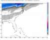
Here's another frame. I'm still watching for this one

I think we've got time. If the trend starts today I'd be worried its early, I'd rather it start at 12z tomorrow or 0z Saturday. Plus, we've seen how much it can change in one runI do believe the folks yesterday worried this would trend too far NW better start pulling in the other direction...