• Hello, please take a minute to check out our awesome content, contributed by the wonderful members of our community. We hope you'll add your own thoughts and opinions by making a free account!

March 24th Severe weather threat

Myfrotho704_

Professional asshole
Member
Joined
Oct 15, 2018
Messages
32,002
Reaction score
93,925
Location
Concord NC
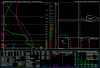
Soundings today look supportive of large/damaging hail with solid CAPE with low freezing levels/cold 500mb temps, strong mid level flow, and isolated tornadoes today seem possible given the low level hodograph curvature, it’s also a good day if your chasing for structure given the bit of LFC/LCL seperation (CIN) and llvl hodo curvature (stacked/laminar/striated structures)
Forecast Soundings before storms fire E1319857-3A38-4D59-9EFC-99F7046C31FA.png8CF228EC-50E4-4675-A62F-B2E212D2921E.png
 
looks like we’re gonna luck out in NC with elevated thunderstorms from MUCAPE, altho some storms could have small hail, hopefully the CAD doesn’t erode further north because wind profiles are quite impressive, may see a 1-2 elevated supercells closer to the CAD boundary like the HRRR/NAM show DCC73CC5-1CF1-4DC4-98F6-46E5ACF83929.png
 
Yeah have to figure the HRRR is probably over mixing and eroding the CAD a bit too quickly, the tor threat here will be limited by the slow deep layer flow, lack of low-level instability due to preceding convection and stratiform precip (which usually over performs) and poor low-level lapse rates underneath the dome. Localized flash flooding and hail are the main threats in NC today imo
 
Yeah have to figure the HRRR is probably over mixing and eroding the CAD a bit too quickly, the tor threat here will be limited by the slow deep layer flow, lack of low-level instability due to preceding convection and stratiform precip (which usually over performs) and poor low-level lapse rates underneath the dome. Localized flash flooding and hail are the main threats in NC today imo

At this point a something as simple as a thunderstorm passing over would relieve stress from COVID-19, lol
 
Do think there’s a good shot for a few tornadoes, maybe a strong one, first real setup with actually low level instability which allows mesocyclones to punch down to the sfc and produce, and ofc you got those nice curved hodographs 1929CCFF-1F26-4243-802B-2D7CD4910229.png
 

Attachments

  • B2F2B376-CE7C-4339-B337-2E519AB260CC.png
    B2F2B376-CE7C-4339-B337-2E519AB260CC.png
    235.8 KB · Views: 9
Back
Top