with >95% probs!!! Holy crap.
-
Hello, please take a minute to check out our awesome content, contributed by the wonderful members of our community. We hope you'll add your own thoughts and opinions by making a free account!
You are using an out of date browser. It may not display this or other websites correctly.
You should upgrade or use an alternative browser.
You should upgrade or use an alternative browser.
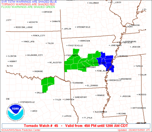
Severe March 14-17 Severe
- Thread starter SD
- Start date
Mahomeless
Member
- Joined
- Oct 17, 2023
- Messages
- 900
- Reaction score
- 2,158
The line in MS is dang near stationary...continuing to allow rapid destabilization across AL. As the SLP begins to crank in AR, and the forcing begins east, it will get ugly real quick!
Rolltidegal60
Member
The forecast has not changedReally good trend for AL in the short term. The more the dps mix down the more time it takes to moisten back up.
View attachment 171818
ChattaVOL
Member
Sun starting to come out in Chattanooga.

Sent from my iPhone using Tapatalk

Sent from my iPhone using Tapatalk
Psalm 148:8
Member
- Joined
- Dec 25, 2016
- Messages
- 345
- Reaction score
- 792
If you are gonna call someone out, make sure you are a meteorologist! TWC Mets showed this to be possible in east Alabama.. where he is.. and west Ga where I am.. I’m certain a real met might be more qualified than you to call someone out.. no idea how long you’ve been around.. but ARCC and I were on a different forum long ago before this one ever started. And I’ve found him to be pretty knowledgeable.. in the event I missed your credentials please feel free to pm me.There is clearly an agenda by @Arcc to wishcast a diminished threat in AL.....do not buy into it at all! Latest Meso Discussion clearly lays out the biggest threat we have seen in over a decade. Please get you information from informed experts!!!
Belle Lechat
Member
- Joined
- Aug 29, 2021
- Messages
- 1,547
- Reaction score
- 1,224
1026 AM CDT SAT MAR 15 2025
THE NATIONAL WEATHER SERVICE IN JACKSON HAS ISSUED A
* TORNADO WARNING FOR...
SOUTHEASTERN SUNFLOWER COUNTY IN NORTHWESTERN MISSISSIPPI...
SOUTHWESTERN LEFLORE COUNTY IN NORTH CENTRAL MISSISSIPPI...
SOUTHEASTERN WASHINGTON COUNTY IN NORTHWESTERN MISSISSIPPI...
HUMPHREYS COUNTY IN CENTRAL MISSISSIPPI...
NORTHEASTERN SHARKEY COUNTY IN WEST CENTRAL MISSISSIPPI...
* UNTIL 1130 AM CDT.
* AT 1026 AM CDT, A LARGE AND EXTREMELY DANGEROUS TORNADO WAS LOCATED
NEAR GRACE, OR NEAR MAYERSVILLE, MOVING NORTHEAST AT 45 MPH.
THIS IS A PARTICULARLY DANGEROUS SITUATION. TAKE COVER NOW!
HAZARD...DAMAGING TORNADO.
SOURCE...RADAR INDICATED ROTATION.
IMPACT...YOU ARE IN A LIFE-THREATENING SITUATION. FLYING DEBRIS
MAY BE DEADLY TO THOSE CAUGHT WITHOUT SHELTER. MOBILE
HOMES WILL BE DESTROYED. CONSIDERABLE DAMAGE TO HOMES,
BUSINESSES, AND VEHICLES IS LIKELY AND COMPLETE
DESTRUCTION IS POSSIBLE.
* THE TORNADO WILL BE NEAR...
ANGUILLA, PANTHER BURN, AND NITTA YUMA AROUND 1030 AM CDT.
DELTA CITY AROUND 1035 AM CDT.
HOLLANDALE AROUND 1040 AM CDT.
MURPHY AROUND 1045 AM CDT.
BELZONI AND ISOLA AROUND 1100 AM CDT.
SWIFTOWN AROUND 1110 AM CDT.
Belle Lechat
Member
- Joined
- Aug 29, 2021
- Messages
- 1,547
- Reaction score
- 1,224
1035 AM CDT SAT MAR 15 2025
THE NATIONAL WEATHER SERVICE IN NEW ORLEANS HAS ISSUED A
* TORNADO WARNING FOR...
EAST CENTRAL WILKINSON COUNTY IN SOUTHERN MISSISSIPPI...
NORTHWESTERN AMITE COUNTY IN SOUTHERN MISSISSIPPI...
* UNTIL 1115 AM CDT.
* AT 1034 AM CDT, A SEVERE THUNDERSTORM CAPABLE OF PRODUCING A
TORNADO WAS LOCATED NEAR WOODVILLE, OR 20 MILES NORTH OF JACKSON,
MOVING NORTHEAST AT 40 MPH.
HAZARD...TORNADO
1034 AM CDT SAT MAR 15 2025
THE NATIONAL WEATHER SERVICE IN MEMPHIS HAS ISSUED A
* TORNADO WARNING FOR...
LAFAYETTE COUNTY IN NORTHWESTERN MISSISSIPPI...
YALOBUSHA COUNTY IN NORTHWESTERN MISSISSIPPI...
EAST CENTRAL TALLAHATCHIE COUNTY IN NORTHWESTERN MISSISSIPPI...
SOUTHEASTERN PANOLA COUNTY IN NORTHWESTERN MISSISSIPPI...
* UNTIL 1115 AM CDT.
* AT 1034 AM CDT, A SEVERE THUNDERSTORM CAPABLE OF PRODUCING A
TORNADO WAS LOCATED NEAR PAYNES, OR 9 MILES SOUTHEAST OF
CHARLESTON, MOVING NORTHEAST AT 60 MPH.
HAZARD...TORNADO AND PING PONG BALL SIZE HAIL.
Let’s not get into arguments that take up pages of the thread today please. There’s a potentially historic tornado outbreak and there are people reading this forum to help make decisions about protecting lives and property.
Where does this come from?
Brent
Member

The forecast has not changed
No it hasn't and no one should treat it such and should listen to the SPC and their respective NWS offices. However, this is a weather forum and we discuss things we are seeing.
Machine learning tool that’s done pretty well the past few years. It’s gained a good following on Twitter (X)Where does this come from?
Thanks. Where can you access it?Machine learning tool that’s done pretty well the past few years. It’s gained a good following on Twitter (X)
JMB
Member
Exactly. Dude is attacking anyone that says anything slightly positive.@Mahomeless is a clown. Calling us trolling for stating exactly what the models are showing.
As far as I know the forecasts are just posted on X a couple of times a dayThanks. Where can you access it?
Belle Lechat
Member
- Joined
- Aug 29, 2021
- Messages
- 1,547
- Reaction score
- 1,224
we’ve still got cloud coverage here but it is getting noticeably thinner and brighter in the high sun.Exactly. Dude is attacking anyone that says anything slightly positive.
And don’t pay Mahomeless any attention. He’s easily a top 5 winter weather troll on here. Posting positives is helpful because storm anxiety is at a peak right now.
Twister
Member
We will take any little positives we can get. Hopefully it's not gonna be to severe for us here in upstatewe’ve still got cloud coverage here but it is getting noticeably thinner and brighter in the high sun.
And don’t pay Mahomeless any attention. He’s easily a top 5 winter weather troll on here. Posting positives is helpful because storm anxiety is at a peak right now.
Belle Lechat
Member
- Joined
- Aug 29, 2021
- Messages
- 1,547
- Reaction score
- 1,224
1059 AM CDT SAT MAR 15 2025
THE NATIONAL WEATHER SERVICE IN JACKSON HAS ISSUED A
* TORNADO WARNING FOR...
LINCOLN COUNTY IN SOUTH CENTRAL MISSISSIPPI...
SOUTHEASTERN JEFFERSON COUNTY IN SOUTHWESTERN MISSISSIPPI...
FRANKLIN COUNTY IN SOUTHWESTERN MISSISSIPPI...
* UNTIL NOON CDT.
* AT 1058 AM CDT, A SEVERE THUNDERSTORM CAPABLE OF PRODUCING A
TORNADO WAS LOCATED 8 MILES SOUTH OF MEADVILLE, MOVING NORTHEAST AT
45 MPH.
Watch this area in the coming hour or so.

RTRwx
Member
The HRRR is continuing to cluster developing supercells into some messy convection. Radar trends back this up. Good trend.
Definitely encouraging radar trends back west so far and many are starting to point that out more and more on X.
Still going to be some bad storms and chance at large tornadoes, but we all will take a more linear threat with embedded cells rather then discrete cells. We have a long ways to go but all of us to east should see what actually produces in MS.
It only takes one storm and one life lost for it to be your problem.
Just a spectator here but does it seem like the convection is more of a line than supercelluar like models showed yesterday?
The WRFs and FV3 pretty much showed a messy evolution yesterday.
rburrel2
Member
The velocity scan with that western MS tornado looked exceptionally violent. Any damage reports?
NBAcentel
Member
Messy. SW flow doing SW flow things 

lj0109
Member
Sharkey County EMA (updated) now reporting NO injuries but damage around the Grace Community with that cell that moved through earlier.1026 AM CDT SAT MAR 15 2025
THE NATIONAL WEATHER SERVICE IN JACKSON HAS ISSUED A
* TORNADO WARNING FOR...
SOUTHEASTERN SUNFLOWER COUNTY IN NORTHWESTERN MISSISSIPPI...
SOUTHWESTERN LEFLORE COUNTY IN NORTH CENTRAL MISSISSIPPI...
SOUTHEASTERN WASHINGTON COUNTY IN NORTHWESTERN MISSISSIPPI...
HUMPHREYS COUNTY IN CENTRAL MISSISSIPPI...
NORTHEASTERN SHARKEY COUNTY IN WEST CENTRAL MISSISSIPPI...
* UNTIL 1130 AM CDT.
* AT 1026 AM CDT, A LARGE AND EXTREMELY DANGEROUS TORNADO WAS LOCATED
NEAR GRACE, OR NEAR MAYERSVILLE, MOVING NORTHEAST AT 45 MPH.
THIS IS A PARTICULARLY DANGEROUS SITUATION. TAKE COVER NOW!
HAZARD...DAMAGING TORNADO.
SOURCE...RADAR INDICATED ROTATION.
IMPACT...YOU ARE IN A LIFE-THREATENING SITUATION. FLYING DEBRIS
MAY BE DEADLY TO THOSE CAUGHT WITHOUT SHELTER. MOBILE
HOMES WILL BE DESTROYED. CONSIDERABLE DAMAGE TO HOMES,
BUSINESSES, AND VEHICLES IS LIKELY AND COMPLETE
DESTRUCTION IS POSSIBLE.
* THE TORNADO WILL BE NEAR...
ANGUILLA, PANTHER BURN, AND NITTA YUMA AROUND 1030 AM CDT.
DELTA CITY AROUND 1035 AM CDT.
HOLLANDALE AROUND 1040 AM CDT.
MURPHY AROUND 1045 AM CDT.
BELZONI AND ISOLA AROUND 1100 AM CDT.
SWIFTOWN AROUND 1110 AM CDT.
We are up to 80 degrees here about 10 miles south of Birmingham.
Mahomeless
Member
- Joined
- Oct 17, 2023
- Messages
- 900
- Reaction score
- 2,158
PDS Watch incoming across much of AL....they know what's about to happen.We are up to 80 degrees here about 10 miles south of Birmingham.
JimRussell
Member
This is feeling messy to my untrained weenie eyes
Very impressive DP mixing across Central AL. Makes sense considering the SE surface wind. They will come up eventually, but definitely helps in the short term.

I'm not totally sold on a primarily linear convective mode here. I wouldn't be shocked to see this initial mass roll through Ms into NW Al then through TN with potentially more discrete activity along and S of a lingering TMB.
I’d watch this cell south of Mccomb, MS. Seems to be separating a bit and moving with bit more east compliment as it does

Mahomeless
Member
- Joined
- Oct 17, 2023
- Messages
- 900
- Reaction score
- 2,158
lol…doesn’t help a thing when there is no forcing in the area. Everything is setting up EXACTLY as forecasted by the SPCVery impressive DP mixing across Central AL. Makes sense considering the SE surface wind. They will come up eventually, but definitely helps in the short term.
View attachment 171826
Mahomeless
Member
- Joined
- Oct 17, 2023
- Messages
- 900
- Reaction score
- 2,158
Storm mode beginning to go discrete in MS…heading for a ripe environment in AL.