• Hello, please take a minute to check out our awesome content, contributed by the wonderful members of our community. We hope you'll add your own thoughts and opinions by making a free account!

Tropical Major Hurricane Milton

Really feeling the shear now, still powerful storm but getting lopsided quick. If any dry air can penetrate it could see rapid weakening, could still be a Cat 4 at LF too, but hopeful it can weaken quickly on approach
Yeah I was about to say the same thing. The NW side of the COC is taking a beating. If that continues, and it looks like it should, it's hard to see how it will be more than a Cat 3 at landfall.

That said, the wind field will still be big, and the surge will be destructive, not to mention all of the rain that has fallen and will fall.
 
I'd be cautious about attributing the current degradation in satellite images to shear and dry air. An EWRC has begun with the outer concentric eyewall already at 125 knots. How this eyewall replacement evolves this morning before the shear ramps up will matter greatly regarding landfall intensity as well as how far north the storm goes.
 
Yeah I was about to say the same thing. The NW side of the COC is taking a beating. If that continues, and it looks like it should, it's hard to see how it will be more than a Cat 3 at landfall.

That said, the wind field will still be big, and the surge will be destructive, not to mention all of the rain that has fallen and will fall.
Interesting it looks as if an EWRC is beginning, maybe just maybe with the ongoing shear it becomes vulnerable to some dry air intrusion during this cycle. Like you said still gonna be a destructive storm but hopefully it will be minimized somewhat compared to a LFing cat 5 anyway 🙏
 
I'd be cautious about attributing the current degradation in satellite images to shear and dry air. An EWRC has begun with the outer concentric eyewall already at 125 knots. How this eyewall replacement evolves this morning before the shear ramps up will matter greatly regarding landfall intensity as well as how far north the storm goes.
You may be right. Whenever I see a well-structured, mature hurricane become lopsided, it makes me think that shear is playing a role. But the ERC will have a negative effect as well. Hopefully, all of this means significant weakening into landfall.
 
Radar and recon clearly show concentric eyewalls. The inner eye is still quite robust. Hopefully, this EWRC occurs slowly chocking off the inner eye rather than a meld. The longer this cycle takes, the more susceptible the storm will be to the shear forecasts to dramatically increase later today.
Note the sharp secondary wind maximums from the last pass.
1728478771918.png
 
You may be right. Whenever I see a well-structured, mature hurricane become lopsided, it makes me think that shear is playing a role. But the ERC will have a negative effect as well. Hopefully, all of this means significant weakening into landfall.

No doubt shear is pounding it’s NW side ATM.
 
It looks like pressure is up substantially. 940s ?
View attachment 153033

I’d love to think so, but I saw this elsewhere suggesting that’s not the center:

“Recon passed about 8 - 10 miles south of the eye, lowest pressure was 941.6 mb extrapolated with 107 kt winds.”
 
I’d love to think so, but I saw this elsewhere suggesting that’s not the center:

“Recon passed about 8 - 10 miles south of the eye, lowest pressure was 941.6 mb extrapolated with 107 kt winds.”
Ah. I can see that now too.
 
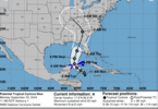
Short-term radar fixes indicate the anticipated NNE movement has commenced. How much latitude and forward speed Milton gains during the day before the bend back east will be critical for the Tampa area.

Trochoidal wobble/uneven convection very likely causing this. It should correct back to NE within a couple of hours per models. Then it may temporarily go to a NNE heading again, etc.
 
Back
Top