Twister
Member
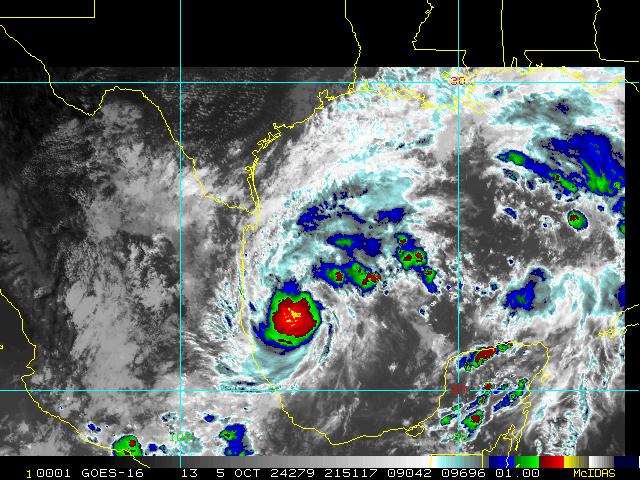
Anybody know how big Milton is?
Sent from my SM-S911U using Tapatalk
Sent from my SM-S911U using Tapatalk
Thanks, Shaggy. This is the last guess. Contest deadline has just passed. There are 13 entrants. Winner gets a free paid cruise into the eye of the next cat 5. An infinite amount of Dramamine will be provided. Also, an attorney will be available in case the winner doesn’t have a will.
Yeah don’t see this thing getting hurt to much by little dry air on its approach towards Florida …. Waters are like bath water also ,easily seeing a 140. 145 mph type cane at Landfallthis is just my personal opinion but none of these models have done a good job as far as strength goes. This thing has really blown most out of them out of the water and has been stronger than even the lowest hurricane models. There will be weakening on approach but I think we are really underestimating just how strong and resilient this thing is going to be to dry air and shear.


Anybody know how big Milton is?
Sent from my SM-S911U using Tapatalk


I consider myself a reasonably intelligent person, but still trying to figure out ACE and this helped ...not!"The ACE index is calculated using the formula ACE = 10-4Σv2, where v is the estimated sustained maximum wind speed in knots. The resulting figure is divided by 10,000 to make it more manageable"


Better for Tampa, bad for SarasotaOn the S side of the models
View attachment 152955
Pretty decent in the middle of the GEFS
View attachment 152956
This is already lower than the Hwrf, hmon, and both Hafs forecasted for tomorrow.This is just crazy at this point. Almost into the top hurricanes for a second time
The minimum central pressure estimated from Hurricane Hunter
aircraft observations is 902 mb (26.64 inches).

Wasn't there one storm that completely walled off the Dry air upon landfall and barely weakened? I think there was one, but can't remember the name of it.I'd give Milton another 6 to 9 hours before we see another ERC occur given the pressure changes, eye down to 9 miles again, and microwave imagery building up again outside the eyewall. Whether this will shred the storm or give it enough time afterwards has yet to be seen but I'd be concerned if the dry air can't get deep into the storm by landfall.
Bet that last pass into the NE eyewall is gonna have some crazy wind speeds

It's that blob to the NE of the storm I'm more worried about continuing to reinforce what is lost on the W side as it pulls north. A lot of that may fade but it still has a good moisture feed, which is likely what made it blow back up after almost losing its eyewall earlier on satellite. The ERC speed seems fast with this storm too.Wasn't there one storm that completely walled off the Dry air upon landfall and barely weakened? I think there was one, but can't remember the name of it.

I’ve tracking the water vapor images for the last few hours and despite all the dry air to the north and west of the storm it’s just showing no signs of effecting any time soon. The outflow is still about perfect to the north and west.I'd give Milton another 6 to 9 hours before we see another ERC occur given the pressure changes, eye down to 9 miles again, and microwave imagery building up again outside the eyewall. Whether this will shred the storm or give it enough time afterwards has yet to be seen but I'd be concerned if the dry air can't get deep into the storm by landfall.

It typically seems strength forecasting for hurricanes is one of the things NWP struggles the most with.this is just my personal opinion but none of these models have done a good job as far as strength goes. This thing has really blown most out of them out of the water and has been stronger than even the lowest hurricane models. There will be weakening on approach but I think we are really underestimating just how strong and resilient this thing is going to be to dry air and shear.
Is this the end for strengthening?The pressure has slowly been rising since the planes arrived. I suspect they arrived just past Milton's afternoon peak.
View attachment 152976

Maybe. The storm will soon be aided for a time by diffluence from the jet stream over the Gulf States and NW GOM so I can see it making one more run at it by morning.Is this the end for strengthening?