• Hello, please take a minute to check out our awesome content, contributed by the wonderful members of our community. We hope you'll add your own thoughts and opinions by making a free account!

Tropical Major Hurricane Maria

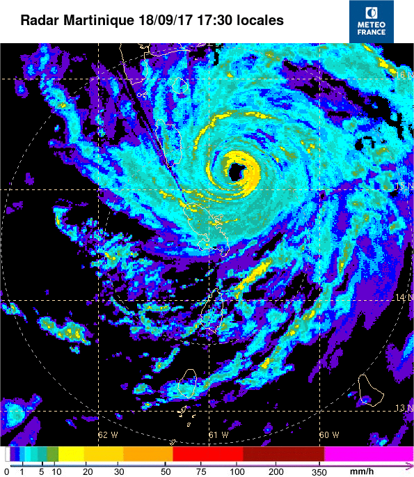
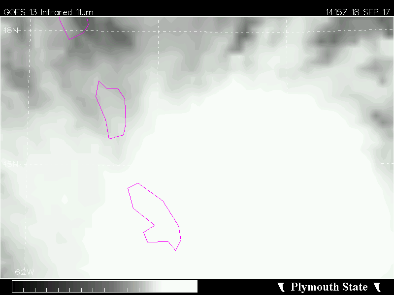
Looked like there was a bit of northerly shear from a small mid level ridge off to it's NNW and also some outflow boundaries evident in the NE bands this morning indicative of some drier air. The outflow is now beginning to expand nicely in those areas so there really is nothing of note to keep it from bombing out other than internal processes. And these small storms don't always behave internally as larger ones.
 
Ukie ensembles mostly east also although there are a few that threaten the eastern seaboard most do not
Capture.png
 
Ukie ensembles mostly east also although there are a few that threaten the eastern seaboard most do not
Capture.png
I know it's a long way to go but the Euro and the Ukmet along with Jose holding it's own has me feeling a little better about this missing the US...
 
Dreaded pinhole eye mentioned in discussion plus a 155 mph peak and mentioning a cat 5 possible
 
I know it's a long way to go but the Euro and the Ukmet along with Jose holding it's own has me feeling a little better about this missing the US...
Jose looks pretty horrible and he's degraded a lot faster than forecast. We should find out soon enough precisely how strong he is but I don't think he's either fully tropical at the moment nor still a hurricane. While there's still a strong diabatic PV tower in the low-mid troposphere with Jose, stratospheric extrusions of PV are becoming evident over the circulation and have effectively linked up with the lower level PV tower... Definitely at least subtropical
 
So...I figure until the models figure out that Jose is not nearly as strong as they think they are they're going to struggle. :\
 
Keep in mind with Irma, satellite intensity estimates severely underestimated its intensity... When recon found her to be a 145 kt category 5, satellite intensity estimates only supported a 120 kt cat 4. While Maria is a totally different storm, the underestimation bias from satellites is consistent with small TCs undergoing RI like Maria, and even these notoriously conservative estimates support a 125 kt category 4 hurricane with Maria rn, & for the NHC to go considerably lower than the satellites it's head scratching...
 
Keep in mind with Irma, satellite intensity estimates severely underestimated its intensity... When recon found her to be a 145 kt category 5, satellite intensity estimates only supported a 120 kt cat 4. While Maria is a totally different storm, the underestimation bias from satellites is consistent with small TCs undergoing RI like Maria, and even these notoriously conservative estimates support a 125 kt category 4 hurricane with Maria rn, & for the NHC to go considerably lower than the satellites it's head scratching...
It's quite confusing indeed. Looking at the current estimates, she is strengthening fast still, and I bet that recon will find cat 5 in this flight. If they do find and issue the 8 pm advisory saying a mid cat 4, they likely have their head in a bucket.
15LP.GIF
 
Jose looks pretty horrible and he's degraded a lot faster than forecast. We should find out soon enough precisely how strong he is but I don't think he's either fully tropical at the moment nor still a hurricane. While there's still a strong diabatic PV tower in the low-mid troposphere with Jose, stratospheric extrusions of PV are becoming evident over the circulation and have effectively linked up with the lower level PV tower... Definitely at least subtropical
I'm certainly not one to argue with you Webb lol.... I agree completely it's not looking that great but does Jose need to remain a tropical system in order for it to affect the steering currents? In other words if it's there post-tropical won't it still have effects on breaking that ridge down

Sent from my SM-G920V using Tapatalk
 
This run is likely OTS but I'm not sure these runs really matter much when the pressures get initialized way off, that could be the difference between well OTS and a landfall.
 
My experience, especially this season, has shown me that even the Euro is struggling with storm intensity. Considering the evolution of Maria is highly dependant on what Jose does, we can't take any of these operational model runs to heart. With the ensemble suites showing a clear Northward movement, and Maria missing Hispaniola for the most part, I'm sticking with that idea currently.

Larry's research has shown that most, if not all, tropical cyclones head away from the United States when they have another tropical cyclone to their North.
 
Larry's research has shown that most, if not all, tropical cyclones head away from the United States when they have another tropical cyclone to their North.
Well, it's the year storms defy climo, so all logic can be defied. No storms up to Irma were cat 5 185 monsters near the Antilles, until Irma. However, if we see no Jose in a few days, that rule goes out the door anyway.
 
Well, it's the year storms defy climo, so all logic can be defied. No storms up to Irma were cat 5 185 monsters near the Antilles, until Irma. However, if we see no Jose in a few days, that rule goes out the door anyway.
I brought it up in my previous post, because it looks like the majority of ensembles from the various models are having Jose play a factor in Maria's track. Not to say, that won't change.

Edit:
I'd like to see a more robust upper level low in the Southeast region to get Maria into here.
 
Well, next frame and no ERC chance now. Just more power to the eyewall. Meanwhile, T values continue to climb. 5.9 Adjusted, 7.3 raw. Clouds look really healthy at the moment.
 
Just by the eyes, I'm not sure how Jose is still being considered a hurricane. It may still have winds that are close but it really is not looking that good.
 
Raw t numbers keep on rising, they're now up to 7.4, which would make Maria a 155 knot (180 mph) category 5 hurricane. This recon mission will be very telling wrt its intensity. Not sure if it's that high, but these satellite estimates are going off the charts
 
Satellite numbers tend to under-do intensity. We could see some scary numbers on the incoming recon data soon.
 
Probably the most powerful surface wind since Wilma in the Atlantic.

I can't imagine what that Island will receive.
 
It is entirely possible, with current conditions, that Maria could make a run at Hurricane Allen's 190 MPH maximum wind speed. Hurricane Allen holds the record, if I'm not mistaken, in the Atlantic.
 
It is entirely possible, with current conditions, that Maria could make a run at Hurricane Allen's 190 MPH maximum wind speed. Hurricane Allen holds the record, if I'm not mistaken, in the Atlantic.
Yes, Allen was 190 mph, so it's possible. I am sure the pressure is probably around 930mb right now or just above given the small eye maintaining itself.
 
Back
Top