• Hello, please take a minute to check out our awesome content, contributed by the wonderful members of our community. We hope you'll add your own thoughts and opinions by making a free account!

Tropical Major Hurricane Maria

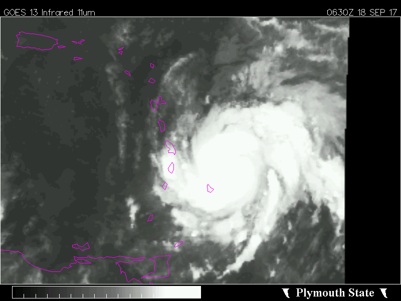
The ridging on the Canadian must be overdone. Jose slips through to the North and the ridging builds in, very very strongly right after. GFS starts to break the ridging down too quickly, as a known bias. Euro will be good tonight.

Yeah, looks like it will squeak OTS on the GFS from a result of the dampering of ridging and the help of the ghost of Jose. Like you said the Euro will be very telling.
 
Seriously, look at the Canadian. This is hysterical.

gem_z500a_Norm_watl_32.png
 
Yeah, looks like it will squeak OTS on the GFS from a result of the dampering of ridging and the help of the ghost of Jose. Like you said the Euro will be very telling.

Then again, the GFS may want to tug it inland.
 
yeah on the CMC Jose is as strong as he is now east of Bermuda, I had to loop it 3 times to believe it was Jose

See I figured with Maria going to SC Jose had to be dead

I was wrong lol
 
Until Maria reaches this point just near or just north of Hispaniola in about 5 days, we won't have any truly telling information regarding a specific threat to the US, because until then most of the main features (Maria herself, Jose, Hispaniola's possible cyclonic track deflection of Maria, the planetary wave configuration over top of Maria and Jose) are still far too uncertain to assess the true threat this poses to the US (if at all)... The biggest wild card of them all may end up being interaction w/ Hispaniola (as is often the case if a TC strays too close to the island) and that won't be resolved until Wednesday Night/Thursday at the very earliest.
ecmwf-ens_z500a_watl_6.png
 
gotta think to, where is Maria when she turns north? If she's very far west of the GFS it won't matter, she'll still hit the Carolinas

the CMC for example is over the Bahamas not east and it hits

I agree, we won't really know much til it clears Hispanola
 
You have to wonder if Jose makes it long at all, failing rapidly on IR.

the water is cold up there(heard it's below normal), I've always been skeptical tbh

Heck its not even in the cold water yet(that's closer to New England in a couple days) and already going downhill

I'm having a hard time believing it survives the week, its only Monday morning lol

Also the GFS has STRENGTHENING of Jose approaching Cape Cod which makes me doubt the whole run
 
Last edited:
now the Euro is strengthening Jose from 970s to 950s in 48 hours

Why??? It is clearly not going to strengthen looking at the satellite

Euro looks like a visit to the Shredder at 72

and at 96 it STRENGTHENS Maria 20 mb as it's passing very near the Shredder:rolleyes:
 
Last edited:
0Z Euro looks like another recurve east of the US east coast based on hour 144.
 
yep Jose STILL leaving a weakness

but I seriously wonder if Jose will be alive in a week
 
Maria is going to hookup with whatever is left of Jose and possibly absorb him with a ridge overhead. This should be yet, another solution.
 
I give up, I don't even know what the Euro is doing

I have major doubts Jose is even alive much less this nonsense

at 192 it looks like Maria has ate Jose lol
 
Looks like Maria is going to "sling" Jose (somehow) into the VA/NC area and then come on in behind on future frames at some part of the USA. Weird run. Ridging breaking down by this time.
 
why am I still waiting up for these frames I don't know

OTS at 216

but I seriously question the Jose interaction
 
Last edited:
Can't make this run up, whatever is left of Jose heads down into NC while Maria travels Northeastward (Maine isn't out of the woods, I guess). Looking back at it, Maria doesn't really sling Jose in so much as the ridging makes him come into the East coast and then Maria follows the path of least resistance in a sense.
 
And by 240, she sweeps OTS and Jose (remnants) come off the coast of NC with an approaching frontal type thing. This run did nothing to help us get any information, lol.

Edit: Ensembles should be a hoot!
 
With regards to Jose saving the EC, it's looking very,very unorganized this AM! Tropical storm like on satellite !
 
Well, GFS kills Jose and tries to send Maria right into a ridge. Well played, GFS. Thanks for being of no help; Again!

Edit: Looking like she'll have a possible escape route, OTS.
 
Maria has been moving due west for several hours. Unless a northern component starts soon, the shredder will get it.
 
By the way, here is the 00z EPS:
AL15_2017091800_ECENS.png
 
I think west is still a very real possibility, once again models are underestimating the westerlies that are driving Maria and as arcc just mentioned this has Hispaniola aka the shredder written all over it. With that you'd have a weaker west bound TC not to mention I don't think models have a clue on what the outflow from Maria will be doing to Jose either...i just don't buy the ots solution right now.

Sent from my SM-G920V using Tapatalk
 
I'd also be leery of just about anything that GFS spits out trackwise right now especially a track that is dependent upon a tropical system, Jose, breaking down a ridge. Just keep in mind how insane the GFS has been with pressure falls of tropical systems all year

Sent from my SM-G920V using Tapatalk
 
The ECMWF is forecasting Jose to undergo significant strengthening in the next 24 hours into a 963 hPa borderline category 1-2 hurricane as he passes over the Gulf Stream. Monitoring these short term intensity forecasts will be key for Jose and Maria's future down the road as it will determine how much of a weakness he may leave in the ridge north of Maria
 
Extrapolated MSLP on the 1st pass thru Maria's center is ~ 965 hPa, given the dropsondes have usually been a few mb higher Maria is probably ~970 hPa at the moment. Unflagged SFMR winds of ~100 knots were also found in the northeastern quadrant of the storm which if correct would make Maria a category 3 hurricane
recon_AF305-0215A-MARIA_timeseries.png
 
Extrapolated MSLP on the 1st pass thru Maria's center is ~ 965 hPa, given the dropsondes have usually been a few mb higher Maria is probably ~970 hPa at the moment. Unflagged SFMR winds of ~100 knots were also found in the northeastern quadrant of the storm which if correct would make Maria a category 3 hurricane
View attachment 1293
There's the surprise! She is definitely a monster if they confirm and use it in the next advisory.
 
The ECMWF is forecasting Jose to undergo significant strengthening in the next 24 hours into a 963 hPa borderline category 1-2 hurricane as he passes over the Gulf Stream. Monitoring these short term intensity forecasts will be key for Jose and Maria's future down the road as it will determine how much of a weakness he may leave in the ridge north of Maria
Jose looks like extra tropical doo doo this AM! Would be shocked to see this strengthen to a Cat 2! The Gulf Stream is not that magical, when it's surrounded by all tha cool water, every time a storm is about to hit NC, they always think it's just going to jump 2 categories higher because it crosses the Gulf Stream , and that's not the case , most of the time!
 
The ECMWF is forecasting Jose to undergo significant strengthening in the next 24 hours into a 963 hPa borderline category 1-2 hurricane as he passes over the Gulf Stream. Monitoring these short term intensity forecasts will be key for Jose and Maria's future down the road as it will determine how much of a weakness he may leave in the ridge north of Maria

Yeah the Euro might be way too strong in the short term, much less any further intensification to begin with, given Jose's center is nearly devoid of any convection as he faces 50 knots of west-southwesterly wind shear. Recon is finding his MSLP to be ~975 hPa...

On another note, NHC goes w/ 110 mph at the 8am advisory despite the 102 KT unflagged SFMR of 102 KT and 108 KT winds in the lowest 150m (which even if they're instantaneous) still argues for 100 KT cat 3. May be upgraded in post season reanalysis.
Either that or after the next pass.probably want confirmation in a second and third drop.
 
Either that or after the next pass.probably want confirmation in a second and third drop.

Yeah, they might but even still the odds they're sampling the strongest possible point in the storm are slim-none, and the dropsonde's measurements are so far & beyond the threshold it definitely leaves me scratching my head esp considering you only need ~97 KTS to classify as a major...
 
Yeah the Euro might be way too strong in the short term, much less any further intensification to begin with, given Jose's center is nearly devoid of any convection as he faces 50 knots of west-southwesterly wind shear. Recon is finding his MSLP to be ~975 hPa...

On another note, NHC goes w/ 110 mph at the 8am advisory despite the 102 KT unflagged SFMR of 102 KT and 108 KT winds in the lowest 150m (which even if they're instantaneous) still argues for 100 KT cat 3. May be upgraded in post season reanalysis.
The GFS is doing the same thing with Jose, diving into the lower 960s while the CMC and NAVGEM seem yo be reasonable on pressures. From how this year has gone, this area seems to be the CMC's area, and with support of the NAVGEM, a sharp curve solution may or may not happen, but if it is weaker than the GFS and euro is expecting it to get, I'm sure Maria will end up further west in some way.
 
So, we're really hoping for Jose to stick around before dying out to send Maria out to sea. That doesn't sound like it's going to be easy to forecast where Maria will go.
 
Either that or after the next pass.probably want confirmation in a second and third drop.

Actually, their 12z ATCF valid at 8am eastern showed Maria was a 100 knot category 3 hurricane, they may not have had enough time to reflect that in their advisory package and given the recon data, I think it's near certain to assume they'll upgrade it to a 3 in post season reanalysis by this time...
 
Back
Top