In meantime say a prayer for PR and surrounding Islands... oh my
-
Hello, please take a minute to check out our awesome content, contributed by the wonderful members of our community. We hope you'll add your own thoughts and opinions by making a free account!
You are using an out of date browser. It may not display this or other websites correctly.
You should upgrade or use an alternative browser.
You should upgrade or use an alternative browser.
Tropical Major Hurricane Maria
- Thread starter Webberweather53
- Start date
pcbjr
Member
Novena started this AM, FWIWIn meantime say a prayer for PR and surrounding Islands... oh my
From Allan Huffman just fyi....
- Joined
- Sep 4, 2017
- Messages
- 216
- Reaction score
- 260
HDOB drops showing some "possible" outer wind maximas forming outside the eye. Keyword is possible. Looking desperately for anything to weaken it somehow before the islands and PR.
Yeah NHC mentions this as well but so far hasn't done anything to halt the strengthening of the inner eyewallHDOB drops showing some "possible" outer wind maximas forming outside the eye. Keyword is possible. Looking desperately for anything to weaken it somehow before the islands and PR.
The aircraft data also indicates that an outer wind maximum is present
about 20-30 n mi from the center, but this has not yet developed
into enough of an outer eyewall to stop the intensification in the
inner eyewall.
- Joined
- Sep 4, 2017
- Messages
- 216
- Reaction score
- 260
Sometimes when the storms are very strong the forming outer eyewall just kinda of contracts inward and merges with the inner eyewallYeah NHC mentions this as well but so far hasn't done anything to halt the strengthening of the inner eyewall
The aircraft data also indicates that an outer wind maximum is present
about 20-30 n mi from the center, but this has not yet developed
into enough of an outer eyewall to stop the intensification in the
inner eyewall.
instead of a full on collapse of the inner eyewall. You end up with the inner eye somewhat bigger than it was and yeah not much if any weakening.
The winds are looking a little weaker in the NE wall on this last pass, based on what Levi's site is showing.
Brent
Member
912.7 extrap
Webberweather53
Meteorologist
Dropsonde reveals a pressure of 913 hPa, Maria's MSLP is lower than Irma's officially...
This is going to be extremely bad for Puerto Rico. Winds will continue to increase as the pressure drops. The last major hit they took was from Hugo way back in 1989.
Sadly, I do not see a sign of an eyewall replacement cycle yet.
Sadly, I do not see a sign of an eyewall replacement cycle yet.
Webberweather53
Meteorologist

Maria now holds sole possession of 12th place on the Atlantic's all time lowest Mean Sea Level Pressure (MSLP) list for tropical cyclones if the 913 hPa minimum central pressure stands (which it likely will). Strongest since Hurricane Dean (2007) & Wilma (2005)...

Last edited:
Yeah, I feel bad for them! TWC has Paul Goodloe live from San Juan! Wonder if he stays for landfall!?This is going to be extremely bad for Puerto Rico. Winds will continue to increase as the pressure drops. The last major hit they took was from Hugo way back in 1989.
Sadly, I do not see a sign of an eyewall replacement cycle yet.
Brent
Member
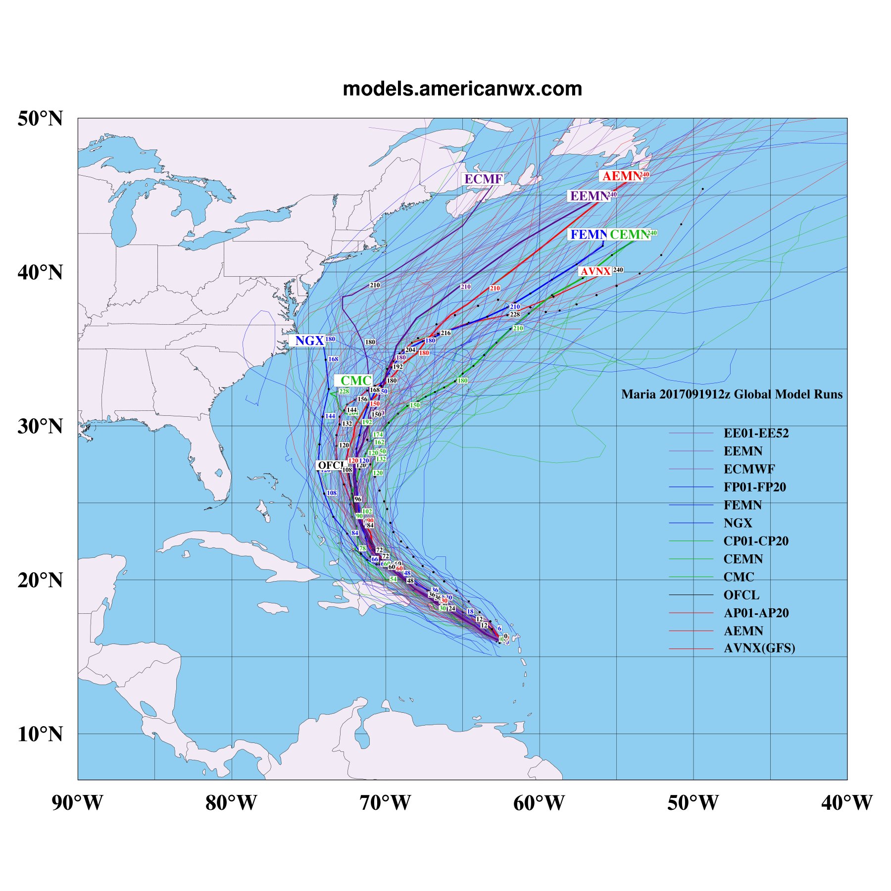
GFS is way west at 18z gonna be close to a hit
Brent
Member

Brent
Member

NorthBamaWeather
Member
- Joined
- Dec 3, 2016
- Messages
- 92
- Reaction score
- 78
Don't forget with both Harvey and Irma models trended West as much as 200 miles within 1-4 days of landfall. Models have under estimated the High Pressure since Hurricane Season started. With that said, they have been decent at beginning of track till the High came into play. Food for thought.
Webberweather53
Meteorologist
Latest extrapolated MSLP continues to tank in the center of Maria... 909 hPa w/ 20 kt wind (equates to ~906-907 mb). Dropsonde will probably find something closer to 910 hPa.

pcbjr
Member
Don't forget what the DR and Haiti can do to a storm, and where it goes and what it does or might do ... not a forecast or even a suggestion ... just a reminder
Webberweather53
Meteorologist
SFMR was 152 knots this pass through Maria's NW quad. Probably about 155 knots (180 mph) ish at the moment
Brent
Member
Closer than Jose

Gfs has more interaction with the baggy trough over the gomex and washes Jose out which allows tune NE ridge to bridge with the atlantic ridge. It also had a much stronger/farther west ridge in the atlantic. There are a couple of scenarios that would favor Maria getting well west. As has been the theme it all depends on Jose
Sent from my SM-G955U using Tapatalk
Sent from my SM-G955U using Tapatalk
I really don't know how people don't remember the west trend with Hurricanes as they get closer, The WAR have been unestimated all summer by the models.
- Joined
- Sep 4, 2017
- Messages
- 216
- Reaction score
- 260
Can we have a cringe button next to like, Yikes!SFMR was 152 knots this pass through Maria's NW quad. Probably about 155 knots (180 mph) ish at the moment

Webberweather53
Meteorologist
Recon finds the pressure in Maria still falling, now down to about 909 hPa given the 910mb surface reading w/ 14 kt wind. Places Maria inside the top 10 all time for lowest MSLP for any Atlantic Tropical Cyclone.
History in the making...

History in the making...
BHS1975
Member
Recon finds the pressure in Maria still falling, now down to about 909 hPa given the 910mb surface reading w/ 14 kt wind. Places Maria inside the top 10 all time for lowest MSLP for any Atlantic Tropical Cyclone.
History in the making...
View attachment 1314
This season makes 2005 look weak.
Sent from my iPhone using Tapatalk
Webberweather53
Meteorologist
This season makes 2005 look weak.
Sent from my iPhone using Tapatalk
Up to this point they're fairly comparable, but 2005 did not take its foot off the gas deep into October and November... Idk if we'll be able to do that this year
Off Topic of Maria but look at this in the Southern Carribean!! Ummm

Last edited:
Yeah far from a done deal...last 4 GFS runsGfs has more interaction with the baggy trough over the gomex and washes Jose out which allows tune NE ridge to bridge with the atlantic ridge. It also had a much stronger/farther west ridge in the atlantic. There are a couple of scenarios that would favor Maria getting well west. As has been the theme it all depends on Jose
Sent from my SM-G955U using Tapatalk

Sent from my SM-G920V using Tapatalk
Brent
Member
Reports just received from an Air Force Reserve Hurricane Hunter
aircraft indicate that the maximum sustained winds have increased
to 175 mph (280 km/h). The estimated minimum pressure based on
data from the aircraft is 909 mb (26.84).
aircraft indicate that the maximum sustained winds have increased
to 175 mph (280 km/h). The estimated minimum pressure based on
data from the aircraft is 909 mb (26.84).
NHC just updated to thatReports just received from an Air Force Reserve Hurricane Hunter
aircraft indicate that the maximum sustained winds have increased
to 175 mph (280 km/h). The estimated minimum pressure based on
data from the aircraft is 909 mb (26.84).
7:00 PM AST Tue Sep 19
Location: 16.9°N 64.1°W
Moving: WNW at 10 mph
Min pressure: 909 mb
Max sustained: 175 mph
Stormlover
Member
10th lowest Atlantic hurricane by pressure.
OMG.... and 3.5 million people in PR directly in her path

ForsythSnow
Moderator
Drop just found 193 mph at the surface!
pcbjr
Member
when is the "s" word allowed?Drop just found 193 mph at the surface!
ForsythSnow
Moderator

This is going to be horrendous for PR. I went in 1998 a few months after Georges and still had to switch hotels because they were still doing repairs. El Yunque had a ton of tree damage, and entire species of birds were wiped out. I can't imagine what this will do
pcbjr
Member
I don't want to come off as some sort of saint or pontiff --- of which I am assuredly neither, but somehow please take a minute and ask in whatever way you do and feel best doing that God has mercy ...This is going to be horrendous for PR. I went in 1998 a few months after Georges and still had to switch hotels because they were still doing repairs. El Yunque had a ton of tree damage, and entire species of birds were wiped out. I can't imagine what this will do
I was thinking it wouldn't get down below 900mb yesterday. Webber, do you happen to have the maximum potential strength for the area it's in?
Now...when is the "s" word allowed?
pcbjr
Member
sheetzzzzNow...