• Hello, please take a minute to check out our awesome content, contributed by the wonderful members of our community. We hope you'll add your own thoughts and opinions by making a free account!

Tropical Major Hurricane Helene

Status
Not open for further replies.
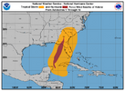
...HELENE PRODUCING DAMAGING GUSTY WINDS AND LIFE-THREATENING FLOODING OVER PORTIONS OF THE SOUTHEAST AND SOUTHERN APPALACHIANS... ...FLASH FLOOD EMERGENCY IN EFFECT FOR METROPOLITAN ATLANTA...

8:00 AM EDT Fri Sep 27
Location: 34.2°N 83.0°W
Moving: N at 30 mph
Min pressure: 972 mb
Max sustained: 60 mph
 
WRAL in house model showing 40-50 mph gust across central NC, mostly with that squall line later but they stated this is due to center being further east than anticipated. Are we the only one's that looked at the globals and saw this coming? Lol
 
The eyewall is no joke. I made it the entire storm with power and as soon as we were on the last leg the power goes out about 15-20 minutes ago. The wind is blaring right now and. It’s been raining for about 36 hours straight at least but for the last 6 hours we have been getting hit with constant bands even before the eye wall got here
 
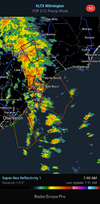
For those in eastern SC, central NC and eastern NC this will be our story in this. Thisis the band that brings us our tornado threat View attachment 152151
Take this band seriously. Woke me straight up around 530am. One of those cells produced a mesovortex spin in which the winds were easily gusting to hurricane force. Extremely wild watching the intense blinding rain spin around in front of the large parking lights. Hadn't been that nervous since Dorian
 
WRAL in house model showing 40-50 mph gust across central NC, mostly with that squall line later but they stated this is due to center being further east than anticipated. Are we the only one's that looked at the globals and saw this coming? Lol
I mean... it's basic common sense 😂
 
Take this band seriously. Woke me straight up around 530am. One of those cells produced a mesovortex spin in which the winds were easily gusting to hurricane force. Extremely wild watching the intense blinding rain spin around in front of the large parking lights. Hadn't been that nervous since Dorian
So I guess this is literally the calm before the storm here.
 
Take this band seriously. Woke me straight up around 530am. One of those cells produced a mesovortex spin in which the winds were easily gusting to hurricane force. Extremely wild watching the intense blinding rain spin around in front of the large parking lights. Hadn't been that nervous since Dorian
That happened to me with PTC 8 had a mesocyclone go by that crabkedmy winds into the upper 50s
 
Hey weather family
Been here in Pineville NC trying to run dialysis pts if power stays on can I get updated on the status of this storm? Any ideas of timeline for our area?
Thanks and all stay safe
 
Status
Not open for further replies.
Back
Top