• Hello, please take a minute to check out our awesome content, contributed by the wonderful members of our community. We hope you'll add your own thoughts and opinions by making a free account!

Tropical Major Hurricane Helene

I've already recorded well over five inches of rain, I actually think that the number of trees down in Middle/South Georgia tonight will be astronomical in terms of coverage due to the combination of wind speed/moisture soaked ground. I told someone earlier that I think that this will have the potential to do more damage (maybe not as intense) over a bigger geographic area than Michael.
 
I've already recorded well over five inches of rain, I actually think that the number of trees down in Middle/South Georgia tonight will be astronomical in terms of coverage due to the combination of wind speed/moisture soaked ground. I told someone earlier that I think that this will have the potential to do more damage (maybe not as intense) over a bigger geographic area than Michael.
You are in a really bad location.
 
Going to be a really different experience depending on what side of the center you are on, west side still not showing much of anything with surface winds barely over 50-60 mph even right on the center....versus the east side where surface winds at cane force 150 miles from the center.....there is still 4-5 hrs for her to get that sorted out some but it seems unlikely outside of a tight core of winds around the western eyewall is she can get it built in time.

1727386785860.png
 
Interesting dynamic, IR is probably the best it has looked but the eyewall on radar has degraded tremendously on the western side over the past hour. That said that isn’t unexpected in hurricanes under these circumstances.

That said that eastern wall is a beast.
 
Most of the mesoscale models continue to show a track to the north east corner of Georgia? Are they not trustworthy for tropical systems? The nhc track is much different.
 
Interesting dynamic, IR is probably the best it has looked but the eyewall on radar has degraded tremendously on the western side over the past hour. That said that isn’t unexpected in hurricanes under these circumstances.

That said that eastern wall is a beast.
Wherever that eastern eyewall comes ashore will likely see a 20ft plus storm surge. Hopefully it’s in as little a populated area as possible
 
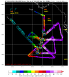
215230 2754N 08422W 7527 02045 9467 +227 +145 204039 042 /// /// 03
215300 2754N 08419W 7519 02057 9462 +239 +130 205044 045 /// /// 03
215330 2754N 08417W 7517 02061 9466 +237 +139 204050 053 /// /// 03
215400 2753N 08414W 7523 02063 9478 +227 +157 201063 071 /// /// 03
215430 2753N 08412W 7522 02078 9510 +199 +171 199077 082 /// /// 03
215500 2753N 08409W 7521 02097 9537 +186 +185 198088 089 /// /// 05
215530 2753N 08407W 7512 02125 9556 +184 +180 200099 107 /// /// 03
215600 2753N 08404W 7512 02138 9582 +173 +187 198124 128 /// /// 05
215630 2753N 08402W 7529 02135 9603 +171 +182 195130 134 /// /// 05
215700 2753N 08400W 7497 02186 9627 +161 +188 188134 136 /// /// 05
215730 2753N 08358W 7523 02178 9648 +159 +183 186134 136 /// /// 05
215800 2753N 08356W 7522 02206 9676 +163 +182 185126 130 /// /// 05
215830 2753N 08354W 7524 02225 9705 +156 +175 184118 124 /// /// 05
215900 2753N 08351W 7513 02254 9717 +162 +175 184116 117 /// /// 05
215930 2753N 08349W 7523 02258 9726 +169 +177 185110 115 /// /// 05
220000 2753N 08347W 7516 02273 9741 +164 +177 187108 108 /// /// 05
220030 2753N 08345W 7518 02286 9754 +164 +174 184104 108 /// /// 05
220100 2753N 08343W 7516 02295 9763 +165 +168 183099 102 /// /// 05
220130 2753N 08341W 7519 02299 9775 +162 +168 184096 097 /// /// 05
220200 2753N 08339W 7520 02305 9779 +165 +174 184095 096 /// /// 05
136 kt flight-level winds. The SFMR sensor is not working.
 
Back
Top