• Hello, please take a minute to check out our awesome content, contributed by the wonderful members of our community. We hope you'll add your own thoughts and opinions by making a free account!

Tropical Major Hurricane Grace

If Grace slows down as forecast--which is obviously not a sure
thing--environmental conditions should be conducive to allow for
some strengthening before the system reaches the Greater Antilles.
The southward adjustment in the official forecast now takes Grace
over the Greater Antilles for a longer period of time, and the
official intensity forecast is therefore lowered beyond 48 hours.
This is a middle-of-the-road solution, and actually lower than most
of the intensity guidance. If the forecast track shifts north or
south, the system could strengthen further over water.
Alternatively, Grace could go the way of Fred and dissipate before
the end of the 5-day period.
 
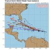
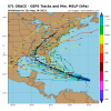
I think it’s easy to see the what to look for here .. The stronger the storm is the more north it will go so a benchmark is if it scrapes the northern part of Puerto Rico it probably means it’s going to take that northern track and then if it’s weaker it’ll go and just run through Puerto Rico and then Hispaniola and get shredded by those mountains and possibly return into the golf but I think we’re looking at a scenario that is either like the HMON or the HWRF
 
Also, watch Invest 96L for the possibility that it does something not well modeled that then disrupts the steering flow enough to cause a significant deviation in Grace’s track vs modeling since 96L isn’t in a vacuum.
 
Also, watch Invest 96L for the possibility that it does something not well modeled that then disrupts the steering flow enough to cause a significant deviation in Grace’s track vs modeling since 96L isn’t in a vacuum.

I was thinking maybe 96L buckles the ridge a bit
 
BULLETIN
Tropical Storm Grace Advisory Number 7
NWS National Hurricane Center Miami FL AL072021
1100 PM AST Sat Aug 14 2021

...POORLY ORGANIZED GRACE NOW MOVING A BIT SLOWER...
...HEAVY RAINFALL ACROSS THE LESSER AND GREATER ANTILLES REMAINS A
PRIMARY THREAT OVER THE NEXT FEW DAYS...


SUMMARY OF 1100 PM AST...0300 UTC...INFORMATION
-----------------------------------------------
LOCATION...16.8N 62.4W
ABOUT 170 MI...275 KM ESE OF ST. CROIX
ABOUT 265 MI...430 KM ESE OF SAN JUAN PUERTO RICO
MAXIMUM SUSTAINED WINDS...40 MPH...65 KM/H
PRESENT MOVEMENT...WNW OR 285 DEGREES AT 20 MPH...31 KM/H
MINIMUM CENTRAL PRESSURE...1010 MB...29.83 INCHES
Grace starting to slow down.
Graphic:
025751_5day_cone_with_line_and_wind.png
 
HWRF smashes Puerto Rico but then is able to make it north of Hispaniola .. that’s the key difference … if it can make it north of that island of shredders then we have a problem on our hands for Florida .. if it goes through the ringer then this thing is getting torn up and spit out into the Gulf which it will need a long time to recover
 
Back
Top