-
Hello, please take a minute to check out our awesome content, contributed by the wonderful members of our community. We hope you'll add your own thoughts and opinions by making a free account!
You are using an out of date browser. It may not display this or other websites correctly.
You should upgrade or use an alternative browser.
You should upgrade or use an alternative browser.
Wintry Machine Learning Mauler 1/30-2/1
- Thread starter SD
- Start date
iGRXY
Member
AIGFS looks unchanged thru 72
NBAcentel
Member
AIGFS is a Charlotte to GSP nuke with the upper level low 
iGRXY
Member

Better and better each run
iGRXY
Member
AIGFS is 12-14"+ from GSP to CLT and the central piedmont this run. 4-8" in NE Georgia into the western upstate and mountains
wow
Member
GFS still likes west

NBAcentel
Member
Final
iGRXY
Member
This GFS run is going to be better than 12z lol
wow
Member
Tilt still trending less positive.. notice height rising ahead of it.. PNA ridge trending taller..

CNCsnwfan1210
Member
Tilt still trending less positive.. PNA ridge trending taller..
View attachment 190148
This one might be good
Sent from my iPhone using Tapatalk
oh yea

broken025
Member
Should be another big dog here
iGRXY
Member
 Nuke incoming
SnowNiner
Member
Tilt still trending less positive.. notice height rising ahead of it.. PNA ridge trending taller..
View attachment 190148
it's got @SD thumb ridge poking back east a bit too.
AIGFS has got to be better than normal bad GFS right? Right? Anybody? Bueller?
wow
Member
Coast is rain. This is a bomb.

packfan98
Moderator


Eyeballing 6 hour qpf and temps Saturday AI GFS throws maybe a up to a Inch of snow as far West as Bartow/Paulding if ratios are decentit's got @SD thumb ridge poking back east a bit too.
AIGFS has got to be better than normal bad GFS right? Right? Anybody? Bueller?
NBAcentel
Member
You can see the strong mesolow this GFS run as well, it’s where there storm truly begins and starts to crank, as it induces a period of FGEN right along the front 

broken025
Member
This is going to be absurd. NC still getting bombed here. Probably another 10 inches to come for some.
Is it suspect the GFS can pull this off with the upper low...that seems like Mahomes magic type play against the Bills...
Its flat as a pancake at 72 hours and then 24 hours later full blown bomb...

Its flat as a pancake at 72 hours and then 24 hours later full blown bomb...
znel52
Member
Monster on the GFS. Starts the SENC coast out as rain again but changes over to all snow.
Sent from my Pixel 8 Pro using Tapatalk
Sent from my Pixel 8 Pro using Tapatalk
SnowNiner
Member
You can see the strong mesolow this GFS run as well, it’s where there storm truly begins and starts to crank, as it induces a period of FGEN right along the front View attachment 190154View attachment 190155
IIRC my favorite storm Feb 2004 had a meso low in a similar spot that led to further snowfall overnight in the CLT area. Don't know the specifics though. Also it can't be a bad thing that AIFS also had one in a similar location the last run.
Maybe we just completely lose the coastal but can keep that?
wow
Member
Complete phase with that southern s/w rolling through TX..Is it suspect the GFS can pull this off with the upper low...that seems like Mahomes magic type play against the Bills...
Its flat as a pancake at 72 hours and then 24 hours later full blown bomb...
View attachment 190157
broken025
Member
Looks legit. Roxboro gets 30.

packfan98
Moderator
Supposed to start in exactly 3 days…
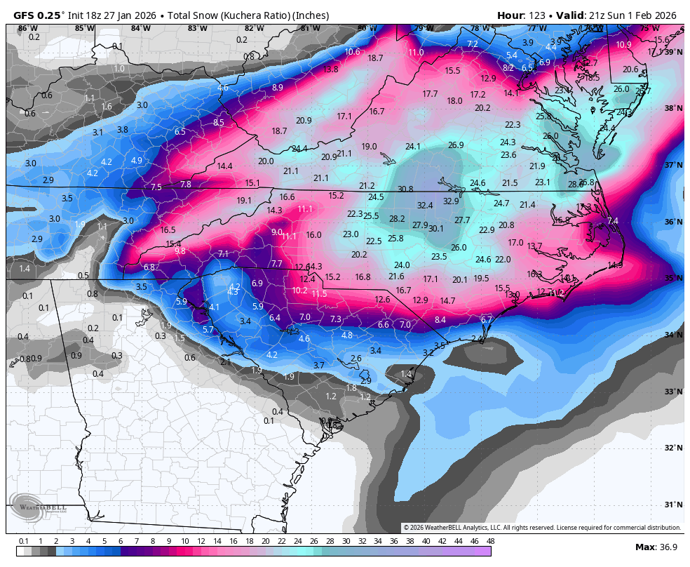


Pushing blizzard criteria in the Coastal Plain


Ok this is insane. Goofy isn’t putting this out in fantasy land. This is something that’s literally inside 80 hours before it would start.
wow
Member
MA/NE are getting close now. Blizzard of '96, Part II ?
Only problem is it was the EURO that was honking for that one.. the GFS (then known at the AVN/MRF) was the whiffer!
Only problem is it was the EURO that was honking for that one.. the GFS (then known at the AVN/MRF) was the whiffer!
broken025
Member
Should be some wild NAM runs starting tomorrow
BrickTamland
Member
Crazy GFS run. Last Canadian was a crush job still, but cut the totals in half. Meanwhile, GFS just adds even more compared to the last run. UK and ICON are complete wiffs. Euro has a decent one for NC. Models are still all over the place today and we're 3 to 4 days out.
Just a quick observation. I checked my NWS graph forecast and right now they ready have wind gusts 20-25mph during the day on Saturday. IF a coastal gets going, you can expect those to be higher. Even if it’s short of blizzard criteria, there could a good bit of blowing and drifting

Tail end of the arctic trough isn't reaching as far north as it once was. I imagine this is a better trend regarding tilt, but that also will depend on its rotation into a neutral/neg tilt once it reaches into the Eastern U.S.
It could be due to stronger ridging starting to become apparent into Hudson Bay, but that's just my opinion.
JHS
Member
That's the fastest temp drop I have had with winter precip ever. We went from the low 40's down into the upper 20's in about 15 minutes. It started as rain, but VERY quickly went to snow. We had thunder with this too.Here’s what the leeside trough can do. There are winners and losers. Charlotte usually wins. Here’s my favorite one @rburrel2 although it’s probably not yours lolView attachment 190160View attachment 190159
Excellent chance the GFS leaves us standing at the altar looking for our bride, but regardless, any solution that drops a teardrop to the west like that is a good thing. Don’t want all models trending east or flat and terrible
Last edited:
wow
Member
Need to also pay attention to the strength of the southern s/w which sets up the big phase. That will determine how quickly the the trough axis rotates. GFS is the goal post.

GEFS continues to push that trough of interest further west as well as strengthening its base.
Another small thing to note is that there's now small (but apparent) ridging between the bulb off of Newfoundland and the one in the Great Lakes. Not sure if it's actively ridging or just due to the separation causing that visual effect.