ForsythSnow
Moderator
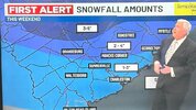
I still bet the FGEN isn't even fully factored in unless theres a reason it's not showing. Maybe that's the explanation for a W trend too is we aren't even seeing a factor show.This storm is HELL for Atlanta forecasters. Like what am I supposed to make of this??
View attachment 191394View attachment 191395