-
Hello, please take a minute to check out our awesome content, contributed by the wonderful members of our community. We hope you'll add your own thoughts and opinions by making a free account!
You are using an out of date browser. It may not display this or other websites correctly.
You should upgrade or use an alternative browser.
You should upgrade or use an alternative browser.
Wintry Machine Learning Mauler 1/30-2/1
- Thread starter SD
- Start date
BrickTamland
Member
GeorgiaGirl
Member
Last of the snow shower activity passed me by by about 10 PM. I didn't go outside to check it out, but I know based on streetlights/using the house light that the road out front finally quit and at least had a light dusting.
Several local reports of heavier snow to my west and I believe southwest.
Several local reports of heavier snow to my west and I believe southwest.
Sctvman
Member
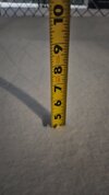
3+!
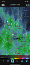
It's coming down much harder than returns would indicate here in northwestern Horry county. I shoveled right at an hour ago and that was easily another inch. I'll get another tape measure check at 1130 or midnight.
Thrasher Fan
Member
Winds still ripping out there. Just had a gust to 51 mph. Sustained 30 mph.
Shaggy
Member
We are also making up for lost time. Won't reach my WSW totals I don't think but the hrrr is insistent on 8-10 here overnight.Visibility is less than .33 can't see the lights at the entrance to the neighborhood. Half inch so far. So cold
Picking up for me in starland
Really coming down here, near the heaviest yet! Down to 26. Now sticking on some of the sidewalk. Probably now dangerous to drive. I’ve been home and am not going anywhere at least til tomorrow afternoon.
JimBobs
Member
The current nighttime snowfall reminds me of the 2000 storm. That was the Raleigh Carolina Crusher. CLT Airport recorded only 4-5 inches however. I lived in extreme East Mecklenburg County and a finger of the snow parked over us in Matthews. That night the snow just refused to wrap up. It just kept flurrying and moderately snowing. Eventually measured 17 inches, the only time I have ever felt I was in the perfect location. Banter, sorry.
You know as much as I love seeing a good daytime snowfall pile up like we did today, there is nothing quite pristine and peaceful as watching it snow at night.
Yeah it’s really covered my street in the last 30-1hr. Really nice we’re getting this last band, think we will end up with about the same as last year.Really coming down here, near the heaviest yet! Now sticking on some of the sidewalk. Probably now dangerous to drive.

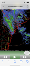
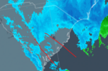
This is an incredible radar image. Look at the convective snow and then supercellular thunderstorms on the warm side of the low. Just unreal. Looks like that’s 2-3” am hour for a lot of eastern NC and down the coast to SC
Sent from my iPhone using Tapatalk
Yep I remember. Was living in NoDa then and had 9” there. The amounts increased quickly S of me. Think Rock Hill had 20” during that storm.?The current nighttime snowfall reminds me of the 2000 storm. That was the Raleigh Carolina Crusher. CLT Airport recorded only 4-5 inches however. I lived in extreme East Mecklenburg County and a finger of the snow parked over us in Matthews. That night the snow just refused to wrap up. It just kept flurrying and moderately snowing. Eventually measured 17 inches, the only time I have ever felt I was in the perfect location. Banter, sorry.
Btownheel
Member
I thought it was over with here before dark. It had quit. Dadgum, if it didn't start back up about three hours ago, and it's still snowing. 14 degrees. I'll have to do a new measurement in the morning.
Dude, you’re a magnet. Have been since I first started in the forums 15 years ago. It’s uncanny!
Sent from my iPhone using Tapatalk
Still snowing at a good clip in between Clayton and Wilson’s Mills. Measured the depth on the hood of my truck again and just crossed 7 inches… I thought after being dry slotted most of the day we’d have a hard time hitting 3-4, but this has just been incredible.
Nearly 3” in Port Royal while James Island might have 1/4”. Wild
Y'all might get the band rotating SE now in the Charleston area.
Epic right now
Lordhelmit
Member
It's one of the most peaceful quiets. It's what I love about a snowfall.You know as much as I love seeing a good daytime snowfall pile up like we did today, there is nothing quite pristine and peaceful as watching it snow at night.
We are also making up for lost time. Won't reach my WSW totals I don't think but the hrrr is insistent on 8-10 here overnight.
The band is basically stationary NW to SE so I'm starting to wonder if the HRRR is going to turn out to be right. We still have a high end chance from the NWS of 10+.
Stormsfury
Member
That patch in Goose Creek is indeed light snowing. Just flapping in the wind but better than pixie dust.Y'all might get the band rotating SE now in the Charleston area.
Edit, Charleston WFO states we still sit within an area that deformation bands could pop for a bit so if something can get going, maybe just maybe, we can score a little bit more.
WxBlue
Meteorologist
I just got back from winter photography around my town. My hands frozed in sub-zero wind chills and roads were not plowed at all. But my god, I got beautiful pictures of my town!
Shaggy
Member
@Avalanche @SENC @Disco_Lemonade. Things really ramping up last 30 minutes. We snow like.this for a few hours we will get to 5 inches I believe
Snow seems to be picking up here big time in the last few minutes.
Shaggy
Member
Rgem just ran us 12 inches here at 0zThe band is basically stationary NW to SE so I'm starting to wonder if the HRRR is going to turn out to be right. We still have a high end chance from the NWS of 10+.
disassociated_vort
Member
Stormsfury
Member
Lot of stuff currently not being picked up on radar well due to the low dendritic growth zone above the deck.
Absolutely beautiful outside. Looking at radar, and maybe more than 6" on the table. Big big win for what we went through earlier today.
Puking!
Rgem just ran us 12 inches here at 0z
Yep. The counties either side of the state line (Dillon, Horry, Robeson, Columbus, and Brunswick) are sitting on the jackpot right now.
wow
Member
Having a Jesus glory moment ?Epic right now
JimBobs
Member
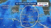
Looking at the big picture radar, it now appears the coastal low is pushing and rotating moisture almost all the way back to the CLT area. I hadn't even bothered to look at that.
Downeastnc
Member
Winds gusting to 35 easy now...snow ripping again radar doesn't suggest we stop anytime soon..
Gotta be the heaviest snow of the storm so far now!
WxBlue
Meteorologist
If the eastern bands keep coming at us for multiple hours, 6+ inches is absolutely viable for us. I was bummed earlier at the late onset but oh man we’ve been making up for it the past few hours!Absolutely beautiful outside. Looking at radar, and maybe more than 6" on the table. Big big win for what we went through earlier today.
CNCsnwfan1210
Member
Almost 10:45pm and 4 inches of snow accumulation in SW Wilson county with heavy snow still falling. A pic of some narly drift action.

Sent from my iPhone using Tapatalk

Sent from my iPhone using Tapatalk

