• Hello, please take a minute to check out our awesome content, contributed by the wonderful members of our community. We hope you'll add your own thoughts and opinions by making a free account!

Wintry King Kong Winter Storm Potential Feb 13th-16th

371
NWUS54 KFWD 150610
LSRFWD

PRELIMINARY LOCAL STORM REPORT...CORRECTED
NATIONAL WEATHER SERVICE FORT WORTH TX
1210 AM CST MON FEB 15 2021

.TIME... ...EVENT... ...CITY LOCATION... ...LAT.LON

.DATE... ....MAG.... ..COUNTY LOCATION..ST.. ...SOURCE.


..REMARKS..

1200 AM SNOW 3 NE EULESS 32.88N 97.04W
02/15/2021 M4.0 INCH TARRANT TX ASOS

4 INCHES OF SNOW MEASURED BY D/FW AIRPORT
SNOW OBSERVERS.
----------------


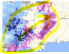
And it is still snowing lightly. The coldest heavy snow in DFW recorded history. And the heaviest cold snow by a good margin. Also, the heaviest snowstorm since 2/2010.
 
Last edited:
Few people are as wrong as often as Clay Travis is so it sounds like the people of Nashville better get out the beach wear and sunscreen.
He wasn’t lying as it looked like shards of glass falling out of the sky about 30 minutes ago Here. Temps at 23.5 degrees. Going to be interesting to see if the snow is cut back here as much as models have shown tonight. I don’t think I have to worry about zr as much as just sleet.
 
mcd0085.gif
Mesoscale Discussion 0085
NWS Storm Prediction Center Norman OK
0309 AM CST Mon Feb 15 2021

Areas affected...parts of southern LA...southern into eastern
MS...northwest AL

Concerning...Freezing rain

Valid 150909Z - 151515Z

SUMMARY...Freezing rain rates 0.05-0.20 inch per 3 hours are
possible through 9am CST.

DISCUSSION...Radar mosaic shows a relatively small precipitation
shield moving northeast from southeast LA towards southern MS as of
3am CST. Surface conditions show temperatures ranging from near
freezing in southern LA to the middle 20s over central MS. Baton
Rouge recently observed over a tenth of liquid-equivalent
precipitation in the past hour (09z observation).

Large-scale ascent, associated with the eastward-migrating shortwave
trough over the southern Great Plains, will steadily increase early
this morning across the lower MS Valley. The leading edge of
stronger ascent is already implied in water-vapor imagery with
convection over southwest LA. The 06z NAM model indicated 3-hourly
precipitation totals generally in the 0.05-0.15 inch range but had
locally higher amounts. Forecast soundings from southern LA
northeastward show a sub-freezing layer beneath a layer near 850 mb
around 5-8 C. The profile will support freezing rain as the primary
precipitation type early this morning. Sleet may intermittently mix
with freezing rain, especially in the northwest quarter of the
discussion area where the depth of cold air is more favorable for
sleet.

..Smith.. 02/15/2021
 
ICE STORM WARNING!1613384015024.pngtHIS IS VERY SERIOUS.
Ice Storm Warning
URGENT - WINTER WEATHER MESSAGE
National Weather Service Huntsville AL
402 AM CST Mon Feb 15 2021

ALZ001>007-016-160015-
/O.UPG.KHUN.WS.W.0001.000000T0000Z-210216T1200Z/
/O.NEW.KHUN.IS.W.0001.210215T1002Z-210216T1200Z/
Lauderdale-Colbert-Franklin AL-Lawrence-Limestone-Madison-Morgan-
Cullman-
Including the cities of Florence, Muscle Shoals, Sheffield,
Tuscumbia, Russellville, Red Bay, Moulton, Town Creek, Athens,
Huntsville, Decatur, and Cullman
402 AM CST Mon Feb 15 2021

...ICE STORM WARNING IN EFFECT UNTIL 6 AM CST TUESDAY...

* WHAT...Significant icing. Ice accumulations up to one half
inch. Snow and sleet accumulations of up to one inch.

* WHERE...Lauderdale, Colbert, Franklin AL, Lawrence, Limestone,
Madison, Morgan and Cullman counties.

* WHEN...Until 6 AM CST Tuesday.

* IMPACTS...Power outages and tree damage are likely due to the
ice. Travel could be nearly impossible, especially by late this
morning and through much of the day. These hazardous travels
conditions will impact the morning and evening commute.

* ADDITIONAL DETAILS...Power outages will be likely due to the
expected ice accumulations, which in some rural areas could last
for a few days. The combination of bitter cold temperatures
tonight into Tuesday will make conditions particularly
hazardous for those that do lose power. Residents should be
prepared and have an emergency supply kit ready in event of a
long duration power outage. Travel conditions will be very slow
to improve on Tuesday into Wednesday, even after the
precipitation ends.

PRECAUTIONARY/PREPAREDNESS ACTIONS...

Travel is strongly discouraged. If you must travel, keep an extra
flashlight, food and water in your vehicle in case of an
emergency. Prepare for possible power outages.
 
FIRST TIME EVER FOR ICE STORM WARNING FOR HUNTSVILLE COVERAGE AREA SINCE THIS HAZARD STARTED BEING USED
1613384609738.png
1613385002845.png
 
Last edited:
Back
Top