Yes, for everyone but Jonesville, which, of course, will remain a scorched wasteland of drought and utter misery, engulfed in the undying flames of Hades for all eternity.Meant to add I am at the beach next week. Expect this to turn into a 17 contour upper low with a 1046 wedge high, record low maxes and daily rainfall records
-
Hello, please take a minute to check out our awesome content, contributed by the wonderful members of our community. We hope you'll add your own thoughts and opinions by making a free account!
You are using an out of date browser. It may not display this or other websites correctly.
You should upgrade or use an alternative browser.
You should upgrade or use an alternative browser.
Pattern June Presented by: Heat and Humidity
- Thread starter SD
- Start date
blueheronNC
Member
Rain hole dead center on Raleigh for next 10 days. Welcome to summer.View attachment 43253
Even if this were to verify (and this is just a 10 day period on a highly unreliable op GFS), RDU is now about the wettest in the country with +100-120 mm anomaly (+4-5”) and wetter than 99% of June 23rds on record!


Edit: There’s still no long lasting intense SE heat in sight. I give the very wet soils in much of the SE credit for this.
Webberweather53
Meteorologist
blueheronNC
Member
Even if this were to verify (and this is just a 10 day period on a highly unreliable op GFS), RDU is now about the wettest in the country with +100-120 mm anomaly (+4-5”) and wetter than 99% of June 23rds on record!
Anomalies aside, 23.76” at RDU with half the year in the books isn’t that impressive in absolute terms. Still one of the driest spots in NC for the year so far with many parts of the Southeast already double that.

Unless things get crazy next week I will likely finish May and June basically average on precip.Anomalies aside, 23.76” at RDU with half the year in the books isn’t that impressive in absolute terms. Still one of the driest spots in NC for the year so far with many parts of the Southeast already double that.
Webberweather53
Meteorologist
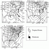
As much as I'll enjoy the rain from this, this is definitely the kind of pattern you do not wanna see during the middle of the hurricane season. A retrograding cut upper low underneath a big SE Canada ridge is the classic recipe for getting a hurricane to strike the SE US.
View attachment 43259
One of the most classic examples of a retrograding cut off upper low over allowing a hurricane to pinwheel into the SE US.
Hugo (1989)

smast16
Member
Fran had one over TN tooOne of the most classic examples of a retrograding cut off upper low over allowing a hurricane to pinwheel into the SE US.
Hugo (1989)
Webberweather53
Meteorologist
Yeah you can also add Isabel to that listFran had one over TN too
Anomalies aside, 23.76” at RDU with half the year in the books isn’t that impressive in absolute terms. Still one of the driest spots in NC for the year so far with many parts of the Southeast already double that.
View attachment 43260
With normal YTD near 20”, the anomaly is almost +4”. Yes, nothing extreme and not nearly as wet as other locations, but flooding is a bigger risk than drought as of now. With still no heatwave in sight, there’s no reason to be worried about drought anytime soon.
NAM has storms after midnight up here into Thursday morning for many in NC
fun as in cloud cooler temp and heavier shower for Wilkes.
smast16
Member
Why does it look like the east coast low is trying to tickle the western low...This gfs run should be fun for late next week. Both lows on each side of the omega block mingling together under the ridge centerView attachment 43275View attachment 43276
Why does it look like the east coast low is trying to tickle the western low...
Every heard of an MCV? That is the precursor pattern.
Haha I see exactly what you are sayingWhy does it look like the east coast low is trying to tickle the western low...
HuhWhy does it look like the east coast low is trying to tickle the western low...
BHS1975
Member
As much as I'll enjoy the rain from this, this is definitely the kind of pattern you do not wanna see during the middle of the hurricane season. A retrograding cut upper low underneath a big SE Canada ridge is the classic recipe for getting a hurricane to strike the SE US.
View attachment 43259
With the Arctic torching this type of pattern is more common.
Sent from my iPhone using Tapatalk


