99.3 on my Tempest
-
Hello, please take a minute to check out our awesome content, contributed by the wonderful members of our community. We hope you'll add your own thoughts and opinions by making a free account!
You are using an out of date browser. It may not display this or other websites correctly.
You should upgrade or use an alternative browser.
You should upgrade or use an alternative browser.
Pattern June Gloom
- Thread starter SD
- Start date
NoSnowATL
Member
Thank God for a sea breeze
Indeed RDU “cooled” to 98 at 3 PM. But as of the 2PM 99 reading, they had earlier already hit 100 for the high as of then.only 98 at RDU #cold
I saw that 100 as well. 98 must have been under a cloud at 2pm.Indeed RDU “cooled” to 98 at 3 PM. But as of the 2PM 99 reading, they had earlier already hit 100 for the high as of then.

Edit: 100 ties a record BTW.
91 here in the upstate. Plenty warm for me
It’s only around 90 down here in Miami.
86.5 at the house in Marietta.
I fly back to Atlanta this afternoon and Cancun tomorrow.
86.5 at the house in Marietta.
I fly back to Atlanta this afternoon and Cancun tomorrow.
96
There are thunderstorms just to the north of Raleigh and to the west of Wake County on radar. We will see if they increase in coverage and move enough to bring some relief from the heat, at least, to my residence near Lake Wheeler which is south of Raleigh.
Downeastnc
Member
Fair
99°F
37°C
99°F
37°C
| Humidity | 35% |
| Wind Speed | Vrbl 6 G 20 mph |
| Barometer | 29.85 in |
| Dewpoint | 66°F (19°C) |
| Visibility | 10.00 mi |
| Heat Index | 104°F (40°C) |
| Last update | 11 Jun 4:36 pm EDT |
I can hear the thunder rumbling but nothing on the ground yet. (sun is out)There are thunderstorms just to the north of Raleigh and to the west of Wake County on radar. We will see if they increase in coverage and move enough to bring some relief from the heat, at least, to my residence near Lake Wheeler which is south of Raleigh.
Might be a @FallsLake special.
Tsappfrog20
Member
I can hear the thunder rumbling but nothing on the ground yet. (sun is out)
Might be a @FallsLake special.
I heard it was a falls lake six forks special
Sent from my iPhone using Tapatalk
Sounds legit. At Lake Lynn/Leesville, I'm close enough to see and hear it. Even waive goodbye to it as she moves east..I heard it was a falls lake six forks special
Sent from my iPhone using Tapatalk
Here we ------- go again...

Cells is moving east south east.
could see heavy rain and possible svrs.
Cells is moving east south east.
could see heavy rain and possible svrs.
RDU hit a new record of 101! Thank the drought for that.I saw that 100 as well. 98 must have been under a cloud at 2pm.
Edit: 100 ties a record BTW.
Drizzle Snizzle
Member
94 here today but Dew Points are in the 60s so at least its fairly tolerable.There were nasty steamy highs of 92 at ATL and 94 at SAV.
Downeastnc
Member
Little meso trying to form on this cell...

And the yellow boxes and red lights are on!
WUUS52 KRAH 112245
SVRRAH
NCC069-101-127-183-112330-
/O.NEW.KRAH.SV.W.0034.260611T2245Z-260611T2330Z/
BULLETIN - IMMEDIATE BROADCAST REQUESTED
Severe Thunderstorm Warning
National Weather Service Raleigh NC
645 PM EDT Thu Jun 11 2026
The National Weather Service in Raleigh has issued a
* Severe Thunderstorm Warning for...
Southwestern Nash County in central North Carolina...
Northeastern Wake County in central North Carolina...
North central Johnston County in central North Carolina...
South central Franklin County in central North Carolina...
* Until 730 PM EDT.
* At 645 PM EDT, severe thunderstorms were located from 6 miles
south of Wake Forest to 7 miles northeast of Garner, moving east
at 15 mph.
HAZARD...60 mph wind gusts and quarter size hail.
SOURCE...Radar indicated.
IMPACT...Hail damage to vehicles is expected. Expect wind damage
to roofs, siding, and trees.
* Locations impacted include...
Raleigh, Wake Forest, Garner, Zebulon, Knightdale, Wendell,
Rolesville, Pilot, Emit, and Flowers.
This includes the following highways...
Interstate 540 between Mile Markers 18 and 24.
NC Highway 264 between Mile Markers 20 and 25.
PRECAUTIONARY/PREPAREDNESS ACTIONS...
For your protection move to an interior room on the lowest floor of a
building.
&&
LAT...LON 3594 7819 3562 7824 3570 7858 3596 7853
TIME...MOT...LOC 2245Z 290DEG 11KT 3588 7849 3575 7852
HAIL THREAT...RADAR INDICATED
MAX HAIL SIZE...1.00 IN
WIND THREAT...RADAR INDICATED
MAX WIND GUST...60 MPH
$$
Currently 73 degrees, full sun, brisk WNW breeze to 30 mph ! Lots of big limbs down, and whole trees down, and flooding from this mornings severe thunderstorms and some nickel sized hail!
GFS caving to the Euro continuing the drought. If it had been the Euro showing rain and the GFS dry, it would be the Euro doing the caving.
101 at the RDU sensor today 
It is truly hot as hell today regardless. I’m out walking the dog this evening and it’s pretty bad even now!
It is truly hot as hell today regardless. I’m out walking the dog this evening and it’s pretty bad even now!
Also, look what I ran into in Madison, WI back over Memorial Day weekend!!! 

very serious day especially in the north; enhanced risk for northern NC.

Carolinas may be spared from worst.Deep-layer flow/shear will be even weaker into parts of the southern Mid-Atlantic/Carolinas vicinity. However, very strong heating of a moist airmass will support potential for scattered thunderstorms with downburst potential, and eventual evolution into loosely organized clusters capable of damaging outflow winds this afternoon through at least the early evening hours.
Northern NC/Southern VA may be getting the worst of the weather. Prepare to lose power this afternoon.Scattered outflow-driven clusters may develop with time and move eastward, with an attendant threat of damaging wind and perhaps a few instances of marginally severe hail.
Already 85 imby. Historically before the rdu sensor broke reality we needed to be 90+ at 10 am to hit 100
90 at the econet site in chapel hill
88 Heat Index 92 at 10:00 Greensboro
WFFaithful
Member
HRRR looks sparse for afternoon storms
Its mixing us into the 50s not sure if that's the hrrr doing what it does or realityHRRR looks sparse for afternoon storms
honestly might be reality considering RDUs dew is already down to 65. could make the highs even hotter for that area today if yall do mix out.Its mixing us into the 50s not sure if that's the hrrr doing what it does or reality
Already 85 imby. Historically before the rdu sensor broke reality we needed to be 90+ at 10 am to hit 100
90 here
Rdu sensor is going to show off today
The 11AM 95 at RDU is along with Rocky Mount, NC, the hottest of ALL major reporting stations in the SE.Rdu sensor is going to show off today
24 hours ago, RDU was “only” 90 and Rocky Mt was 91.
raleigh 106 lock it inThe 11AM 95 at RDU is along with Rocky Mount, NC, the hottest of ALL major reporting stations in the SE.
24 hours ago, RDU was “only” 90 and Rocky Mt was 91.
raleigh 106 lock it in
It might but the CU field starting in the triad drifting SE might kill it.
91 IMBY. 96-97 out in the triangle
RDU sensor likely gets well over 100 today, already at 100 before 1pm
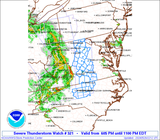
SEVERE THUNDERSTORM WATCH #321 HAS BEEN ISSUED UNTIL 9PM

Last edited: