KRDU in their discussion mentioned that next Tuesday would only have highs in the mid-upper eighties with lows in the mid-upper sixties. This will feel almost fall like compared to what we have been enduring lately. Our break seems to be short lived, however, with highs back into the nineties and lows back into the seventies on Wednesday and for the rest of the forecast period.
-
Hello, please take a minute to check out our awesome content, contributed by the wonderful members of our community. We hope you'll add your own thoughts and opinions by making a free account!
You are using an out of date browser. It may not display this or other websites correctly.
You should upgrade or use an alternative browser.
You should upgrade or use an alternative browser.
Pattern July Fry and Dry
- Thread starter SD
- Start date
Shaggy
Member
Wen flood
96 HI 120
96 HI 120
Last edited:
Brent
Member
I seriously wonder how people here survived the 1930s. What a horrible decade for hot weather
Still haven't beaten it
Still haven't beaten it
BHS1975
Member
Probably a lot dryer than now.I seriously wonder how people here survived the 1930s. What a horrible decade for hot weather
Still haven't beaten it
Shaggy
Member
They’re calling it the worst outflow boundary collision ever
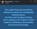
Highest chance appears to be 30% for tstorms until Monday, so hopefully the down time won't be too disruptive.maybe this was discussed already idkView attachment 173569
Yes I know but it's still like why
I don't know why it bothers me so much I sleep most of the day because of my work schedule right now anyway
If this has been an enjoyable summer compared to recent summers, then recent summers must have been very hot. Because Tulsa was actually around normal for temps in June and close to normal so far in July also.
95 has been the hottest this summer so far. The last time there hadn’t been 96+ as of today was way back in 2008! But then 2008 got very hot.
We may see a brief but minimal break:
From RAH:
".....................
Confidence is increasing that we`ll see the rare summertime
synoptic frontal passage Mon night or early Tue, as a relatively
cooler high with lower dewpoints in the 60s builds in from the Great
Lakes and St Lawrence Valley, while aloft, the longwave trough halts
briefly off the East Coast. This surface high is expected to slide E
and off the Northeast and Mid Atlantic coast by Thu while still
extending down through NC in an almost CAD-like configuration,
including lowering surface pressures along the Southeast coast as an
inverted trough develops. Highs should be mostly in the 80s Tue/Wed,
with relatively low humidity for this time of year. Once the high
pushes further out over the open NW Atlantic by Thu/Fri and
modifies, the heat is likely to return as the deep mid level
anticyclone builds from the central Miss Valley eastward across
NC/VA. ....................."
6z GFS dew points for midday Tuesday (0z was a little cooler/dryer into central NC):
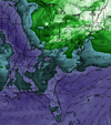
Sad to be looking forward to low 60s dew points. But you take any relief you can get...
From RAH:
".....................
Confidence is increasing that we`ll see the rare summertime
synoptic frontal passage Mon night or early Tue, as a relatively
cooler high with lower dewpoints in the 60s builds in from the Great
Lakes and St Lawrence Valley, while aloft, the longwave trough halts
briefly off the East Coast. This surface high is expected to slide E
and off the Northeast and Mid Atlantic coast by Thu while still
extending down through NC in an almost CAD-like configuration,
including lowering surface pressures along the Southeast coast as an
inverted trough develops. Highs should be mostly in the 80s Tue/Wed,
with relatively low humidity for this time of year. Once the high
pushes further out over the open NW Atlantic by Thu/Fri and
modifies, the heat is likely to return as the deep mid level
anticyclone builds from the central Miss Valley eastward across
NC/VA. ....................."
6z GFS dew points for midday Tuesday (0z was a little cooler/dryer into central NC):

Sad to be looking forward to low 60s dew points. But you take any relief you can get...
Storms coming up from myrtle beach were ringed with a rainbow. Pictures dont do it justice.
They were pretty nuts to be under here in central Horry. Picked up ~.5" with unbelievable lightning for what seemed like an hour and lots of low thunder from the stratiform for a long time after.
Downeastnc
Member
82/82 at 8:30 in the morning.....heat index will crack 100 anytime now. People that like this weather are nuts. Might get some storms today been blanked all week.
tennessee storm
Member
Sure beats the cold weather still82/82 at 8:30 in the morning.....heat index will crack 100 anytime now. People that like this weather are nuts. Might get some storms today been blanked all week.
Downeastnc
Member
Sure beats the cold weather still
Gonna have to disagree... I can go outside and do stuff when it gets cold and not die....this kind of heat is just miserable.
tennessee storm
Member
You can die in extreme cold weather also …. Depends how your body adapts to the elementsGonna have to disagree... I can go outside and do stuff when it gets cold and not die....this kind of heat is just miserable.
Brent
Member
82/82 at 8:30 in the morning.....heat index will crack 100 anytime now. People that like this weather are nuts. Might get some storms today been blanked all week.
Right the amount of people who have begged for this weather here for weeks is just mind boggling to me. The endless complaining on Facebook about the rain and how it was ruining their summer. I mean do they not remember when we had a 130 heat index a couple summers ago? Or the fact that August is usually our hottest month? Almost every heat record here is from August so we're not even close to being done probably beyond the next week or two
Yes it is true that this summer is probably not gonna be as bad as every summer since 2022 here(we had already hit 100 weeks ago every summer) but that doesn't change the fact people begged for it knowing our history and the potential we have I mean in 1936 we were over 110 air temperature for a week! And over 100 for 65 days! Do people really want that again?
I bet they aren't even outside in it either..
/End rant
Last edited:
GeorgiaGirl
Member
The way I look at it is that for the winter, you can wrap up in several clothes and usually be OK, but you can only take off so many clothes in the summer.
I'm over it involving summer. Gonna visit my older cousin for the first time in a few years who's currently stationed at Ft Stewart in SE GA (at least hopefully) since he divorced with his wife next weekend, but most of my exciting parts of summer have passed.
I'm over it involving summer. Gonna visit my older cousin for the first time in a few years who's currently stationed at Ft Stewart in SE GA (at least hopefully) since he divorced with his wife next weekend, but most of my exciting parts of summer have passed.
Drizzle Snizzle
Member
Weird that August is your hottest month. In most of the country July is the hottest month.Right the amount of people who have begged for this weather here for weeks is just mind boggling to me. The endless complaining on Facebook about the rain and how it was ruining their summer. I mean do they not remember when we had a 130 heat index a couple summers ago? Or the fact that August is usually our hottest month? Almost every heat record here is from August so we're not even close to being done probably beyond the next week or two
Yes it is true that this summer is probably not gonna be as bad as every summer since 2022 here(we had already hit 100 weeks ago every summer) but that doesn't change the fact people begged for it knowing our history and the potential we have I mean in 1936 we were over 110 air temperature for a week! And over 100 for 65 days! Do people really want that again?
I bet they aren't even outside in it either..
/End rant
Drizzle Snizzle
Member
I think one of the biggest gripes people have with cold weather is that they don’t like having to deal with all of the snow. Shoveling and driving in it. That’s not a big issue in the south though.The way I look at it is that for the winter, you can wrap up in several clothes and usually be OK, but you can only take off so many clothes in the summer.
I'm over it involving summer. Gonna visit my older cousin for the first time in a few years who's currently stationed at Ft Stewart in SE GA (at least hopefully) since he divorced with his wife next weekend, but most of my exciting parts of summer have passed.
Brent
Member
Weird that August is your hottest month. In most of the country July is the hottest month.
The irony is that Dallas hottest is in June
But even 2011/2012 which are the worst summers this century the heat peaked in August here go figure
I've been telling people for weeks just wait for August. I was pretty close
Last edited:
Shaggy
Member
I can always add cloths but can't walk around nakedYou can die in extreme cold weather also …. Depends how your body adapts to the elements
When we know the weather just sucks
Sent from my iPhone using Tapatalk
Sent from my iPhone using Tapatalk
When we know the weather just sucks
Sent from my iPhone using Tapatalk
From Amtrak
Sent from my iPhone using Tapatalk
Downeastnc
Member
I can always add cloths but can't walk around naked
I mean you can unfortunately walk around naked but probably not for long...
Iceagewhereartthou
Member
Both the long range GFS and Euro show no relief for any of us and a brutal time upcoming for the plains. It's been a long time since I've seen a pattern so static and with so much staying power. Man do we need a pattern change!
JHS
Member
The Euro shows a major break for at least NC and SC around the end of the month. High just around 80 -85. No clue of course if it'll verify though.Both the long range GFS and Euro show no relief for any of us and a brutal time upcoming for the plains. It's been a long time since I've seen a pattern so static and with so much staying power. Man do we need a pattern change!
BHS1975
Member
These July CADs seem to be more common now. We used to not get a break until August.The Euro shows a major break for at least NC and SC around the end of the month. High just around 80 -85. No clue of course if it'll verify though.
Iceagewhereartthou
Member
That must be from the latest Euro then. The GFS was showing that yesterday but that NC/SC state line barrier got in the way and it didn't make it through. We'll see what happens but this has been a tough stretch.The Euro shows a major break for at least NC and SC around the end of the month. High just around 80 -85. No clue of course if it'll verify though.
JHS
Member
We still get a very small break Tuesday and Wednesday, maybe. I don't have a lot of faith that the front gets through here. 1 thing that looks certainly though is if we miss getting rainfall early next week, much of SC and GA will be waiting a long time for it. 2016 is looking like how this summer and fall may go. As far the end of July the latest GFS shows no break from the heat then like the Euro. I think we know which one will be right.That must be from the latest Euro then. The GFS was showing that yesterday but that NC/SC state line barrier got in the way and it didn't make it through. We'll see what happens but this has been a tough stretch.
Pattern sucks we've reverted back to the crap summer patterns of the 2010s and early 2020s
Both the long range GFS and Euro show no relief for any of us and a brutal time upcoming for the plains. It's been a long time since I've seen a pattern so static and with so much staying power. Man do we need a pattern change!
A pattern change likely won't come until a sub 940mb typhoon makes it way north and undergoes extratropical transition. This will ripple effect towards us and shake things up a bit.
Drizzle Snizzle
Member
Atlanta has had an incredible 18 straight days of 90+ temps. The record is 38 straight and the next 14 days look to be in the 90s. So the streak should extend to at least 32.
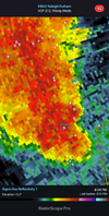
Severe tstorm warning based on the last few weeks, thunder and an OFB inbound
BHS1975
Member
I think so on the other side of the neighborhood under that purple pixel i could hear it on the roofsHail?

