Getting thunder now from a cell that has popped up a couple miles to my west.
-
Hello, please take a minute to check out our awesome content, contributed by the wonderful members of our community. We hope you'll add your own thoughts and opinions by making a free account!
You are using an out of date browser. It may not display this or other websites correctly.
You should upgrade or use an alternative browser.
You should upgrade or use an alternative browser.
Pattern July '22
- Thread starter Detective WX
- Start date
Shaggy
Member
Morning lows on the EURO:


Brent
Member
Can we just fast forward to September. Say what you want about winter but at least there was some variety lol

100*F at DFW as of 4pm. 10th day of the year.
Where the storms at?
Looks like it will be later, I think front is delayed as wellWhere the storms at?
NoSnowATL
Member
Can’t get a storm to save my life. It’s been a awful summer for storms in my hood.
GarnerNC
Member
Looks like it will be later, I think front is delayed as well
Keeping my fingers crossed, my wife wants us to talk the mile and half to fireworks tonight and there's not enough moisture wicking shirts available that would help
Downeastnc
Member
I just had more rain in the last 30 mins than I did in the entire month of June....
Shaggy
Member
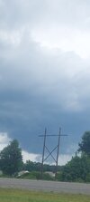
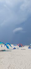
This beast of a storm is just north if me and isn't gonna be an issue for me. Some great views and some awesome lightning off in the distance far enough away to not run us off the beach
Attachments
Looks like it will be later, I think front is delayed as well
We'll see. They were supposed to be here at 2:00 and there's been nothing so far.
Bannerdude
Member
The NAM had me excited for some heavy rains to move though the area today. Oops.
Sounds like the forecast for storms today is a bust.
100*F at DFW as of 4pm. 10th day of the year.
Official high was an intra-hour 101*F.
Lol rain chances
Cad Wedge NC
Member
Got a small sprinkle with 2 rumbles of thunder. Does that count?Sounds like the forecast for storms today is a bust.
Looks like our next chance to not rain will be Wednesday through Saturday. Pattern looks good but we haven't been close to or over performed models on qpf/coverage in months so 0.00 through the work week seems like a good bet
BHS1975
Member
Looks a bit faster to me.Looks like it will be later, I think front is delayed as well

Totally blew it here today, my goodness so close but so farLol rain chances

Brutal. I'm not sure what rah was sold on today besides the 3k and fv3 but you kind of had to know we were in trouble when the pre frontal trough was to our south this morning. It's amazing how hard it is to get substantial rain though
?

BHS1975
Member
HRRR has been on point. It's showing back building later.
HRRR has been on point. It's showing back building later.

Guarantee the 50% later this week ends up 20% when we get there.Lol rain chances
You're optimistic. Get the front through Wednesday and we might be able to do 0%Guarantee the 50% later this week ends up 20% when we get there.
BHS1975
Member
We need a front to hang out near the VA border so the trough is over us.You're optimistic. Get the front through Wednesday and we might be able to do 0%
Forget later this week. They couldn't even get the forecast right for the current day.Guarantee the 50% later this week ends up 20% when we get there.
Lol


Last edited:
Did it ever get there? Somehow I got .17.
Downeastnc
Member
Can't complain about yesterday....

No.Did it ever get there? Somehow I got .17.
.png")
I see RAH is in hype mode about Wednesday I'll be sure to plan on a dry day
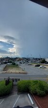
What's it like?Can't complain about yesterday....
View attachment 119673
Yeah, I have seen more 50+% chances 2-3 days out evaporate this year than ever.No.
View attachment 119672
I see RAH is in hype mode about Wednesday I'll be sure to plan on a dry day
Bannerdude
Member
0.01" sympathy sprinkle overnight
Have received 1.29" since May 28th
Have received 1.29" since May 28th
No kidding it's been brutal. Fortunately the means look amazing over the next 2 weeks with the heat ridge stuck in the west and broad troughing in the east. It'll be hard to unsee the near 4 inch mean from the 0z eps. We have a decent chance here to erase the D0 for our area and potentially the D1/2 areas as well. Given our track record since April I expect total failYeah, I have seen more 50+% chances 2-3 days out evaporate this year than ever.
Happy 4th! Baby derecho incoming
Shaggy
Member
I'll just plan a vacation in your area. Sure to rain it's ass off then. Just had lightning strike about 300 yards away.No kidding it's been brutal. Fortunately the means look amazing over the next 2 weeks with the heat ridge stuck in the west and broad troughing in the east. It'll be hard to unsee the near 4 inch mean from the 0z eps. We have a decent chance here to erase the D0 for our area and potentially the D1/2 areas as well. Given our track record since April I expect total fail

Last edited by a moderator:
Happy 4th from KDH