• Hello, please take a minute to check out our awesome content, contributed by the wonderful members of our community. We hope you'll add your own thoughts and opinions by making a free account!

Pattern January Thread - The Final Chapter

There's still hope ! This is what FFC had to say this afternoon in regards to Sunday evening and night:

Temps
during the latter portion of the evening into the early overnight
hours will be supportive of a light rain/snow mix across north
Georgia (north of metro ATL into the mountains) and all snow highest
elevations.
If I can at least see some flakes or get a dusting I will be satisfied if it is just a weak clipper.
 
You should contact him ASAP and ask him how buying a sled worked out for him. LOL!


Sent from my iPhone using Tapatalk

My sled is like my 401k. It ain't about the immediate returns. We are talking LONG term investment here!


Sent from my iPhone using Tapatalk
 
There's still hope ! This is what FFC had to say this afternoon in regards to Sunday evening and night:

Temps
during the latter portion of the evening into the early overnight
hours will be supportive of a light rain/snow mix across north
Georgia (north of metro ATL into the mountains) and all snow highest
elevations.

Kiss of death. Total fail. Kill the thread.


Sent from my iPhone using Tapatalk
 
Had a crazy temperature difference today ahead of the front. Went from 34 this morning to 69, a 35 degree rise, but the 69 again in January is just unbelievable. Something has to be coming later on next month.
 
Had a crazy temperature difference today ahead of the front. Went from 34 this morning to 69, a 35 degree rise, but the 69 again in January is just unbelievable. Something has to be coming later on next month.
It went from 32 to 67 here. Very reminiscent of a March day where there are wild swings in temps from morning to afternoon.
 
Wow, it's not even forecast to make it to freezing at the ATL airport in the next week. I wonder if it's really possible that ATL has already had their last freeze ?
 
Grasping at a straw (hopefully not the last straw), the 18z gfs is dropping the s/w a little further west and is a tad sharper than previous run. Here's hoping for a token flake!
 
Had a crazy temperature difference today ahead of the front. Went from 34 this morning to 69, a 35 degree rise, but the 69 again in January is just unbelievable. Something has to be coming later on next month.
Crazy swing in temps for sure. I would be surprised if we didn't see at least one threat next month. Hopefully that threat doesn't turn out to be severe weather since we will probably see plenty of that come March and April.
 
Looking little bit more interesting on the 18z GFS...but not by much.

Sent from my SM-J700T1 using Tapatalk
 
FFC is reaching. Maybe in the far north they'll see some flurries but that's it. As for Tennessee/far WNC/Kentucky/West Virginia, this actually looks somewhat interesting. If something similar happened it'd be a nice little event there.
 
FFC is reaching. Maybe in the far north they'll see some flurries but that's it. As for Tennessee/far WNC/Kentucky/West Virginia, this actually looks somewhat interesting. If something similar happened it'd be a nice little event there.
You think this could be a chase worthy event ? Meaning some areas maybe getting 4" or more ?
 
You think this could be a chase worthy event ? Meaning some areas maybe getting 4" or more ?

This wouldn't be my cup of tea but I'm thinking a widespread dusting-1 outside of the mountains in Tennessee, and then more in the mountains but some of their snow may be upslope from a different period. West Virginia would be the place to go to if anything similar worked out and yeah...I wouldn't mind traveling a little ways but that'd be too far even if I was still in North Georgia.
 
Yeah, we are all sick to some degree. However, I am with you concerning watching a potential system until it is obviously not going to materialize. That's just how most of our brains work.
Fortunately for us the storms don't look at the models to decide when to come and how to act, lol. Most of the storms I remember fondly just came up whether the models wanted them to or not. I think that moisture underneath over the weekend on the Gfs will product some sleet across the central and south and mostly because Goofy has been adamant in not allowing it to :) I love contrarian weather....I want the surprise. It's not sick, it's logical, lol.
 
Just looking over the Euro weekly. That stronger clipper coming down on the last day of this month into the 1st is wetter than 18z GFS. This is possible because a HP slips out to Bermuda. Something could bigger happen with that 2nd disturbance but it would be warmer. If it turns out to be something more, some will get plain rain, winter mix and some will get snow.

Sent from my SM-J700T1 using Tapatalk
 
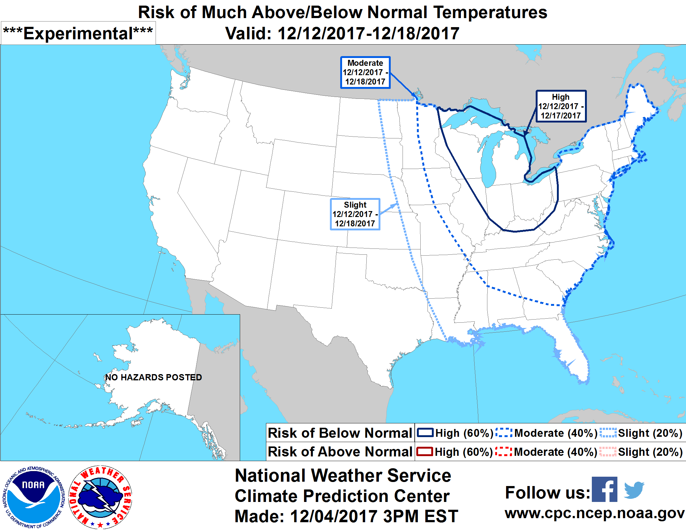
this only goes through Feb 8th so far...wonder if those cold temps will head SE after that?
probhazards_d8_14_contours.png
 
0z GFS is rolling out...standing by. It may be more interesting, specially with that second disturbance. So far, WV looks like they will get some good snows. Anyone here from WV?

Sent from my SM-J700T1 using Tapatalk
 
Looks like the trough is more vertical than a tilt. More interesting for sure than 18z GFS.

Sent from my SM-J700T1 using Tapatalk
 
0z GFS is rolling out...standing by. It may be more interesting, specially with that second disturbance. So far, WV looks like they will get some good snows. Anyone here from WV?

Sent from my SM-J700T1 using Tapatalk
Wrong side of the mountains here. I might move after I retire:) Like the idea of winning on NWflow events. Beautiful country out that way too! On topic, it is sad that it looks like we lost the sustained cold look from several days ago.
 
Watching that 2nd disturbance as well at 108-114.

Sent from my SM-J700T1 using Tapatalk
 
So this one has some precip in ENC...that's an interesting development. At the very least, this kind of set up is very frustrating and one or two tweaks could cause a completely different outcome than what we thought was going to happen. Not saying it will though, but it's possible.
 
I'm thinking that 2nd disturbance will have more moisture as it moves west to east. That second disturbance should develop more interesting looks on each run. I like the looks of this. HP over the Plains giving us a north wind.

Edit: That second disturbance could possibly come down further south.

Sent from my SM-J700T1 using Tapatalk
 
0z CMC is wetter and the low is further south but not by all that much with that second disturbance. That second disturbance will be worth keeping an eye on as well. If that low comes even further south, it will also push the colder air further south.

Sent from my SM-J700T1 using Tapatalk
 
For some, even if precipitation maps on these models don't show anything, I would think you'd see flurries as the energy consolidates and tries to spark something (and fails).

I'm willing to bet a big chunk of those in the SE who are close to freezing at the boundary layer will see little flurries around. I would not be surprised with the lower thicknesses involved, to see flurries down to areas like ATL, CAE, FLO, MYR, WLM, CLT, RAL.

Those are just some examples at I-20 and above in the GA/SC/NC region. The moisture that gets involved from the interaction will be squeezed out, if that makes sense. Not saying anything like a big event. Just don't be surprised close to I-20 and north in those areas if you notice some tiny flurries around, like dandruff.
Any chance North GA gets a light dusting ?
 
Any chance North GA gets a light dusting ?
I wouldn't go with that. That would be a really cool thing to see, forecast or not though.

Our guys at CAE mentioned the EURO (earlier today at 12z) was a bit more robust with precipitation. So I would think N. GA is in a good spot to seem a little more than flurries. A dusting? Might be stretching it with the data I have seen recently. Lets hope it over produces for you.
Seeing snow falling in the beginning and end of a month that was otherwise a torch would be pretty remarkable.
 
Back
Top