Definitely noise and the euro has been adamant on stupid cold temps as well.

Last edited:
about where we need it at this point though fully down the equator might make it even betterBoth AI models have the storm but suppress it to Cuba. That AIGFS though is playing with fire.
Textbook. If that upper air pattern verifies and doesn't turn to crapola, we will 100% get actual snow.No way anything misses us to our NW in this pattern…no chance….i triple dog dare it too
View attachment 187407
Always takes some luck, but I really like this period (next weekend). Pac Jet extending with Greenland ridge retrograding into Hudson Bay. Good combo to get some fantasy storms showing upBoth AI models have the storm but suppress it to Cuba. That AIGFS though is playing with fire.


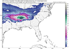
Always takes some luck, but I really like this period (next weekend). Pac Jet extending with Greenland ridge retrograding into Hudson Bay. Good combo to get some fantasy storms showing up
View attachment 187494
Weathernext Ensemble
View attachment 187498
Snow trend on GEFS
View attachment 187496
EPS Snow Trend
View attachment 187497
Yes if this sticks the next few days it may be the most pessimistic storm thread of all timeEncouraging signs from the ensemble runs. I'll wait until we're 48 hours out at the most this time. My faith is running low


This is just stupid. I've seen the GFS try to do stuff, but this takes the cake. This aint wind chills either.
View attachment 187535
Actually this wouldn't be crazy. Gonna be a heck of a lot or snow pack over the Midwest shortly and I doubt it's going anywhere..
Unfortunately I think our bust here on this threat is another beach blizzard with the barocyclinic boundary sitting off the gulf coast...
Without a doubt.I will play those odds again as crazy as it sounds.
Dude this got me laughing so hard ppl came into my office to share the joke with them!!!dream season in play View attachment 187350
And there’s support. I’ll never sleep again View attachment 187351View attachment 187352
Actually this wouldn't be crazy. Gonna be a heck of a lot or snow pack over the Midwest shortly and I doubt it's going anywhere..
Unfortunately I think our bust here on this threat is another beach blizzard with the barocyclinic boundary sitting off the gulf coast...


Looks awful familiar
Bam gonna be fighting for this one too. There appears to be a storm


I might not even be interested the day of. Power might still be out.I won't even be interested unless it's showing it the day beforehand.


View attachment 187573
Cant wait for the northern branch to trend awfully and this is in Cleveland Ohio

If blocking isn't strong enough or doesn't hang around, well, we know the drill.That’s split flow heaven along the west coast with cold TPV pressing down. Leave the southern wave alone and let it cook. It’s the “good” El Niño pattern
View attachment 187581
For real...i'm not confident at all power would be even restored by then where i am.I might not even be interested the day of. Power might still be out.
The good news is this is a real low pressure that will draw cold air into it, unlike this weekends slop. Its almost the same as last nights EURO. Sure, it can end up well NW but at least its a solid low.If blocking isn't strong enough or doesn't hang around, well, we know the drill.