• Hello, please take a minute to check out our awesome content, contributed by the wonderful members of our community. We hope you'll add your own thoughts and opinions by making a free account!

Wintry January 23rd-27th 2026

View attachment 188774
Absolutely awful. And we are still a couple hours away from the big band to come through here.
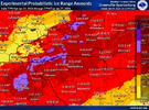
That's definitely bad but it's a real improvement of what was being shown just 24 hrs prior.
I love the trends of less precip along the 85 corridor.
I have grown accustom to having power, heat, & hot water!
I hope that trend continues!
 
SPC Mesoscale Discussion for 0.05-0.1” per hour freezing rain rates over the western Piedmont of NC.

View attachment 188794

View attachment 188793

https://www.spc.noaa.gov/products/md/md0047.html

825b634bc3458c4739cc83a3c31663b7.jpg

28b96a5c9a3e77a1eaafc39017e09cd8.jpg

8359a0cd4d0cbf80391bcaa48b18c27c.jpg

Just wanted to say….. this ain’t sleet. Not a pinger has been heard in about 20 min. I just be on some transition line but this is 100% snow for last 20 min. Sleet doesn’t float like this pixie dust is, and you can brush it and it’s dry and fluffy on top not like sleet…… Dusting Mooresville NC 11PM EST …..Hwy152/Linwood Rd


Sent from my iPhone using Tapatalk
 
For the upstate; to this point there has been almost no precip to speak of, other than random drops or pellets, and this might be a great development for us. I am sure we will get a good bit still overnight and tomorrow but not getting this early round of infil zr has got to help on our overall totals. So far, precip has dried out past Athens or so. This is the most I have seen on radar all night and this is very light or not reaching the ground. The under on zr is our best bet to avoid a total mess. Really, almost the whole state of SC is dry. If this were snow I'd be so upset I'd be beside myself but this time it's probably a good thing.
 

Attachments

  • Screenshot_20260124_230302_Chrome.jpg
    Screenshot_20260124_230302_Chrome.jpg
    937.4 KB · Views: 45
825b634bc3458c4739cc83a3c31663b7.jpg

28b96a5c9a3e77a1eaafc39017e09cd8.jpg

8359a0cd4d0cbf80391bcaa48b18c27c.jpg

Just wanted to say….. this ain’t sleet. Not a pinger has been heard in about 20 min. I just be on some transition line but this is 100% snow for last 20 min. Sleet doesn’t float like this pixie dust is, and you can brush it and it’s dry and fluffy on top not like sleet…… Dusting Mooresville NC 11PM EST …..Hwy152/Linwood Rd


Sent from my iPhone using Tapatalk
Wow, I'm jealous! Agreed that looks like high-ratio snow, at least from the photos. That's the kind of small snowflakes that will actually fall in between the grass blades!
 
For the upstate; to this point there has been almost no precip to speak of, other than random drops or pellets, and this might be a great development for us. I am sure we will get a good bit still overnight and tomorrow but not getting this early round of infil zr has got to help on our overall totals. So far, precip has dried out past Athens or so. This is the most I have seen on radar all night and this is very light or not reaching the ground. The under on zr is our best bet to avoid a total mess. Really, almost the whole state of SC is dry. If this were snow I'd be do upset I'd be beside myself but this time it's probably a good thing.
Radar doesn't tell the story. My car and grass is already glazed over without a radar return to speak of. There's a legit light rain right now, also.
 
Chances of zr filling in more towards Augusta throughout the evening? We're right on the southern edge of expected ZR between .10 and .25. Everything seems to be missing us to the north, but there does seem to be some rain from the coast throwing moisture back our way. Thoughts?
 
825b634bc3458c4739cc83a3c31663b7.jpg

28b96a5c9a3e77a1eaafc39017e09cd8.jpg

8359a0cd4d0cbf80391bcaa48b18c27c.jpg

Just wanted to say….. this ain’t sleet. Not a pinger has been heard in about 20 min. I just be on some transition line but this is 100% snow for last 20 min. Sleet doesn’t float like this pixie dust is, and you can brush it and it’s dry and fluffy on top not like sleet…… Dusting Mooresville NC 11PM EST …..Hwy152/Linwood Rd


Sent from my iPhone using Tapatalk

This is probably why you’re seeing snow

 
Radar doesn't tell the story. My car and grass is already glazed over without a radar return to speak of. There's a legit light rain right now, also.
Well of course I can't speak for everywhere, just what has generally happened so far and what the radar shows. I walked out here about 30 minutes ago and it's not even wet at my place; I haven't gotten anything at all yet. Most people in the upstate with similar reports. Regardless, we haven't had the development this evening and that's probably a good thing for most.
 
Well if we're gonna really add up it's now or never View attachment 188764
I love you brother. But, isn’t there an “Outside the SE Thread”? I love your posts and myself don’t mind at all. However, A life safety event is occurring across the SE. Look … I’m of the opinion “If you don’t like it just scroll past” OH.. I also understand the upstream updates. Appreciate the updates Brent. 🙏
 
Well of course I can't speak for everywhere, just what has generally happened so far and what the radar shows. I walked out here about 30 minutes ago and it's not even wet at my place; I haven't gotten anything at all yet. Most people in the upstate with similar reports. Regardless, we haven't had the development this evening and that's probably a good thing for most.
Started having drizzle about 10:45 here,
It's a steady drizzle now very light and being pushed sideways by the steady NE winds!
Temp in the mid 20's
So hopefully we miss the catastrophe that some models were showing.
Still bad just not a catastrophic.
 
Back
Top