BufordWX
Member
It don’t take long to add up when every flake sticks from the start! Good luck and enjoy! I’d be up all night staring out the window! Once in a lifetime event in your backyardGood grief people are gonna be shocked how much snow we get I think View attachment 188339View attachment 188340
Impressive. Over half the states under a winter storm warning at the same time
View attachment 188353
It don’t take long to add up when every flake sticks from the start! Good luck and enjoy! I’d be up all night staring out the window! Once in a lifetime event in your backyard
-7 here currently
PER MEMPHIS NWS CHATROOM ALREADY GOT SLEET MIXED WITH SNOW PER SEVERAL REPORTSLooks like the returns in N Mississippi are already reaching the ground a bit. Couple of mPING reports of ZR/IP. View attachment 188364
RAH did as well. I am curious if they are seeing more sleet mix in or what because I haven't seen any model shifts that would seem to necessitate it otherwise. I understand these maps are at least partially automated based on the NBM, though?
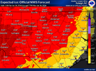
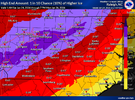
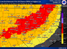
It’s the same. They’ve just increased the range of outcomes. Instead of 0.5-0.75” like it had it’s 0.4-0.85” in the upstate for example
This does seem to have borne fruit. Much more precip into central NC by hr 33.Seeing more storms / heavier precip popping up in the Gulf and southern Louisiana at hr 18 of the 06z NAM compared to the 00z run (where said storms were in central MS). Based on my understanding, this should lead to increased moisture transport into NC / SC / GA / etc. down the line, although I'll probably be wrong.
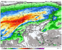 00z:
00z: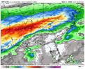


Glad it isn’t snow. Bc this is so Columbia. Glad since it’s ice.The only thing really saving the Midlands is lack of moisture. If the axis of moisture shifted South, Central SC would be in a lot of trouble. The atmosphere is locked in for a significant Winter storm.. Just going to get dryslotted.
Let’s hope that is the case. Would be helpful to a lot of us.From what im reading “drizzle” rain drops will 100% be sleet pellets in the upstate tonight. Our freezing layer goes up to about 890mb, with temps as low as -8 to -10c in the heart of it.
Since our precip rates will generally be low and drizzly, I’m expecting at least half of our qpf will go towards sleet.
How reliable is this? I would love that outcome.RRFS with that precip hole from eastern Carolina’s back to CLT-RDU. Posting it so we can see how it does.
This doesn’t include that final band.
View attachment 188386
That is what I'm praying for. A couple of inches (or more) of sleet and just a little freezing rain to make the trees shine. This look would be a big win.
So for the upstate that would cut down the ZR to around .5 or so in your opinion?From what im reading “drizzle” rain drops will 100% be sleet pellets in the upstate tonight. Our freezing layer goes up to about 890mb, with temps as low as -8 to -10c in the heart of it.
Since our precip rates will generally be low and drizzly, I’m expecting at least half of our qpf will go towards sleet.
That actually looks like a very realistic sleet map to me.
Yes I think there will be less ice in the heart of that 925mb cold tongue across the upstateSo for the upstate that would cut down the ZR to around .5 or so in your opinion?
